
Chapter 8 - Igneous Rocks &Volcanic Activity |
Origin of Igneous RocksThe Earth stores vast quantities of energy in the form of kinetic heat. Portions of the Earth's interior are molten, such as the outer liquid core. However, rocky materials in the overlying mantle are thought to be under too much pressure to melt. However, in many places, heat flow near the Earth's surface is high enough and confining pressure is low enough for rocks to melt. This molten material may find zones of weakness, such as along fault zones, to inject, melt, or under great pressure, find means to migrate to the surface.The heat released by volcanoes and volcanic activity ultimately comes from heat convection from the Earth's core and mantle. Traces of that energy are released all over the surface of the planet, but that release of energy is not evenly distributed on the surface. The amount of energy released as geothermal energy is only a very tiny fraction compared to the solar energy the Earth receives from the Sun. The Geothermal GradientIn most regions, the average temperature increases an average of 20 to 30 degrees C per kilometer with increasing depth in the upper crust. This temperature gradient (called the geothermal gradient) varies considerably with depth and location, depending on geologic settings. Regions actively experiencing plutonism and volcanism are locations where hot material may be located closer to the surface.What causes rocks to melt?Rocks will melt (generating magma) if heat flow increases in an area to the point that minerals reach their melting points. Other factors that cause melting include the introduction of hot volatile fluids (water and gases) into rocks under pressure, or if there is a decrease in pressure confining hot rocks (such as the release of pressure caused by a great earthquake). Melting ranges from only partial melting of select low-temperature minerals to complete melting under higher temperature conditions. As heat flow increases, more materials will potentially melt. |
 Fig. 8-2. Heat convection from the mantle is the source of heat driving volcanic activity. This heat is remnant from its period of Earth's formation and the decay of radioactive elements. |
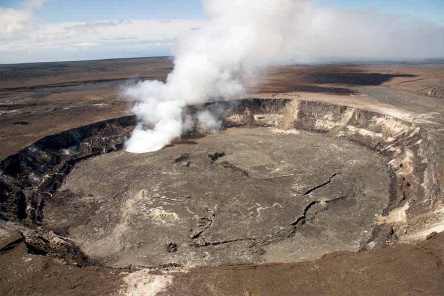
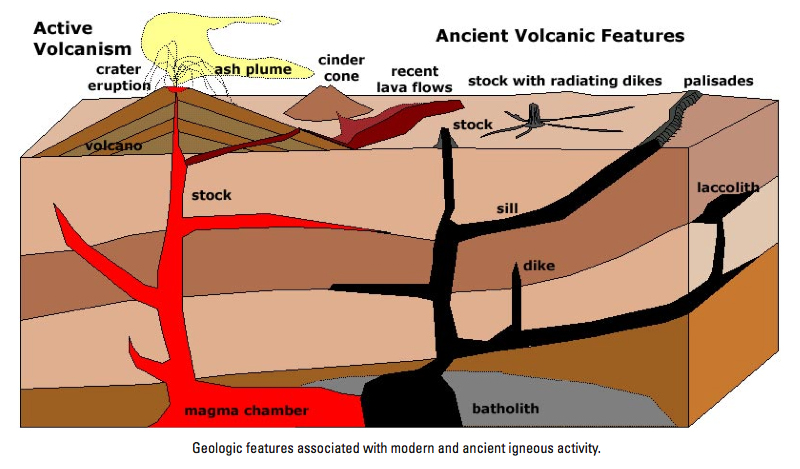
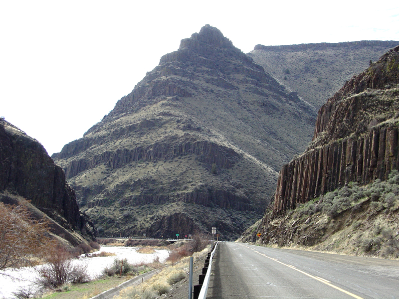
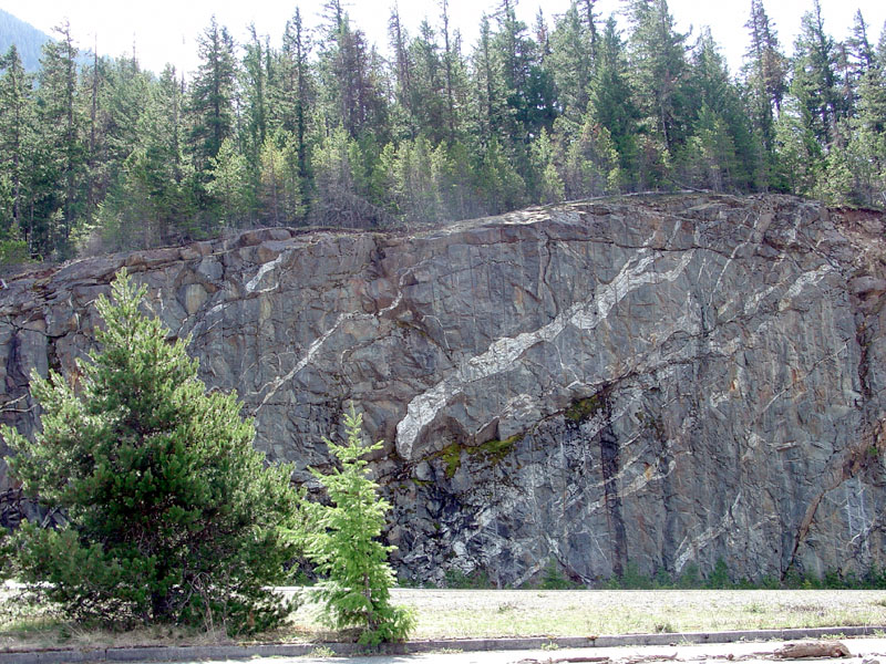
Igneous Rocks Are Rock Formed From Molten MaterialRocks formed from magma cooling and crystallizing underground are called intrusive igneous rocks. Intrusive igneous rocks form in naturally insulated settings (rock is a poor conductor of heat) so that minerals crystallize slowly, forming large, visible crystals.Rocks formed from cooling lava on or very near the surface are called extrusive igneous rocks. When lava cools rapidly it crystallizes quickly, preventing visible crystals from forming. Extrusive rocks include lava flows and pyroclastic material such as volcanic ash, cinders, etc. Plutonism refers magma moving, cooling, and crystallizing underground. A pluton is a body of igneous rock formed underground. Plutonic rock is a rock formed at considerable depth by crystallization of magma and/or by chemical alteration. It is usually medium- to coarse-grained with a granitic (phaneritic) texture. Volcanism is any of various processes and phenomena associated with the surface discharge of molten rock or hot water, steam, or gases. Volcanic rock is any rock formed by volcanism. A volcanic eruption occurs when molten material under pressure is expelled on the surface. Some may be discharged into the atmosphere or oceans producing a variety of rock fragments including large blocks, volcanic bombs (blobs that may have a hard crust and a partially molten interior), cinders, and ash. Molten material may flow on the surface under the influence of gravity. A volcano is a pile of volcanic rock that forms around a vent. Volcanic activity can also produce hot springs, geysers (erupting hot springs) and fumaroles (gas vents). |
 Fig. 8-3. Parts of a volcano illustrating select features Fig. 8-3. Parts of a volcano illustrating select features |
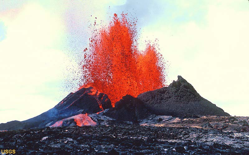
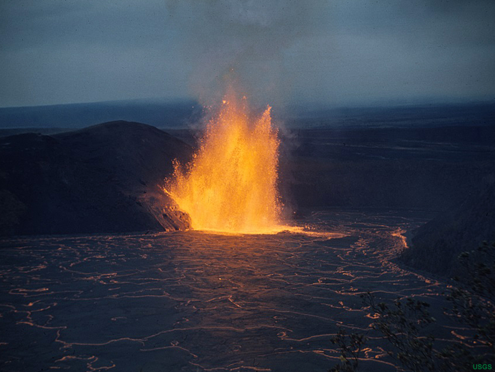
Why do volcanoes erupt?Magma migrates to the surface under extreme pressure created by the weight of the rock above it and also from the pressure of gases dissolved within it (much like a warm can of a carbonated soda or beer). Degassing is the process of the separation of volatile gases (CO2, SO2, H2S, etc.) and steam (H2O) from molten material (magma or lava).Magma of granitic composition can have as much at 5 percent water dissolved in it. The release and expansion of gases is the driving force in volcanic explosions and eruptions (Figures 8-4 and 8-5). Where do volcanic gases come from? Some of it is new (from the mantle such as at divergent zone) and some of it is recycled from older crust sinking into a subduction zone. Studies of carbon isotopes (C13/C12) show that carbon emitted from Cascades volcanoes has essentially the same isotopic signature as carbon in sediments deposited in the ocean basin trenches offshore of Oregon and Washington. Figure 8-6 shows the composition of volcanic gases from different geologic settings. Water and carbon dioxide are the dominant gazes released by volcanoes. |
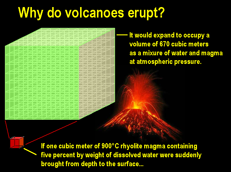 Fig. 8-4. Why do volcanoes erupt? Because magma contains large amount of dissolved gases! When magma containing dissolved water and gases is released in a volcanic eruption it expands hundreds of times in volume creating ash-filled clouds. |
 Fig. 8-5. Gases from volcanic eruptions 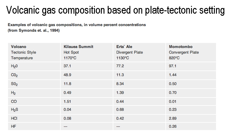 Fig. 8-6. Volcanic gases from different plate-tectonic settings Fig. 8-6. Volcanic gases from different plate-tectonic settings |
How hot is magma/lava?The temperature of magma/lava plays perhaps the most important factor influencing igneous activity (both underground and on the surface).Temperature influences: • how minerals either melt or crystallize, • how much volatile content magma/lava can absorb, hold, and release. • how it influences the character of the volcanic eruptions. • the composition of rocks that can form when the material cools. • the texture of the rock that forms with the molten material solidifies • the kinds of volcanic landscape features eruptions can produce. The table below illustrates the temperature of lava sampled from a variety of volcanoes around the world. The table compares temperature of selected lava samples with their rock composition, geologic setting, and types of volcanic eruptions they produce. Note that the hottest lava is found on Hawaii's Kilauea volcano. Note that the hot lava volcanoes tend to produce the more gentle, yet extensive eruptions. In contrast, the cooler the lava the more explosive the eruptions tend to be. This is partly because the cooler the magma/lava, the less fluid it is, and it tends to have higher concentrations of dissolved gases that can be released explosively during an eruption (see Figure 8-4). |
||||
| Lava/Rock composition (place) | Geologic setting | Temperature (C) sample (estimate range) |
Temperature (F) sample (estimate range) |
Type of volcanic eruptions |
| Basalt (Kilauea, Hawaii): |
hotspot - shield volcano | 1,170 (1,000-1,250) |
2,138 (1,832 to 2,282) | hot, fluid eruptions with extensive lava flows, rare explosive eruptions |
| Basalt (Erta Ale, Ethiopia) |
divergent zone - rift zone - shield volcano | 1,130 | 2,066 | hot, fluid eruptions with extensive lava flows, rare explosive eruptions |
| Andesite (Mount Pelee, Martinique) |
convergent zone - arc - composite cone | 1,075 | 1,967 | explosive eruptions and pyroclastic flows |
| Andesite (Lascar volcano, Chile) |
convergent zone - arc - composite cone | 1,069 (950-1,200) | 1,956 (1,742 to 2,192) | both explosive eruptions and lava flows |
| Dacite (Mototombo, Nicaragua) |
convergent zone- arc - composite cone | (800 to 1,100) | (1,472 to 2,012) | both explosive eruptions and lava flows, lava domes, pyroclastic flows |
| Dacite (Mount St. Helens, Washington) |
convergent zone- arc - composite cone | (750 to 850) | (1,382 to 1,562) | both explosive eruptions and lava flows, lava domes, pyroclastic flows |
| Rhyolite (Yellowstone National Park) | continental hotspot | (700-900) | (1,292 to 1,652) | very large, catastrophic explosive eruptions, regional ash fall coverage |
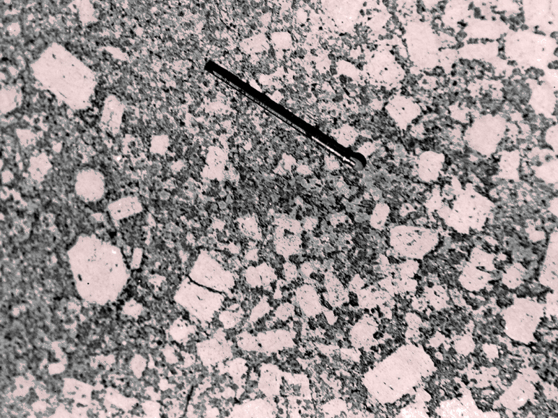
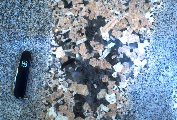
General Characteristics of Intrusive and Extrusive Igneous RocksThe factors the help produce the texture and appearance of igneous rocks include: 1) the amount of dissolved gases in magma, 2) the rate at which magma cools, and 3) the amount of silica (SiO2) present.Intrusive igneous rocks form in naturally insulated settings (rock is a poor conductor of heat) so that minerals crystallize slowly, forming large, visible crystals. Extrusive igneous rocks that form from rapidly cooling magma (or lava) near or on the surface, crystallize quickly, preventing visible crystals from forming. Note: Both rocks shown below have the same mineral (and chemical) composition, but different texture due to the rate of cooling of the molten material. |
|||
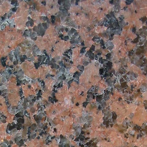 |
Figure 8-6. Phaneritic texture is a term usually used to refer to igneous rock with a larger crystal grain size and texture. It means that the size of matrix grains in the rock are large enough to be distinguished with the unaided eye as opposed to aphanitic (which is too small to see with the naked eye). Rocks with phaneritic texture are usually intrusive igneous rocks. Magma underground cools and crystallizes very slowly allowing large crystals to form. |  |
Fig. 8-7. Aphanitic texture applies to dense, homogeneous rock with constituents that are so fine grained that they cannot be seen by the naked eye. Rocks with aphanitic texture are usually extrusive igneous rocks. Magma or lava at or near the surface tends to cool very quickly, preventing large crystals from forming, so the rock typically has a very fine-grained texture. |
| Intrusive igneous rock. This example is granite. | Extrusive igneous rock. This example is rhyolite. | ||
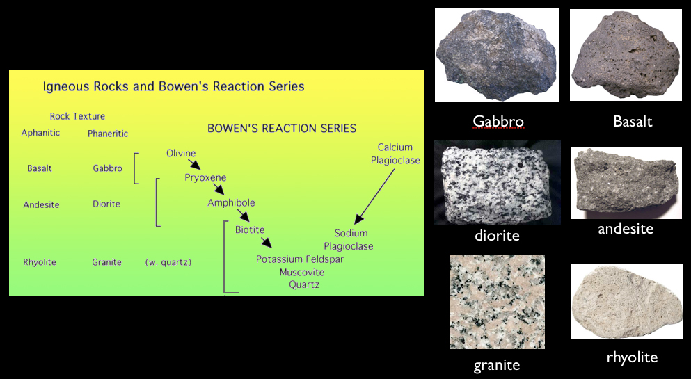
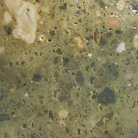
General Classification of Igneous RocksFigure 8-8 illustrates a general classification of igneous rocks. Igneous rocks are named based on combinations of their:1) mineral composition, 2) crystalline sizes, 3) general color, and 4) textural characteristics. 1) The mineral composition part is based on percentages of common rock-forming minerals of igneous origin and is the most accurate means of identifying an igneous rock. However, this method is difficult for fine-grained rocks without a microscope (Figure 8-8). 2) Crystal size is subdivided into 2 classes: visible crystalline grains (phaneritic) or grains too small to see with the naked eye (aphanitic)(discussed above with Figures 8-6 and 8-7). Igneous rocks with larger crystals are easiest to identify by mineral composition. 3) Color is an easy and perhaps most important way to generally classify igneous rocks, especially if mineral composition and crystals are difficult to see (as with most extrusive igneous rocks). The terms felsic, intermediate, and mafic are general terms used to describe and classify fine-grained igneous rocks (Figure 8-9; also see discussion below). 4) Textural characteristics are used to characterize some kinds of igneous rocks, and mostly applies to igneous rocks that form under special conditions. A textural name often relates to how a rock forms. For example, pumice is a volcanic rock that has so many gas bubbles in it that it can float! Obsidian, a rock that is sometimes used in jewelry, has a glass-like texture with a conchoidal fracture. |
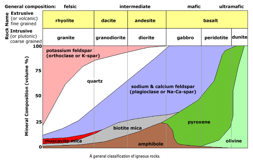 Fig. 8-8. Classification of igneous rocks based on mineral composition. (This method is useful only if larger crystal sizes allows mineral identification.) |
 Figure 8-9. Color of volcanic rocks. Light colored volcanic rocks are described as felsic; dark colored are mafic, and color shades in the middle are considered intermediate. |
How do different types of igneous rocks form from one original supply of magma?Igneous rocks form as molten material cools and crystallizes into rock. As the molten material cools, chemical compounds in the melt crystallize into minerals at different temperatures, with high-temperature minerals crystallizing first. These high-temperature minerals are denser than the molten material and tend to settle out in the bottom of a magma chamber (pluton). As the melt continues to cool, the composition of the melt changes as more crystals form and settle out. Finally the melt completely cools with the composition of the rock enriched in low-temperature minerals. This process is called magmatic differentiation.A simple comparison is what happens when seawater freezes. The ice that forms directly from seawater is nearly pure water in composition. As sea ice forms, the remaining seawater becomes enriched in dissolved salts, lowering the freezing temperature of the remaining seawater (concentrated as brine). As seawater freezes and crystalline ice forms, and liquid brine (concentrated salt water) and air are trapped in tiny pore spaces within a matrix of pure ice crystals. With further cooling, solid salt crystals subsequently precipitate in pockets of brine within the ice. The net volume of the ice, volume of brine, and chemical composition of the solid salts are temperature-dependent. |
|
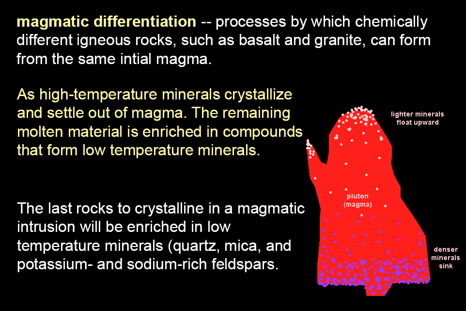 |
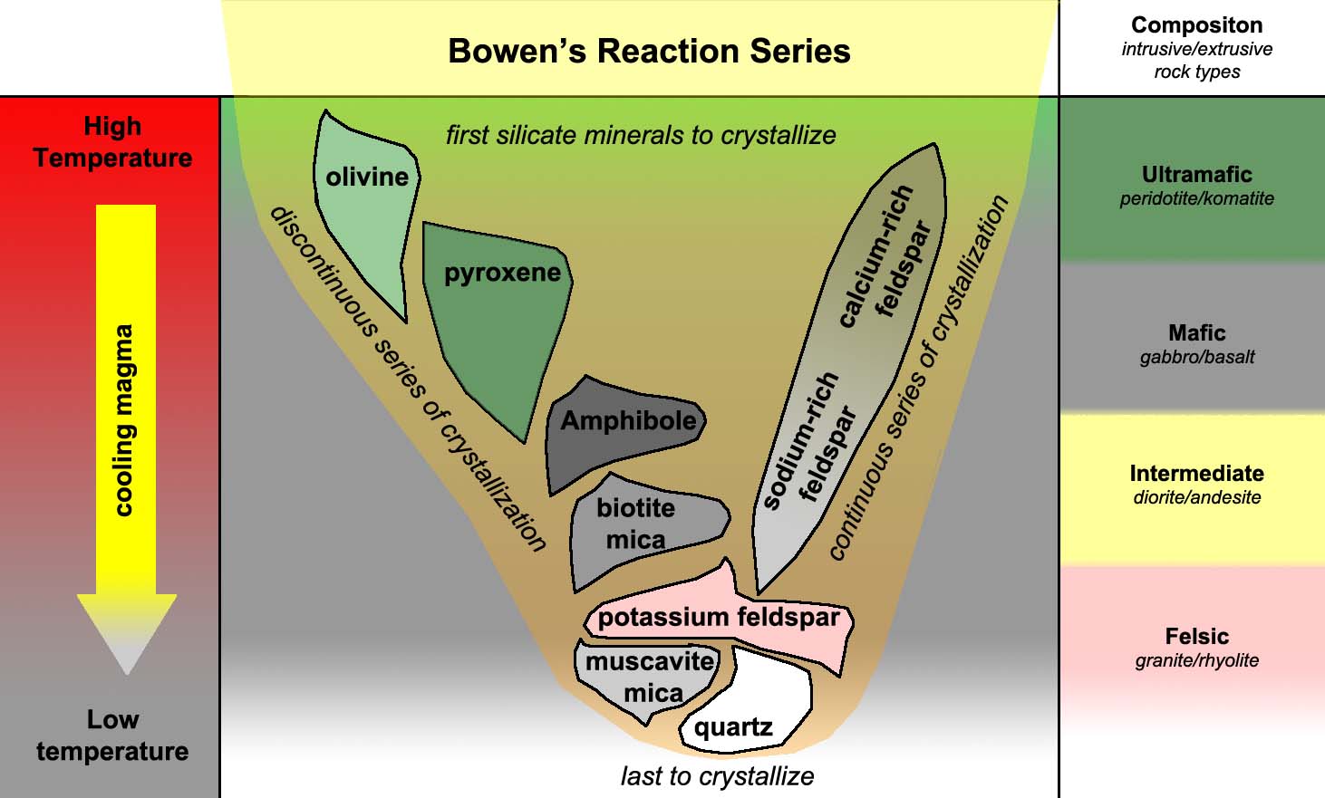
Magmatic differentiation involves processes by which chemically different igneous rocks, such as basalt and granite, can form from the same initial magma (Figure 8-10). High-temperature minerals can crystallize and settle out, causing the remaining molten material to be concentrated with component that may later form rock enriched in low temperature minerals (such as granite). The last rocks to crystallize in a magmatic intrusion will be enriched in low temperature minerals (quartz, mica, and potassium- and sodium- feldspars). Gases and fluids including water, carbon dioxide, nitrogen and other compounds are also dissolved in magma and will be concentrated in the remaining lava before being expelled as the last traces of magma cools into rock. |
| Fig. 8-10. Different rocks from from one magma by magmatic differentiation. |
|
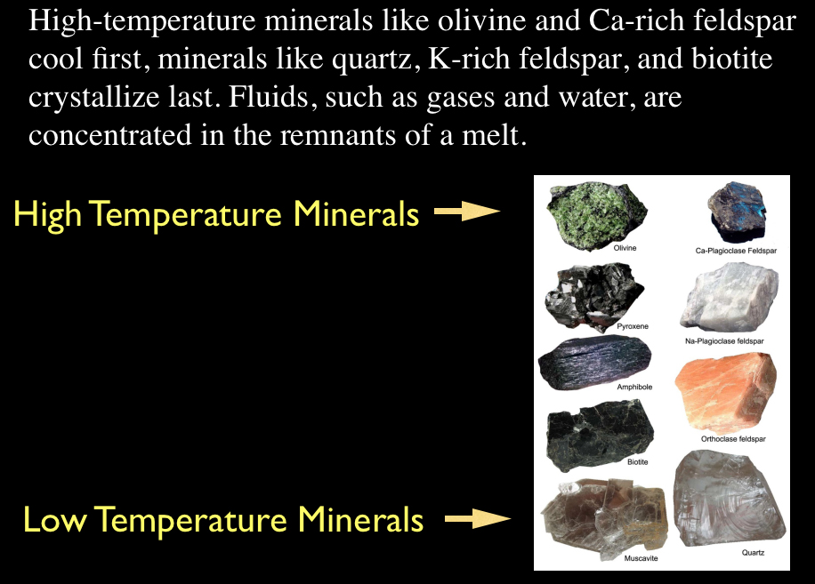
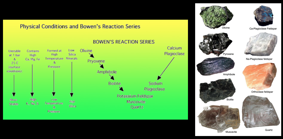
High temperature vs. Low Temperature Igneous Minerals (and the Rocks They Form)Felsic minerals melt at lower temperatures than mafic minerals.. This was demonstrated by the work of a 19th century petrologist, Norman Bowen, who showed that as a silicate-rich melt cools, minerals that form at higher temperatures will crystallize first. As these minerals crystallize, the chemistry of the remaining melt will change as it cools, allowing different minerals to form as the melt proceeds cooling. High-temperature minerals like olivine and Ca-rich feldspar cool first, minerals like quartz, K-rich feldspar, and biotite crystallize last (Figure 8-11). In addition, fluids, such as gases and water, are concentrated in the remnants of a melt. This pattern of mineral (and rock) formation is called the Bowen's Reaction Series (Figures 8-12 to 8-14). For example, in Bowen's Reaction Series, the first mineral that would crystallize from a high-temperature melt would be olivine. Conversely, quartz would be the last mineral to crystallize, and therefore granite is the last rock type to form as a melt cools and crystallizes if all the silica (SiO2) in a melt is not consumed as other high-temperature minerals form first. |
||||
|
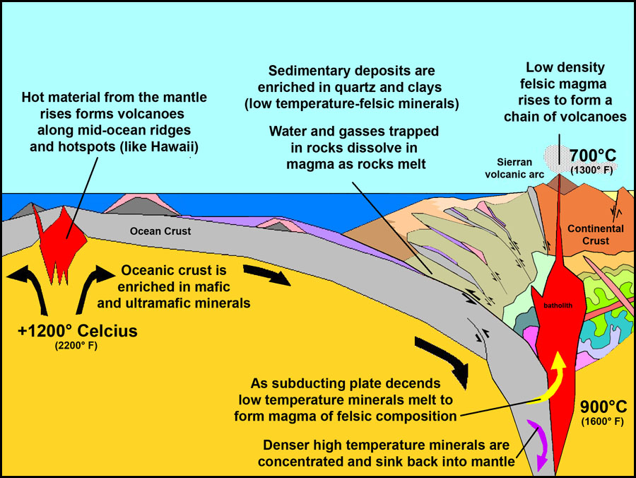
What is the significance of the composition of igneous rocks?Felsic is a term used to describe molten material (magma), minerals, and rocks which are enriched in the elements such as silicon, oxygen, aluminum, sodium, and potassium. The term combines part of the words "FELdspar" and "SILica". Most felsic minerals are light in color and have a density less than 3 grams per cubic centimeter (g/cm3) . Felsic minerals produce felsic rocks. Common felsic minerals include quartz, muscovite, and feldspars. Granite and rhyolite are common felsic rocks.Mafic is an adjective describing molten material (magma), minerals, or rocks that are enriched in magnesium and iron;. The term combines part of the words "magnesium" and "ferric" (ferric iron are compounds with the Fe+3 ion). Most mafic minerals are dark in color and the relative density is greater than 3 grams per cubic centimeter (g/cm3). Common rock-forming mafic minerals include olivine, pyroxene, amphibole, and biotite. Common mafic rocks include basalt and gabbro. Mafic rocks (rich in iron and magnesium) are generally denser and darker-colored than felsic rocks (rich in silica and aluminum). The term ultramafic is applied to rock composed chiefly of mafic minerals (rich in iron and magnesium, and less than about 45 percent silica, such minerals as olivine, augite, or hypersthene. Peridotite, pyroxenite and serpentinite are rocks with ultramafic rocks. The mantle is ultramafic in composition and has a density of about 3.5 grams or cubic centimeter (g/cm3). What is perhaps most important about mafic vs. felsic rocks is where they occur in different plate-tectonic settings: • Oceanic crust is dominated by mafic and ultramafic intrusive igneous rocks. • Continental rocks are dominated by granitic (felsic) intrusive igneous rocks. The difference in density has an impact on isostasy of crust floating on the semi-fluid upper mantle (asthenosphere), with continental crust (about 2.7grams/cm3) rising or floating above oceanic crust (about 3.5 grams/cm3). |
||||
|

How do different kinds of igneous rocks form, and where do they occur?Igneous rocks are subdivided into three different categories based on mineral composition: felsic, intermediate, mafic, and ultramafic. These three categories are then further subdivided into dominant rock types based one crystal size and their origin. |
|||||||||||||||||||||||||||||
|
|||||||||||||||||||||||||||||


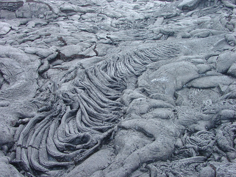
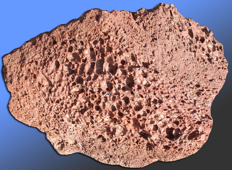
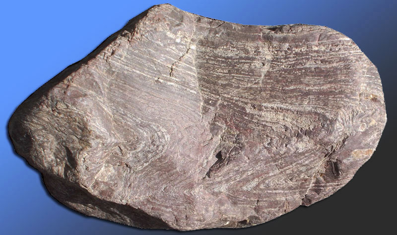
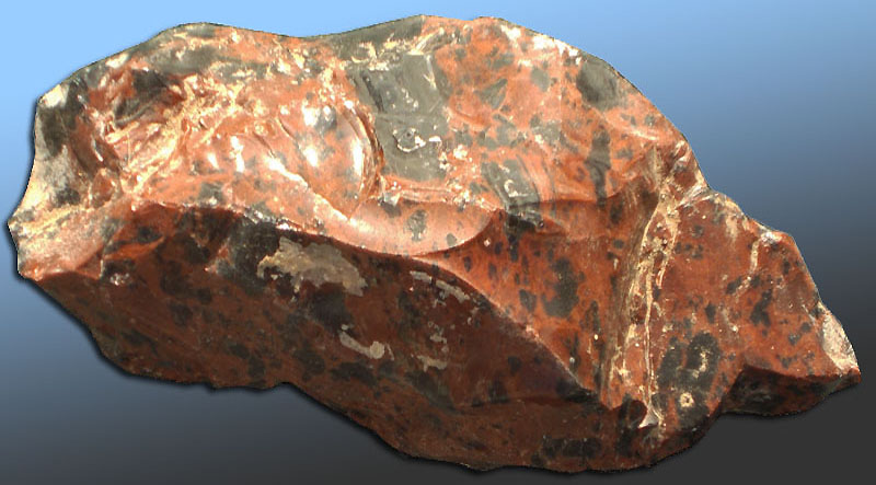
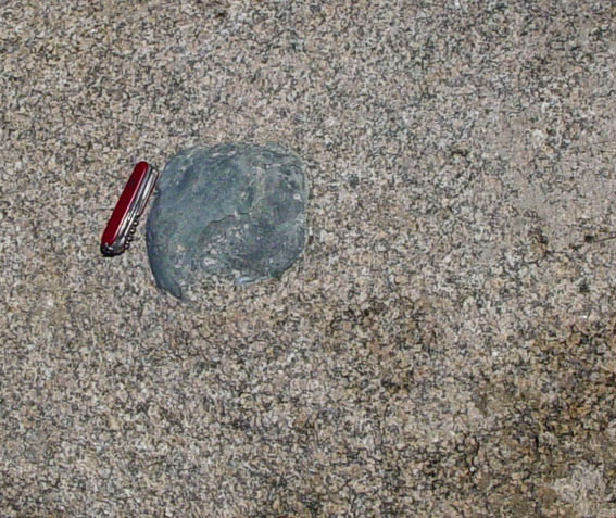
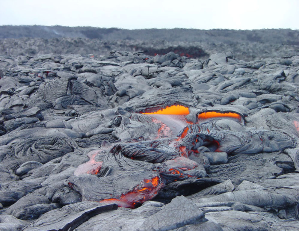
Volcanic rocks with unusual textures (and special names)Materials ejected from volcanic eruptions have some unique characteristics. Some are of interest to the gem community, not that they are gems or considered precious, but they can be cut or shaped into interesting variety of uses for jewelry and art. Visitors to Hawaii are introduced to the terms pahoehoe (pronounced "pā-hoi'hoi') and a'a (ä’ä) (Figures 8-27 and 8-28). Pahoehoe has a ropey fluid texture formed when hot basaltic lava cools quickly. A'a is lava rock with a rough, blocky surface when a lava flow continues to move slowly as it cools, and congealed rock breaks into rough pieces. People who walk on it barefoot frequently yell "Ah! Ah!" (Old Hawaiian joke).Vesicular lava rock is any igneous rock that has gas bubbles trapped in a fine-grained volcanic rock. Scoria is volcanic rock with a light, frothy consistency due to the high volume of gas bubbles trapped in the rock as it cools as lava is ejected from a volcano (Figure 8-29). If the rock is so frothy from trapped gas inside that it will float it s called pumice. Huge mats of pumice have been observed floating on the ocean after massive volcanic eruptions. Tuff is a volcanic rock that contains an abundance of visible fragments of volcanic rock that have been crushed or welded together by the heat released during an explosive volcanic eruption (Figure 8-30). Flow-banded lava rock is a volcanic rock that has a layered appearance due to flowing or stretching (like taffy candy) that formed as the lava was still flowing as it cooled (Figure 8-31). Obsidian is a dark, glass-like volcanic rock formed by the rapid solidification of lava without crystallization (natural glass)(Figure 8-32). Obsidian breaks with a conchoidal fracture like glass. Bubbles in volcanic rocks can fill with minerals, including gem minerals. Snowflake obsidian is very attractive when tumbled or polished. The snowflakes in the obsidian are crystals (phenocrysts) of feldspar. |
 |
 |
| Fig. 8-27. Pahoehoe lava has a ropey texture (Hawaii). | Figure 8-28. A'a lava has a rough, blocky texture (Hawaii) | |
 |
 |
|
| Fig. 8-29. Scoria or pumice | Fig. 8-30. Volcanic tuff | |
 |
 |
|
| Fig. 8-31. Flow-banded lava rock display lines where the partly molten lava stretched like pulling taffy. | Fig. 8-32. Obsidian (natural glass) is usually black but can occur in a variety of colors (from Glass Mountain, CA) |
Special Types of Igneous Rock Features and Rock Textures |
|
 |
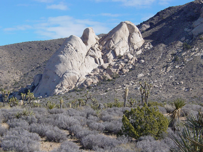
Xenolith—A rock fragment foreign to the igneous mass in which it occurs. Xenoliths are commonly composed of rock derived from the sides or roof of a magma chamber. The rocks sink into the magma chamber but escape melting as the magma cools to stone. Xenoliths stand out in appearance from the surrounding magma that cooled into stone around them. One of the basic geologic principles, the Law of Inclusions, dictates that the inclusion (xenolith) is older than the intrusion itself. |
| Fig. 8-33. Dark xenolith in granite in Joshua Tree National Park. Xenoliths tend to survive sinking into a pluton (magma chamber) if it is composed mostly of high-temperature mafic minerals. | |
 |
Porphyry—a hard igneous rock containing visible crystals (phenocrysts), usually of feldspar, in a fine-grained (microcrystalline) mineral matrix—typically a dark gray, reddish, or purplish ground mass. Phenocryst—a large or conspicuous crystal in a porphyritic volcanic or igneous rock, distinct from a more fine-grained ground mass (mineral matrix). Phenocrysts (crystals) form in magma at depth before it reaches the surface where the magma (or lava) cools quickly for form the fine-grained matrix. |
| Fig. 8-34. Feldspar phenocrysts in andesite porphyry Pink feldspar (K-spar) phenocrysts in andesite porphyry. | |
 |
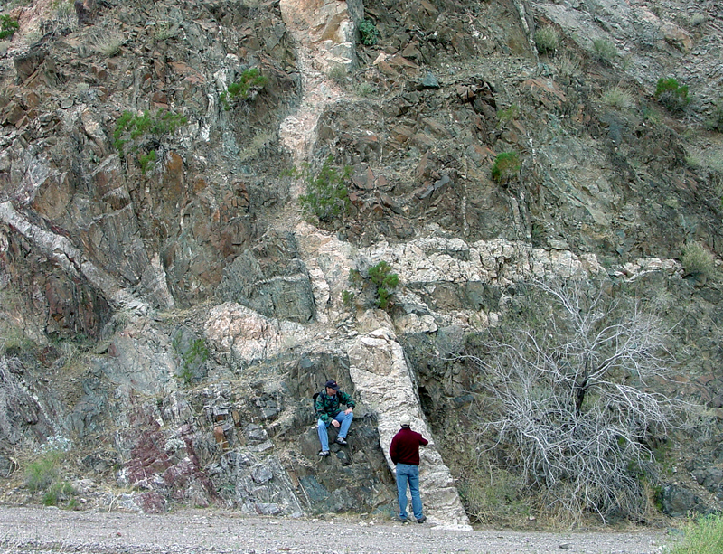
Pegmatite—a coarsely crystalline granite or other igneous rock with crystals several centimeters in length, and sometimes containing rare minerals rich in rare elements such as uranium, tungsten, beryllium and tantalum. Fluids (water, CO2, etc.) dissolved in the magma in the late stages of cooling allow larger crystals to form in pockets within a larger plutonic body. |
| Fig. 8-35. Pegmatite vein in granite. Many important gem minerals and strategic metal-bearing minerals occur in pegmatites (see discussion below with "Igneous Gems"). | |
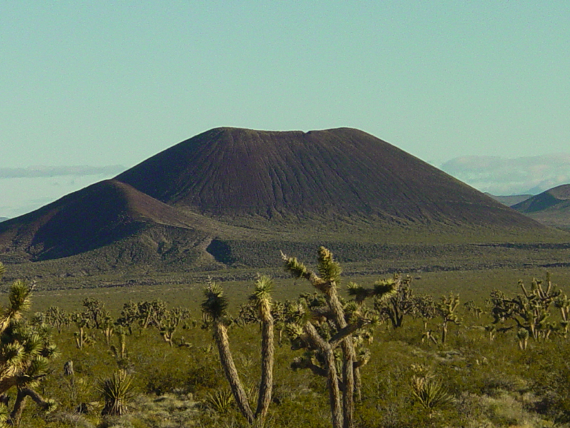
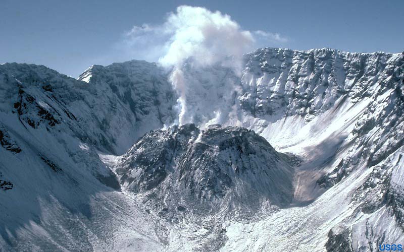
Volcanoes and Volcanic FeaturesVolcanism is any of various processes and phenomena associated with the surface discharge of molten rock or hot water and steam and gases, including features including volcanoes, geysers, and fumaroles.A volcanic cone is a hill or mountain formed by the accumulation of volcanic material around a vent where magma reaches the surface (Figure 8-36). The size and shape of a volcanic cone depends on the volume of material ejected over time, the composition and temperature of the material (lava, rock and gases) vented from the volcano, and the nature of the eruption (explosive or otherwise). There are a variety of different kinds of volcanoes. As discussed above, different plate-tectonic settings produce different kinds of volcanoes (Figure 8-37). Most volcanoes of the world are associated with plate boundaries, either divergent boundaries (spreading centers) or convergent boundaries (volcanic arcs associated with subduction zones). Volcanic eruptions release a variety of material including lava, tephra (ash, cinders and rock fragments), gases, and water. Volcanic eruptions can be gentle venting of fluid lava to catastrophic explosions that blow volcanoes apart and scatter ash and material over large areas (Figures 8-38 and 8-39). |
||||
|


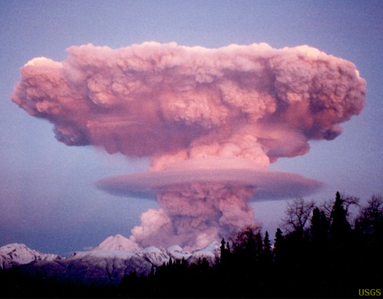
| In general, very hot magmas produce more gentle eruptions. Hot magma eruptions vent gases continuously where they erupt and pour lava on the surface. Very hot lava can flow under the influence of gravity for long distances. Hot magmas occur in association with spreading centers and hotspots. These hot magmas are almost always mafic to ultramafic in composition. Cooler magmas associated with subduction zones tend to be rich in dissolved water and gases. As this magma approaches the surface, the water and gas trapped in the cooling magma escapes producing great pressure that expands explosively. This causes tremendous eruptions of clouds of steam and ash. Most of the material falls to the surface in the vicinity of the eruption piling up to build up tall volcanic cones. These eruptions can occur suddenly and be tremendous, blowing entire mountain-size volcanoes apart, only to be rebuilt by later eruptions. Explosive volcanoes tend to be felsic to intermediate in composition. |


|


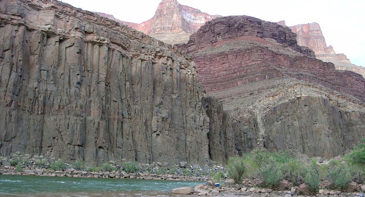
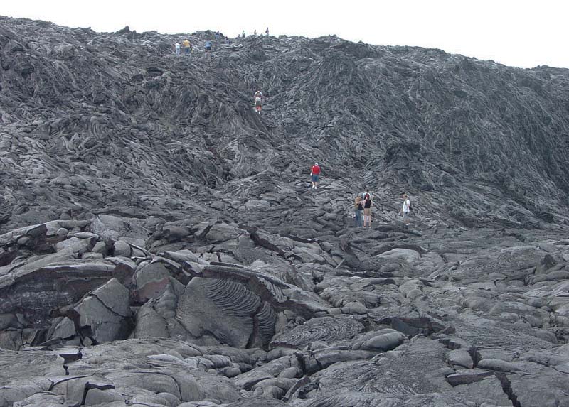
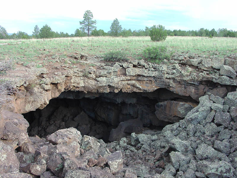
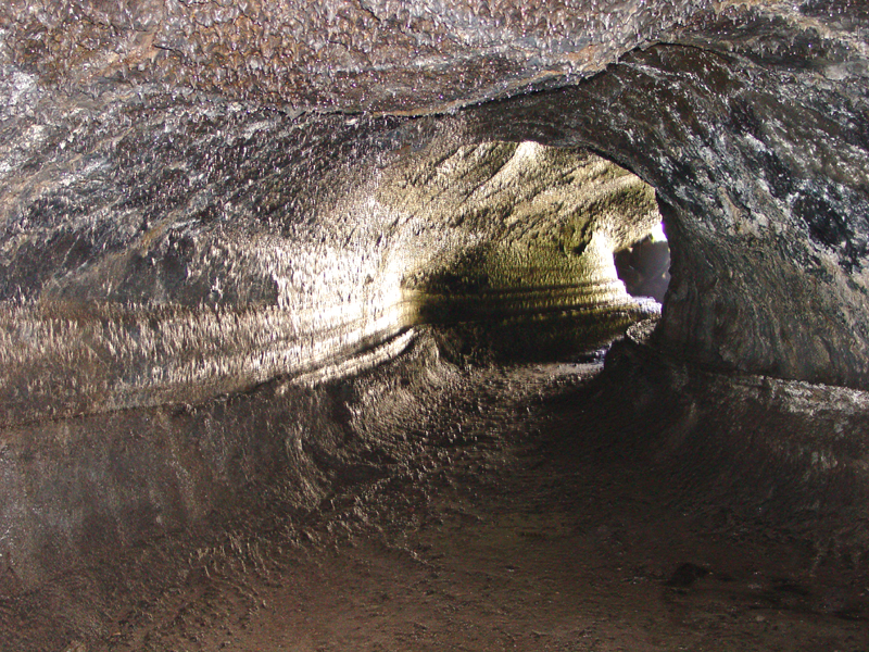
Features Formed From Flowing LavaWhen lava erupts from a volcano, it may pool in the volcano's crater, or spill out and flow downhill under the force of gravity. Lava can travel great distances down canyons or stream valleys before they eventually cool. As the lava flows, it forms a crust on the surface that insulates the lava that continues to flow under the crusty surface. In places, the lava may puncture through the surface of the lava flow and pool or spread on the surface. When the lava it is very hot (such as on the volcanoes on Hawaii), the surface of lava flows will be covered with pahoehoe flow structures (Figure 8-72). As the lava flow cools, the surface crust will be broken into highly angular blocks and fragments that get mixed back in with the slowly advancing flow, producing a'a lava flows (Figure 8-73).As lava flows advance downslope, the surface of the lava flow may rise and fall with the passage of flowing lava below the surface crust. The lava may flow in tube-like passages, and as the flow front moves on or the lava supply diminishes the tubes may drain of their lava leaving behind empty passages. A lava tube is a natural tunnel within a solidified lava flow, formerly occupied by flowing molten lava. (Figures 8-74 and 8-75) |
||||||||
|
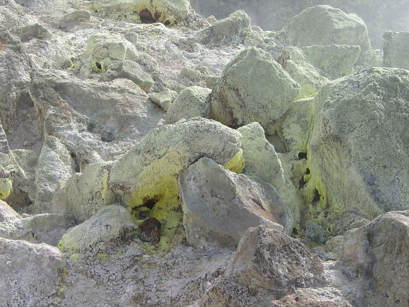
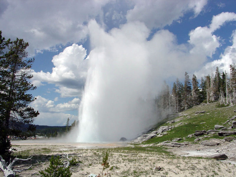
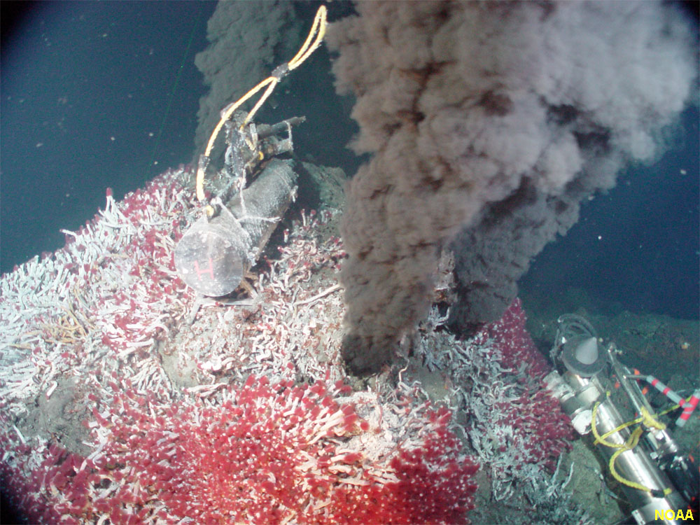
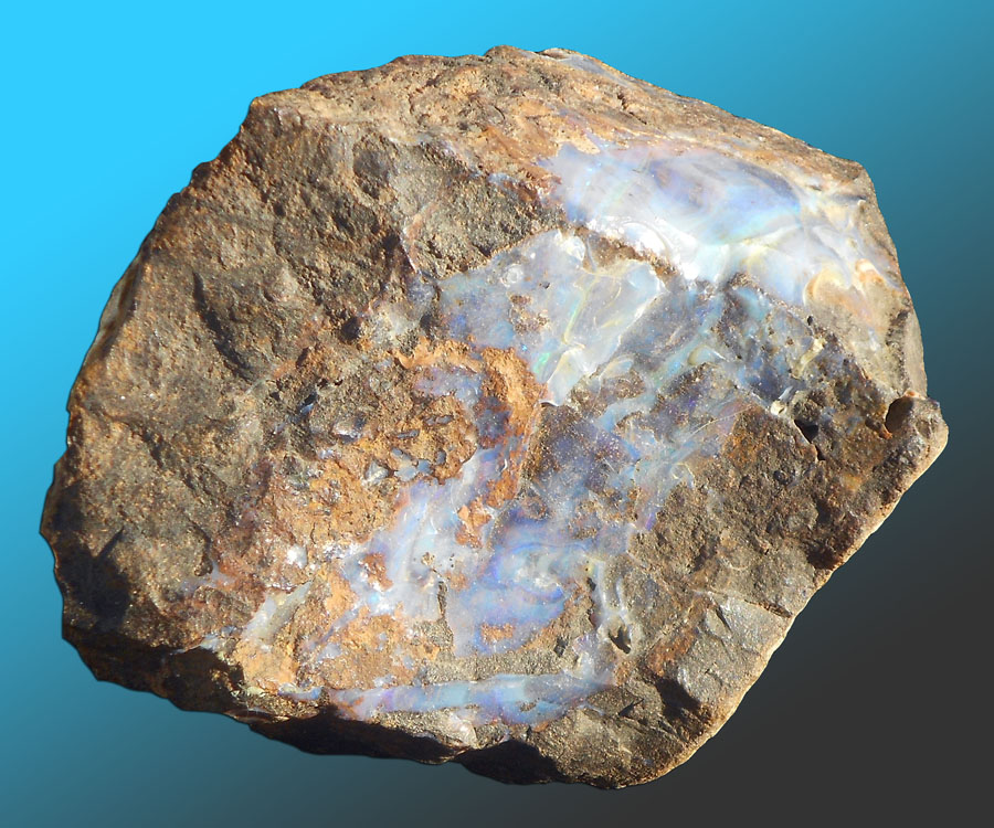
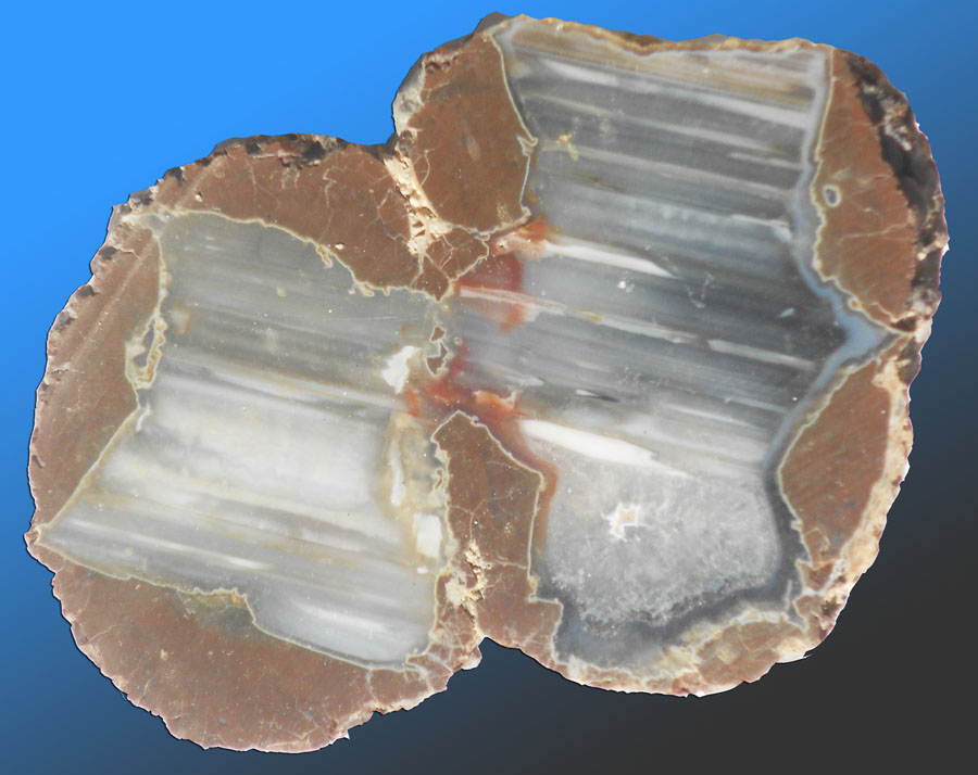
Hydrothermal Features and DepositsIgneous activity releases fluids (water and gases). Heat from hot material also heats the groundwater. As fluids move, they can dissolve and precipitate minerals as the physical and chemical conditions change. Where water (steam) and gases vent at the surface they form fumaroles, hotsprings and geysers.A fumerole is an opening or vent in or near a volcano, through which hot sulfurous gases, steam, and other gases emerge (Figure 8-76). A hot spring is a spring that is produced by the emergence of geothermally heated groundwater from the Earth's crust, and usually defined as spring water warmer than the human body (Figure 8-77). If they are cooler than body temperature but warmer than average air temperature it is called a warm spring. A geyser is a hot spring in which water intermittently boils and erupts, sending a tall column of water and steam into the air (Figure 8-78). Hydrothermal vents occur on the seafloor and are best known from locations on or near mid-ocean ridges. Under the great pressures at the bottom of the ocean water will not turn to steam. Fluids venting from the seafloor have been measured at temperatures hot enough to melt glass! These fluids are rich in a variety of metals and rare elements that precipitate around the vents called black smokers (Figure 8-79). Ancient black smokers and related deposits are associated with many metal ore deposit now found on continents. Hydrothermal veins are fractures in rock that have been filled with minerals (most commonly quartz and/or calcite) precipitated from groundwater or hot fluids of magmatic origin (Figure 8-80). Hydrothermal veins are transitional to cooler setting that those associated with pegmatites (discussed below). Open pocket can also be filled with gem minerals and metals ores including gold, silver, and copper. Most of the world's copper come from large copper porphyry deposits (Figure 8-81). These copper-rich deposits contain precious stone and minerals including azurite, chrysocolla, malachite, turquoise, and others. Cinnabar (mercury ore) also forms in hydrothermal deposits. Hydrothermal deposits are also associated with sedimentary and metamorphic environments. Some gems form after beds of ash and lava settle because the ash is soluble in the hot fluids that may rise from hydrothermal (hot water) vents emanating from below. Hot gases also rise and can carry mineral forming elements. Because the hot water is filled with dissolved minerals, on cooling a precipitation of crystals into spaces in the rock may occur as the hot gases and water rise and cool. Some opals and nodules such as a agate-filled thunder eggs form in this way (Figures 8-82 and 8-83). Geodes are small crystal-filled cavities, usually with hard, typically with spherical or ovoid outer surfaces. Although geodes occur in igneous deposit, most are of sedimentary origin. Any open gas pocket can become a void filled with crystals if conditions are right. |
 |
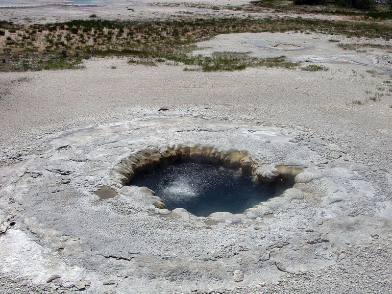 |
| Fig. 8-76. Fumerole with sulfur deposits, Hawaii | Fig. 8-77. Boiling hot spring, Yellowstone, Wyoming | |
 |
 |
|
| Fig. 8-78. Grand Geyser erupting in Yellowstone National Park, Wyoming | Fig. 8-79. Black smokers are hot vent releasing mineral-rich fluids on the seafloor. | |
 |
 |
|
| Fig. 8-80. Quartz veins in North Cascades NP, WA | Fig. 8-81. Copper porphyry from Arizona | |
 |
 |
|
| Fig. 8-82. Precious opal is one variety of opal. | Fig. 8-83. Thunder egg (with banded agate). |
Volcanic HazardsExtremely hot lava tends to release its gases quickly where it erupts, and the extreme heat allows lava to flow long distances, filling in valleys before spreading over the surface. Conversely, lava that is near the point of cooling typically contains a higher percentage of dissolved gases trapped in the molten material. As a result, "cooler" volcanoes tend to release their gases as explosive volcanic eruptions when the molten material reaches the surface. |
|||||
Volcanic features associated with explosive volcanic eruptions:The term tephra is the general term used to describe rock fragments and particles ejected by a volcanic eruptions. Types of tephra include ash, lapilli (pea-sized fragments), cinders (pebble-sized), blocks (cobble- to boulder-sized), and bombs (drip-shaped blobs of lava ejected that remain liquid on the inside with an outer crust when they land).A pyroclastic flow is a dense cloud of very hot ash, lava fragments, and gases ejected explosively from a volcano that typically flows downslope at great speed and with destructive force (Figure 8-84). Volcanic tuff is a name describing rocks composed of volcanic ejecta, such as broken pieces of volcanic glass, phenocrysts, rock fragments, etc., that has been welded together by the heat of an eruption to form a solid rock mass. A lahar is a landslide or mudflow of volcanic materials on the flanks of a volcano. Lahar deposits can often be traced for many miles away from a volcanic source area, following stream valleys and covering flood plains. Some volcanic eruptions can be catastrophic enough to blow volcanic mountains apart and blanket large regions with volcanic ash and cinders, even causing changes to global climates. Massive volcanic eruptions have blanketed large regions on the North American continent throughout geologic history. Massive tephra ash-fall deposits called ignimbrites can be found throughout the Great Plains region from ancient volcanic eruptions that happened as far away as Nevada. Nearly a quarter of world's human population live in regions that could experience moderate to catastrophic effects of volcanic eruptions. |
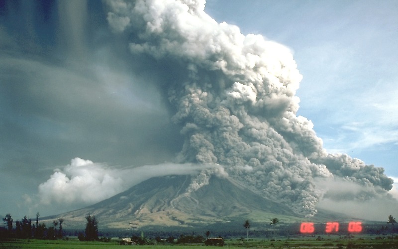 Fig. 8-84. Pyroclastic flow descending the Mayon Volcano, Philippines 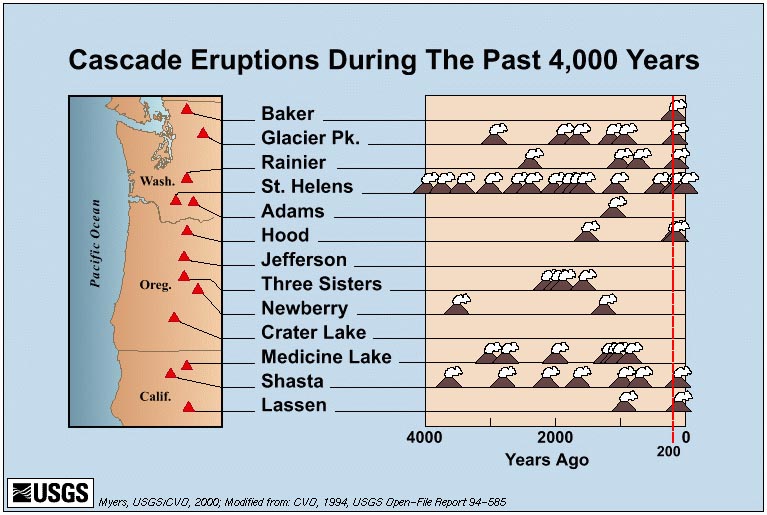 Fig. 8-85. Cascade Range volcanic eruptions of the past 4,000 years |
||||
|
|||||
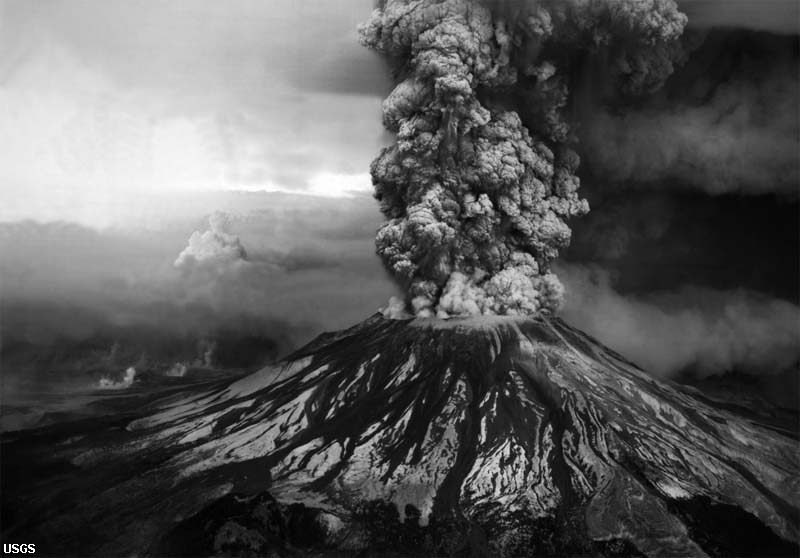
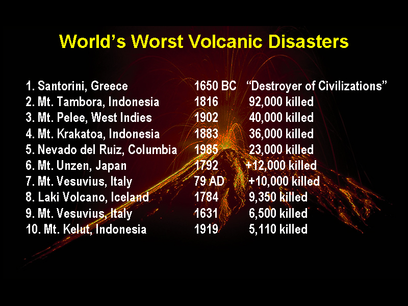
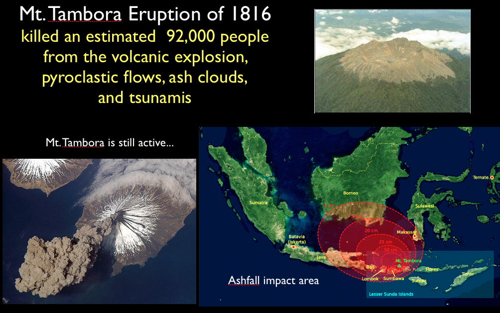
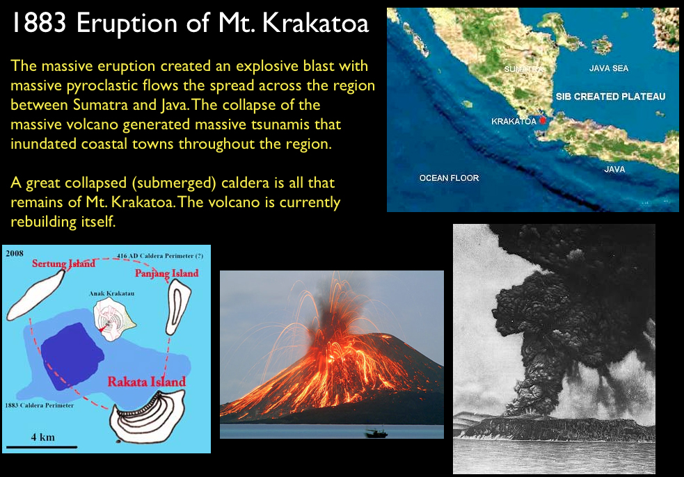
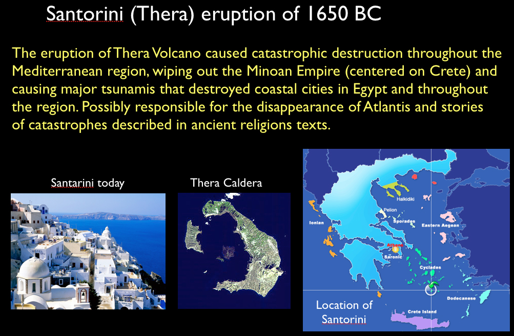
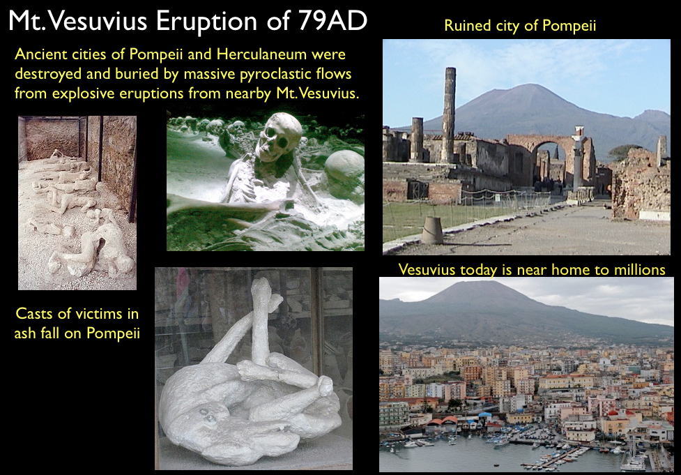
Volcanic Disasters in World HistoryBad days when you might want to say "I hate when that happens." Volcanic disasters have significantly impacted civilizations of the past and have left their mark on the cultural and religious heritage that still exists today, and without doubt, will do so in the future.Below are some highlights of some of world's worst volcanic disasters. Massive volcanic eruptions are destroyers of civilizations. Volcanic eruptions produce earthquakes, massive hot ash clouds (pyroclastic flows), generate tsunamis, and can even change the climate lasting for decades, and much more (Figure 8-90). Figures 8-91 to 8-97 highlight some the biggest to impact humanity in historic times, and there were probably many much worse in prehistoric times. Some of the most notorious in history include the eruption of Tambora in 1816, Krakatoa Volcano in 1881, and the Mt. Pelee in 1902. Great ones in ancient history including the eruption of Mt. Vesuvius in Italy, and perhaps the greatest, the great eruption on Thera (what's left is now Santorini) that is considered to have wiped out the Minoan Civilization and reeked havoc on ancient Egypt and other cultures in the Mediterranean region. |
|||||||||||||||
|
|||||||||||||||


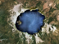
The Toba Super EruptionAn Event That Almost Wiped Out HumanityThe Toba catastrophe theory is a body of knowledge that suggests that the human species (and many others) were almost wiped out by a major volcanic eruption. About 75,000 years ago, in the region around present day Lake Toba in Sumatra, Indonesia, one of the largest know volcanic eruptions occurred. For size scale, the Toba Caldera (crater and lake) is about the same size as the San Francisco metropolitan region (Figure 8-98). The Toba eruption is estimated to have been 100 times larger that the largest eruption in historic times— the eruption of Mount Tambora in Indonesia in 1816, an eruption that cause the Year Without a Summer in the Northern Hemisphere (Figure 8-99). The Toba catastrophe theory suggests that the massive ash clouds and noxious gas emission from this eruption may have blanketed the planet with volcanic ash dust. The eruption may have cause about a 1,000 year global cooling event that would have altered environments and ecosystems all around the world. |
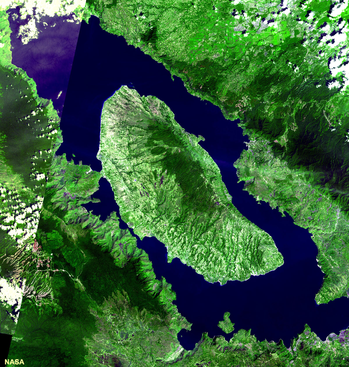 Fig. 8-98. The Toba Caldera in Sumatra erupted about 75,000 years ago and may have severely impacted life on Earth. |
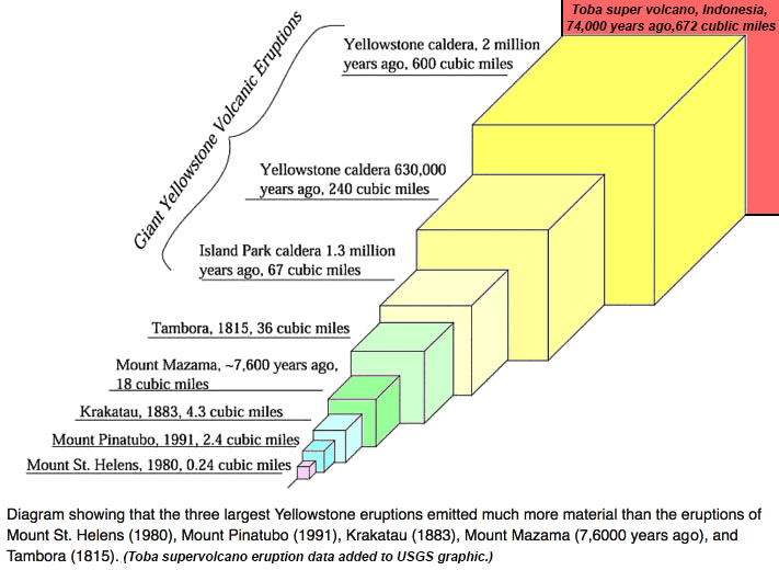 Fig. 8-99. Comparison of the Toba eruption to Yellowstone's eruptions and other major eruptions in recent Earth history. |
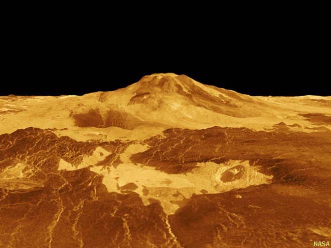
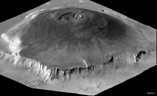
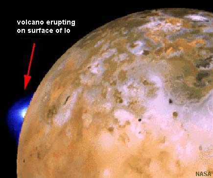
Igneous Activity On Other Planets And MoonsEarth is not the only place where volcanism is known to occur. Volcanism occurs on other planets and moons (NASA images). |
||||||||
|
Economic Value of Igneous Rock ResourcesMost of the world's most precious metals, rare-earth elements, and gemstones come from rocks of igneous origin. Most gold, silver, copper deposits around the world are associated with igneous source rocks, or the sedimentary placer deposits derived from them. Massive copper porphyry deposits are probably strategically the among the most important metal deposits in the world (because of the abundance and diverse uses of the metal, see Figure 8-81).Gemstones From Igneous RocksGems are minerals that can form under limited physical and chemical environments. In some cases, these may be only igneous settings. However, some minerals, quartz as an example, can form in a variety of settings, igneous, sedimentary, and metamorphic. Is a discussion of two (of many) settings of how gems form and how they occur. Below is a chart showing selected gems formed in igneous settings. |
The Igneous Origin of DiamondsDiamonds are a rare occurrence on the surface of the planet because it takes extremely hot and high pressure conditions to create them. Physical and chemical conditions where diamonds form only exist in the mantle, nearly 70 miles down or more. In that environment in the upper mantle, diamonds may be a common mineral! It takes incredible events, nothing that has ever been witnessed in historic times, to bring diamonds to the surface. Diamond deposits around the world (that have any economic significance) are associated with volcanic features called diatremes (Figure 8-104). A diatreme is a long, vertical pipe formed when gas-filled magma forces its way through the crust to explosively erupt at the surface. Kimberlite a special kind of intrusive igneous rock associated with some diatremes that sometimes contain diamonds. Kimberlites are typical coarse grained rocks with an bluish in color. Diamonds are xenoliths carried up from deep sources in the mantle, and often occur in association with other gem minerals including garnet, spinel and diopside. Most economically significant diamond deposits occur in ancient rocks (Precambrian age), but have been discovered on all continents. Because diamonds are so hard, they survive torturously-long histories, recycled through sedimentary and metamorphic environments without being destroyed. As a result diamonds have been found almost everywhere as very rare, isolated discoveries. Diamonds of microscopic size have been discovered in meteorites and asteroid impact sites, and in some metamorphic rocks. They are most extensively mined from kimberlite pipes or from alluvial gravels derived downstream from diamond source areas. It should be noted that most diamonds are not of gem quality, but those that are not gems are used for industrial purposes. |
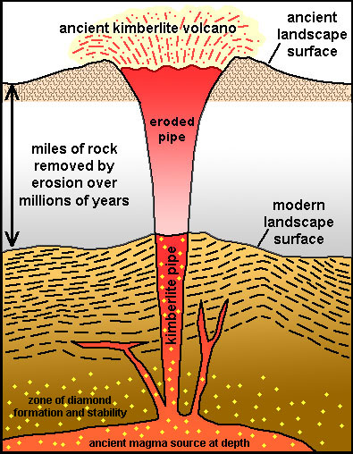 Fig. 8-104. Diamond-bearing kimberlite pipes are diatremes that originate in the mantle. |
PegmatitesPegmatite is a coarsely-grained crystalline igneous rocks with interlocking crystals typically several centimeters in length (or larger, including the world’s largest crystals, some larger than 10 meters in length). many exotic and important minerals, including many gemstones, are found in them (Figures 8-104 to 8-109).Mineralogy: Most pegmatites are granitic in composition, having granite’s constituent minerals quartz, feldspar (Na-plagioclase and orthoclase) and mica, commonly muscovite. Less common are gabbroic pegmatites—a gabbro with very large crystal grains of amphiboles, biotite, and some pyroxenes. Occurrence: Pegmatite typical form as masses in igneous dikes and veins. They are most common along the margins of large igneous intrusions, especially in regions associated with batholiths. Some pegmatites apparently form from very fluid remnants of cooling magma with incompatible elements that are driven off of the main cooling plutonic rock body. An aureole zone is where host rocks show the effects of being nearby cooling large intrusions. Fracture formed in wall rocks surrounding a nearby intrusion can be flooded with late-stage magma and high-pressure fluids derived from magma that are rich in volatile components including water, CO2, and other gases. The volatile components both lower the temperature that mineral can form, but also enhance diffusivity (the ability for elements to move around within a fluid to interact with crystal nucleation sites). This diffusivity allows large and rapid crystal growth—allowing minerals to separate into pockets, some with rare and unusual compositions. These late stage fluids can be enriched in the elements necessary for important gems. Not all pegmatites form the same way. Pegmatites frequently occur in association with aplite dikes and veins (Figures 8-109 to 8-110). Aplite is a light-colored granitic rock composed of quartz and feldspar with sugary texture. Pegmatites occur in pod-shaped mass, usually as small pods to long linear zones, in some rare cases hundreds of feet in size and thickness. Some pegmatites may contain open pockets (called vugs) that are typically surrounded by well-formed crystal masses radiating into the open voids. Some pegmatites are best described as metamorphic in origin, formed as rocks rich in fluids only begin to melt and separate from host rocks into isolated pockets and veins. Economic Value: Gem minerals found in pegmatites include: apatite, beryls (including emerald), cassiterite, corundum (sapphires), feldspars (including aquamarine and perthite), fluorite, garnet, lepidolite quartz varieties (crystal, rose, and smoky), spodumene, topaz, and tourmaline. Pegmatites sometimes containing rare minerals rich in uncommon elements, including important rare-earth elements. Pegmatite ore around the world have been mined for such economically strategic elements, primarily for beryllium and lithium, but also aluminum, bismuth, boron, cesium, molybdenum, niobium, potassium, tantalum, thorium, tin, tungsten, and uranium. |
Fig. 8-105. Pegmatite with schorl (black tourmaline) in quartz and orthoclase feldspar from Black Hills, South Dakota.  Fig. 8-107. Pegmatite with watermelon tourmaline. minerals: pink (elbaite) and green (liddicoatite) from from San Diego County, California 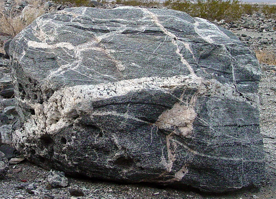 Fig. 8-109. A boulder of with aplite and pegmatite veins in Death Valley National Park, California. |
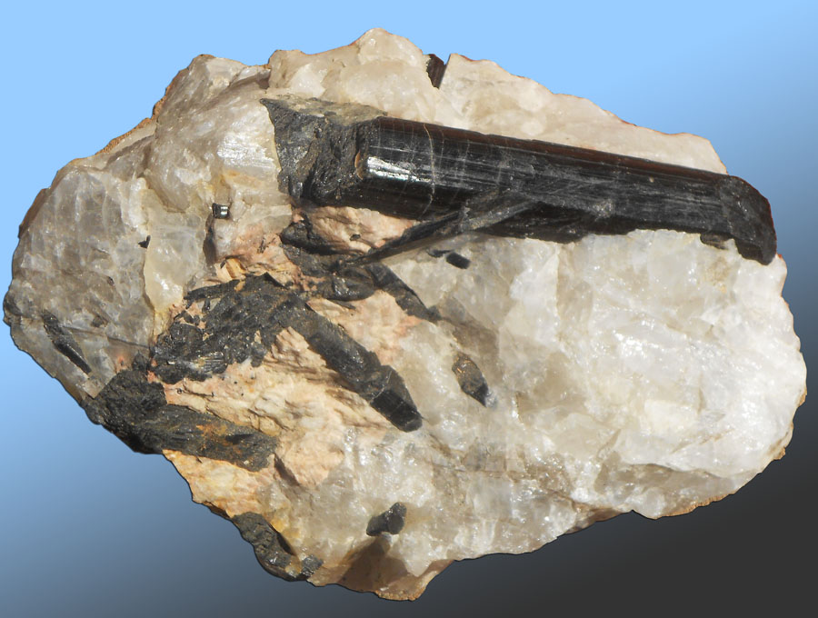 Fig. 8-106. Pegmatite with schorl (black tourmaline) in quartz and orthoclase feldspar from Black Hills, South Dakota. 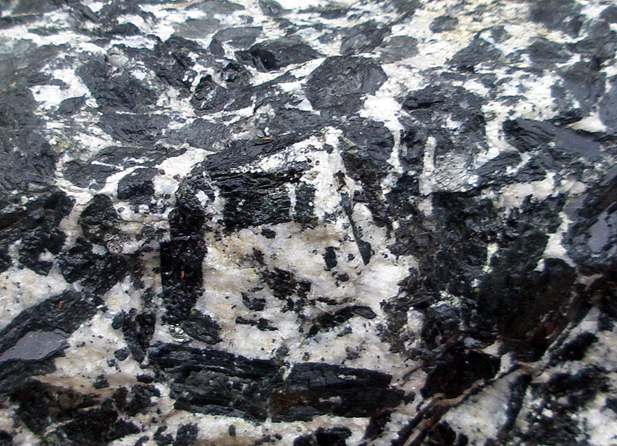 Fig. 8-108. Gabbro pegmatite (crystals of amphibole and plagioclase) from Aromas Quarry, Monterey County, CA  Fig. 8-110. Pegmatite and aplite dikes and veins in granitic rocks on Kehoe Beach, Point Reyes National Seashore, California Fig. 8-110. Pegmatite and aplite dikes and veins in granitic rocks on Kehoe Beach, Point Reyes National Seashore, California |
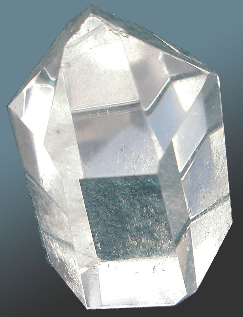
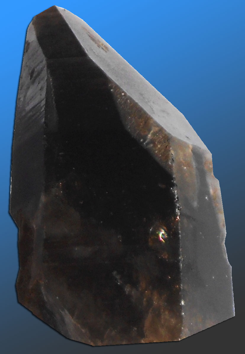
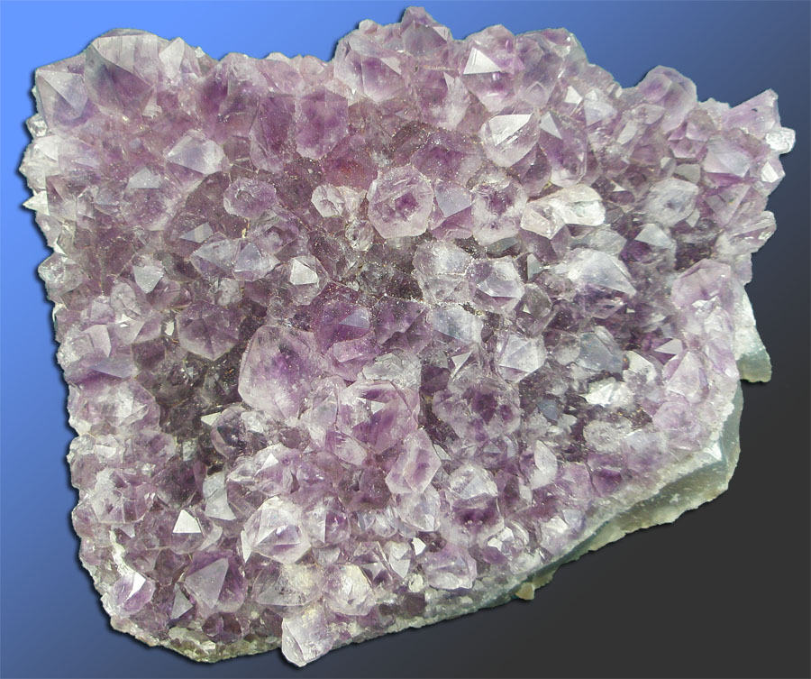
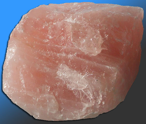
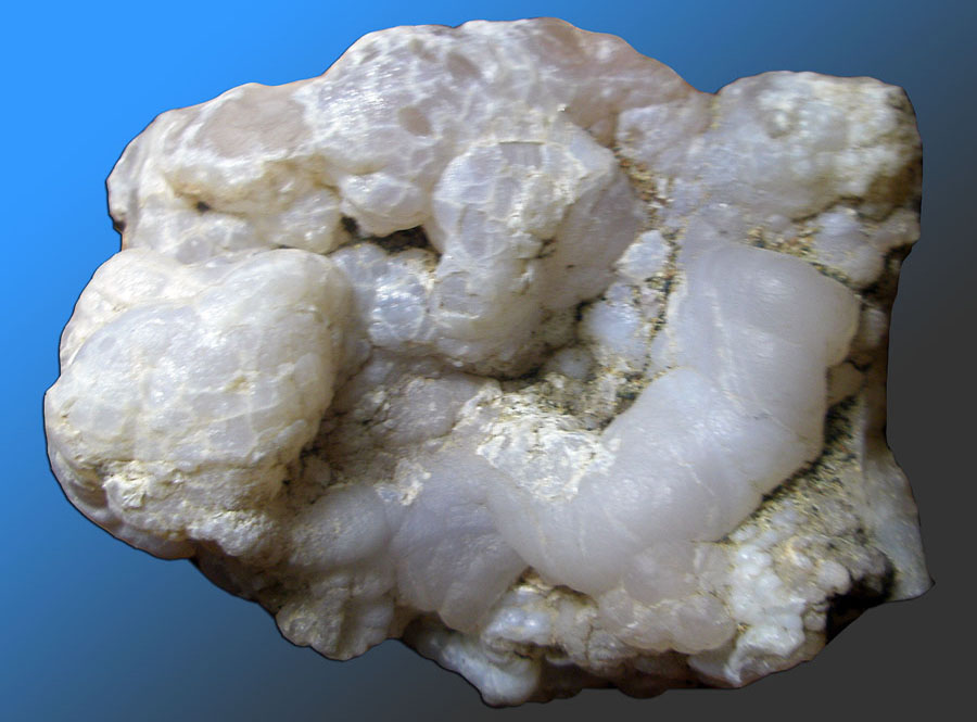
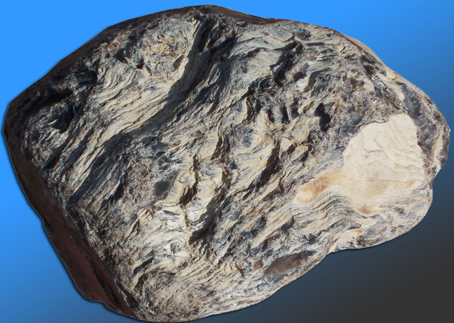
Many Gems of Igneous Origin Are SilicatesA silicate is a mineral that contains silica (SiO2) within its crystal structure. Silica content refers to the total content of SiO2 in a rock or mineral. For instance, a rock composed entirely of albite (a feldspar with the chemical formula NaAlSi3O8) has a silica content of 77%. Pure quartz (mineral) consists of 100% silica (Figure 8-111). Although silicate minerals are abundant and important not all that many silicates are gems. Gem minerals that are silicates include varieties of beryls (including emerald), feldspars, olivine (including peridote), quartz, garnets, topaz, tourmalines, and others. A lot of gems, even in of silicate family, have exotic elements. These exotic elements, such as beryllium, boron, lithium, chromium, vanadium, and zirconium need to be concentrated by changing physical and chemical conditions associated with the molten material and fluids that form them. So gem formation often requires unusual geologic circumstances. Sometimes water-rich hot fluids generated from the cooling molten material and rock separate from the main magma and bring with them the exotic elements that do not easily fit into the common silicate mineral crystal structures (that includes ferromagnesian silicates, quartz, feldspar, mica, etc.).Quartz is one of the most abundant minerals in the crust. It is the most abundant gem so all varieties are considered semiprecious. Quartz has a variety of forms that are used a gems or precious stones. Pure, clear quartz is called rock crystal (Figure 8-111). The combination of trace impurities and exposure to radiation give other varieties of quartz their color. Smoky quartz gets its dark color from silicon atoms set free in the crystalline structure of quartz (Figure 8-112). Amethyst, citrine, and rose quartz have traces of iron and other metals in the crustal structure and are also discolored from natural radiation exposure in the environments where they form (Figures 8-113 and 8-114). Heating colored varieties of quartz can undue the effects of radiation exposure and alter the color of the mineral. Most commercially sold citrine gems are actual heat-treated amethyst or smoky quartz. Quartz has different crystal structures. The most common, called α-quartz, is stable in the pressures and temperatures of the surface environment. At at 573 °Celsius it undergoes a reversible change in crystal structure to form β-quartz. Over time, if conditions are right, β-quartz converts to α-quartz. Silica (Si02) has a polymorph (an alternative crystal structure) called moganite. Quartz and moganite combine in microcrystalline size to form the mineral chalcedony (Figure 8-115). Different varieties of quartz combine to form different kinds of stones that show contrasting bands or patches of color. These include agate, sard, onyx, carnelian, heliotrope, and jasper. However, most of these forms also occur in sedimentary or metamorphic settings, and not entirely igneous. For instance, fossil wood is frequently preserved as brightly colored varieties of quartz and is abundant in deposits rich in volcanic ash (Figure 8-116). Chemical interactions between the volcanic ash, groundwater, and wood buried in the volcanic ash replace the organic tissue of the wood with silica (or various forms of silica and other minerals). |
Quartz varieties with different trace impurities | |
 |
 |
|
| Fig. 8-111. Rock crystal is pure quartz. Quartz is one form of silica (SiO2) | Fig. 8-112. Smoky quartz is dark from radiation exposure | |
 |
 |
|
| Fig. 8-113. Amethyst gets it color from both traces of iron and radiation exposure over time. | Fig. 8-1143. Rose quartz gets its color from traces of titanium, iron, or manganese. | |
 |
 |
|
| Fig. 8-115. Chalcedony is a variety of microcrystalline quartz with a botryoidal appearance. | Fig. 8-116. Fossil wood can be wood replaced by silica and other minerals derived from volcanic ash. | |
Links go to Smithsonian Institution's "Gem Gallery" website |
||||||||||||||||||||||||||||||||||||||||||||||||||||||||||||||||||||||||||||||||||||||||||||||||||||||||||||||||||||||||||||||||||||||||||||||||||||||||||||||||||||||||||||||||||||||||||||||||||||||||||||||||||||||||||||||||||||||||||||||||||||||||||||||||||||||||||||||||||||||||||||||||||||
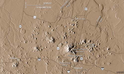
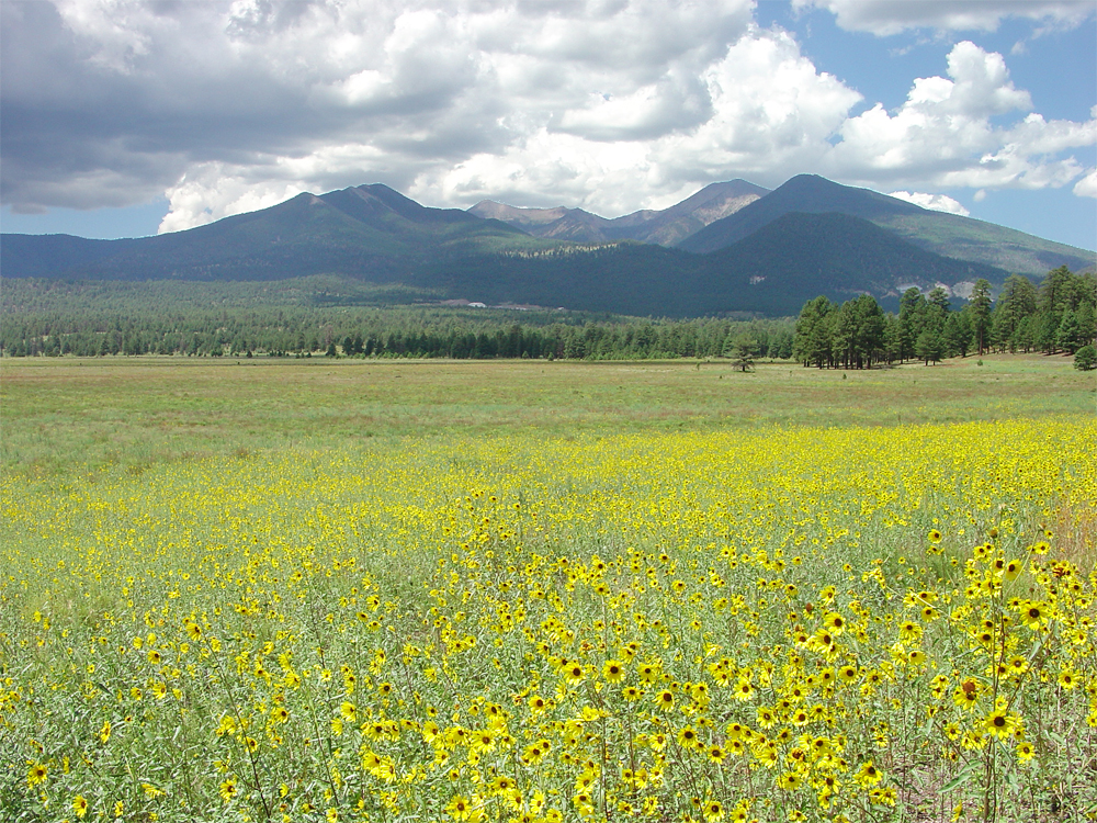
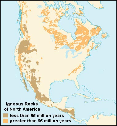
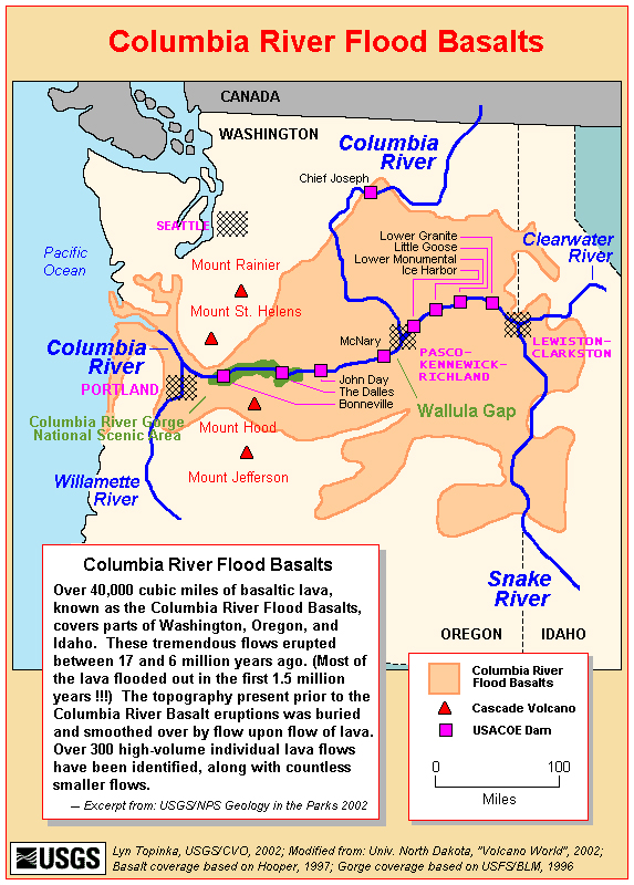
Volcanic Rocks In the United StatesVolcanic rocks are exposed in large areas or regions across the United States, particularly in the western United States. Figure 8-117 is a map showing areas where volcanic rocks are exposed in North America. The largest region is associated with the Columbia River Basalts that extend from the coastline of Oregon and Washington eastward across parts of Idaho to the great Yellowstone Hotspot supervolcano region of northwestern Wyoming. Active and recently active (in geologic terms) volcanoes and volcanic fields occur in Arizona and southern Utah (around Flagstaff, AZ and extending north of the Grand Canyon). There are many young and active volcanoes in the Cascades Range and the long volcanic arc system that extends northward through coastal Canada, southern Alaska and through the Aleution Islands region (this is all subduction zone-related volcanism). There are also recently formed volcanoes in southern California in the Mojave region and south end of the Salton Sea, and in New Mexico associated with the greater Rio Grand Rift valley. These regions are described on the Regional Geology of the United States website. |
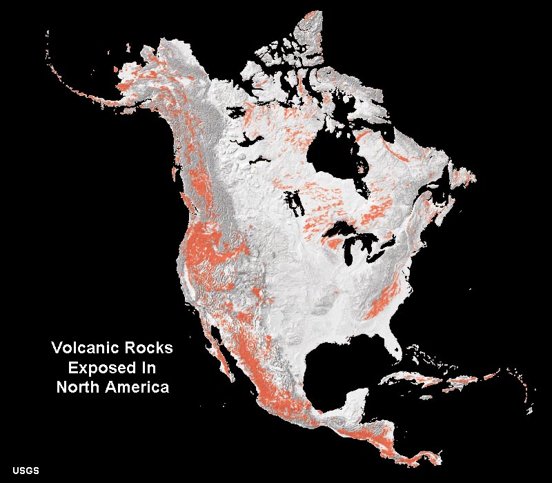 Fig. 8-117. Volcanic rocks exposed in North America. |
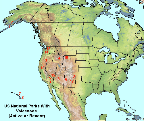
US National Parks With Volcanoes and Igenous Rock FeaturesBelow is a list of selected national parks and monuments that display volcanic features or ancient eroded remnant of igneous rock features. |
|
National Parks and Monuments With Volcanoes
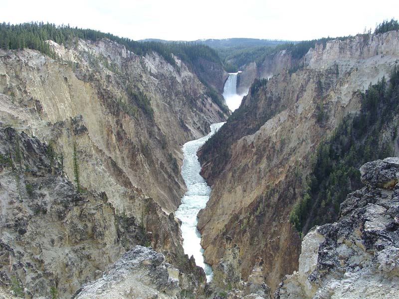
Aniakchak National Monument & Preserve, AK - 1 |
|
| Nearly all recent or active volcanic regions are associated with tectonically active regions: continental rifting, subduction zone volcanoes, and hotspots. | |
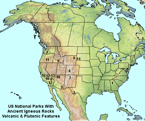
National Parks With Ancient Igneous Rocks
Arabia Mountain
National Heritage Area, GA - 1 |
|
The USGS Volcano Hazards ProgramThe U.S. Geological Survey Volcano Hazards Program has the responsibility of monitoring volcanic activity throughout the states and territories. USGS Scientists are tasked with the study of volcanoes and volcanic regions that are currently active or have show evidence of being recently active (in geologic terms, recorded hundreds to thousands of years). The USGS conducts volcano assessments, monitoring, eruption forecasting, and provide expertise and training for evaluating volcanic hazards here in the United States and abroad to greatly expand global capabilities that mitigate the impacts of volcanic hazards They monitor seismic activity, volcanic gases escaping from the ground, and changes in the ground surface, possibly related to the movement of molten material beneath the surface, and more.The USGS operates five U.S. “Volcano Observatories” associated with research centers in the western United States. Each observatory focuses on the volcanic and associated geologic activity associated with different regions of the country. USGS Also works with other countries and organizations around the world to monitor volcanic activity including: |
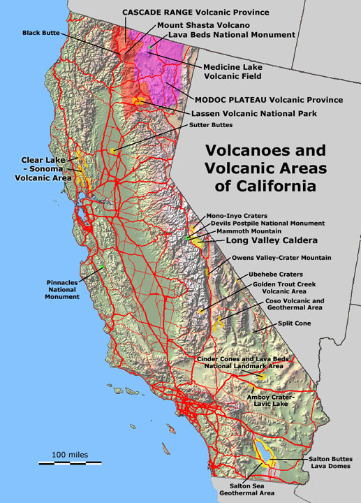
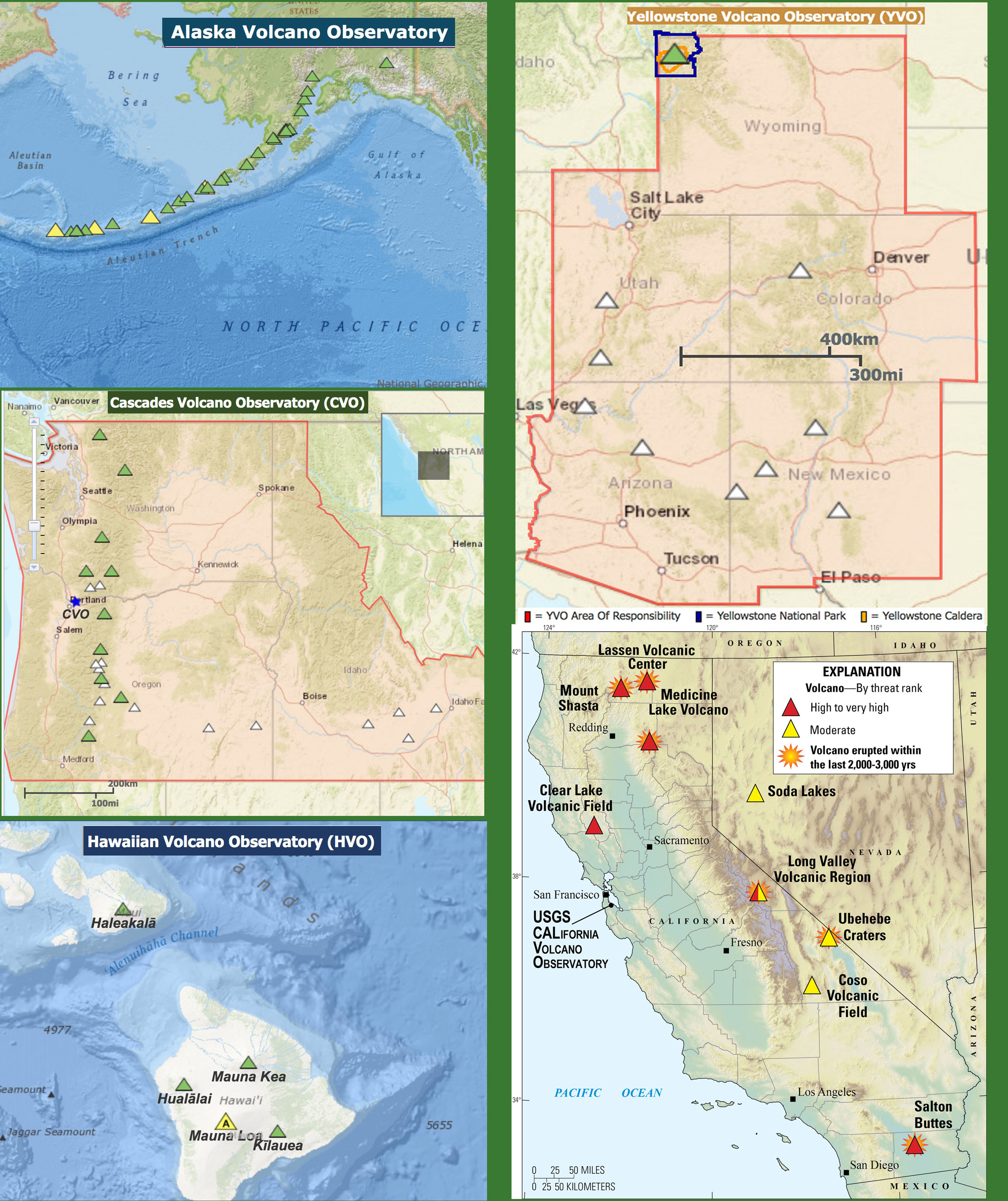 USGS Volcano Observatories maps showing location of volcanoes and volcanic area being monitored. 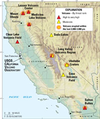 Volcanic hazard alert map for California's active and recently active volcanic areas. “At least ten eruptions have taken place in the past 1,000 years, and future volcanic eruptions are inevitable.” (from California’s Exposure to Volcanic Hazards) |
| Smithsonian Institution, National Museum of Natural History, Global Volcanism Program The SI's Global Volcanism Program is devoted to a study Earth's active volcanoes and their eruptions during the last 10,000 years. Their mission is to document, understand, and disseminate information about global volcanic activity. They maintain databases and reporting about the eruptive histories of volcanoes since the program started in 1968. |