
Oceanography 101 |
Return to class home page |
Chapter 3 - Structure of the Earth |
| This chapter reviews the major concepts of the structure of the Earth and describes the dynamic processes associated the formation of distinct layers within the earth. This is essential information to understand plate tectonics (discussed in Chapter 4). Plate Tectonics Theory explains how the Earth’s surface is broken up into
large plates of rock whose slow movements create earthquakes, volcanoes, and
mountains, changing the way the Earth looks over geologic time. While much has been discovered about the character and natural resources of our planet since the time of Christopher Columbus's first voyage, little was know about the internal character of the Earth until the Cold War era following World War II. Although studies of the internal structure of the earth were first reported in the late 19th century using seismic wave data from great earthquakes, it was the data from testing, spying, and verification of underground nuclear explosions that provided a clearer, more detailed picture of the internal structure of our planet. The earth is composed of several zones, including a central core, a mantle, and a crust (Figure 3-4 and 3-5). Oceans (hydrosphere) and atmosphere rest on the surface of the crust. All parts are held together and have their character based on the force of gravity, their chemical composition, and largely how they formed and changed through geologic time. These same factors apply to other planets and moons as well. The solid earth has a central core (both solid & liquid), a mantle (mostly solid though capable of slow flow by heat convection), and the crust (solid). The appearance of the world as we see it today is a result of the accumulative effects of all geologic processes that have happened in the past. Some of these processes occur rapidly (such as volcanic eruptions, earthquakes, great storms and flood, and occasional asteroid impacts). However, most features we see on the landscape or in a region (or larger features like continents) involve processes that are far grander, operating both near and deep below the surface, and taking place gradually over long periods of time (in spans measured in millions to hundreds-of-millions of years). For instance, the coast lines of northwest Africa and the eastern United States are currently moving apart at a rate of about 2-4 inches a year. However, about 200 million years ago the two continents were joined together before the opening and formation of the Atlantic Ocean basin! Plate tectonics theory helps explain most of the processes and grand landscape features we observe around the world today, both on land and beneath the oceans. |
Click on small images for a larger view throughout this website. |
 Fig. 3-1. Nearly all geologic processes observed on Earth fit in some way into Plate Tectonics Theory. 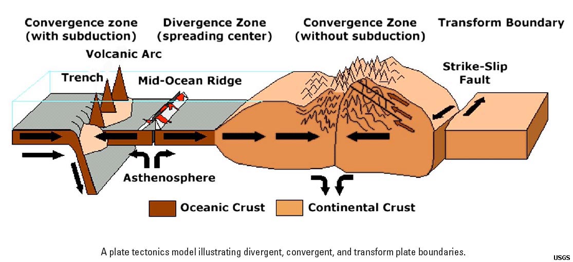 Fig. 3-2. A simplified model of plate tectonics showing types of lithospheric plate boundaries. |
The AtmosphereThe atmosphere is a gaseous mass or envelope surrounding the Earth, and retained by the Earth's gravitational field. The Earth's atmosphere is subdivided into levels:
|
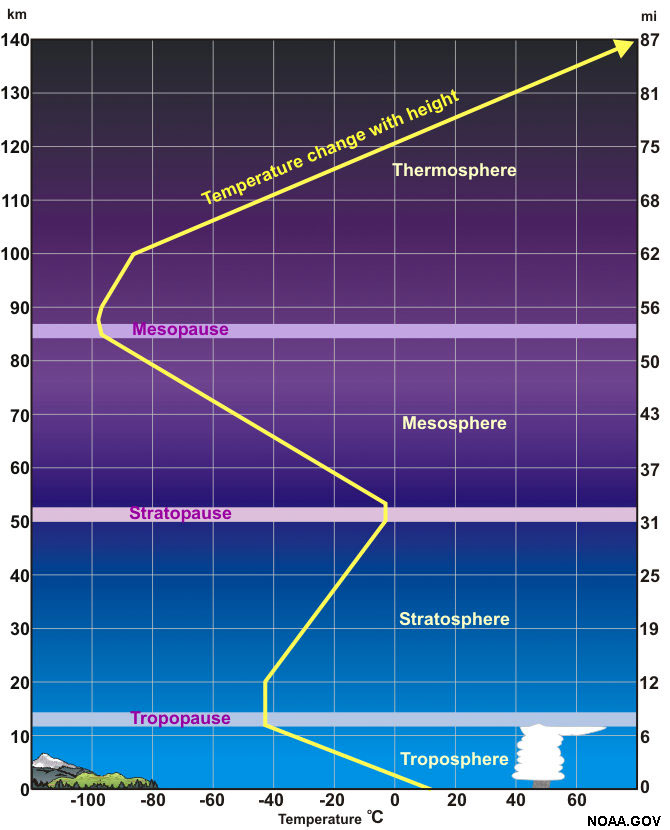 Fig. 3-3. Structure of the Earth's atmosphere. |
The Solar Wind Impacts the Upper AtmosphereThe solar wind is a stream of energized, charged particles (mostly electrons and protons) flowing outward from the Sun's upper atmosphere. The ionized particles are released into space from the Sun's corona and by solar mass ejections (prominences and flares). The solar wind moves through solar system at speeds roughly 500 miles per second (800 km/sec); about 10 days from Sun to Earth) and can reach temperatures of about 1 million degrees (Celsius). The solar wind is what blows a comet's tail away from the bodies of comets as they go through the solar system. Estimates suggest the Sun loses the equivalent of “one Earth mass” about every 150 million years (which isn't much considering the size and mass of the Sun). Large corona ejections from the Sun’s surface result in solar storms that frequently impact Earth and other planets. Solar storms associated with coronal mass ejections can interfere with radio communications, cause damage to satellites, and impact electrical transmission lines and facilities (resulting in power outages). During strong solar storms long lines of metal (like electrical power lines, pipelines, and railroad lines in northern regions can overload with electrical charges which and spark to nearby objects and have been reported to have started brush fires. Because massive solar ejections can be observed, the possible impacts of solar storms can be predicted. |
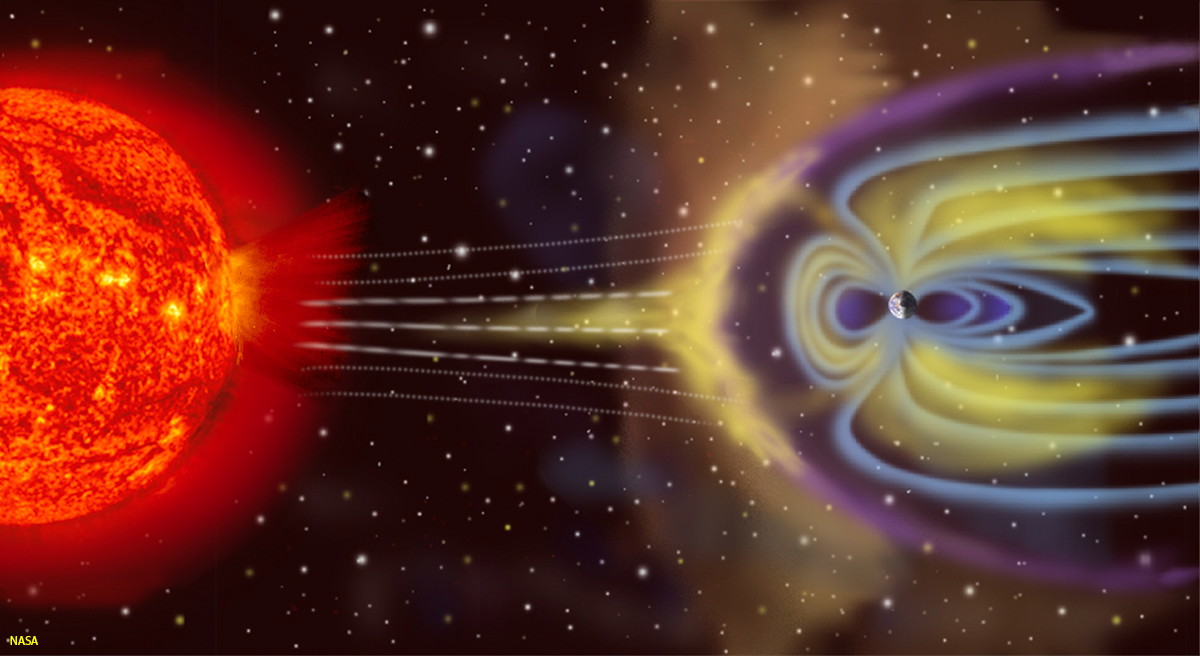 Fig. 3-4. Coronal mass ejections result in the solar wind which is deflected and captured by the Earth's magnetic field that extends int space (the magnetosphere). Fig. 3-4. Coronal mass ejections result in the solar wind which is deflected and captured by the Earth's magnetic field that extends int space (the magnetosphere).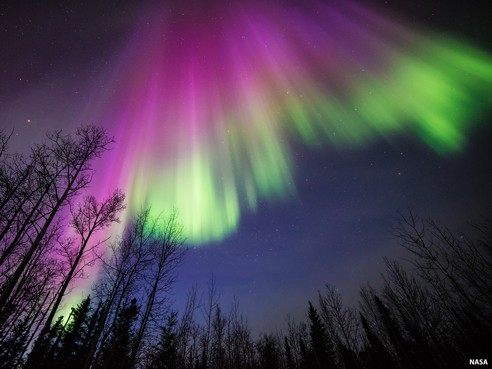 Fig. 3-5. The aurora borealis are streaming light displays lights in the northern hemisphere. Fig. 3-5. The aurora borealis are streaming light displays lights in the northern hemisphere. |
Hydrosphere and CryosphereThe hydrosphere includes all the waters on the Earth's surface, such as oceans, lakes, rivers, streams, and groundwater. 97% of all water on earth is seawater (discussed in Chapter 7).The cryosphere is the frozen water on Earth including glaciers, sea ice, snow, freshwater ice, and frozen ground (permafrost). The hydrologic cycle illustrates the movement of water through the hydrosphere and cryosphere. The movement of water and ice erodes the land surface and provides ocean basins with sediment. Dissolved materials become the salt in seawater. Salts in seawater are concentrated as water evaporates and later falls as precipitation, with most of it falling back into the ocean. The rest falls on land and becomes ice, runoff, groundwater, or is absorbed and released by living things, mostly plants. |
 Fig. 3-6. The hydrologic cycle illustrates the movement of water through the hydrosphere and cryosphere. |
The Biosphere?The term biosphere is the regions of the Earth occupied by living organisms. Life as we know it requires liquid water. So far, a biosphere is only known on Earth. Earth's biosphere encompasses the land's surface, oceans and surface waters (including the seabed in the deepest parts of the ocean basins). Life is found in the lower atmosphere (considering birds, flying insects, and wind-blown pollen and microbes), and deep underground,such in caverns, and even deeper where microbes have been found in groundwater and in porous spaces between mineral grains of solid rock deep in the subsurface. Microbes can tolerate the near boiling temperatures and extreme acidic conditions of hotsprings and thermal pools in Yellowstone National Park and other hydrothermal settings around the world. Microbes are found consuming and degrading oil reserves in petroleum reservoirs deep underground. One of the most sought goals in space exploration is to find evidence of biospheres on other planets and moons. |
Subdivisions of the Structure of the Solid EarthThe Earth consist of several parts: a core, a mantle, and a crust. Other planets and moons in our Solar System share some of these characteristics:
Other rocky planets and moons have also cores, mantles, and crusts, hydrospheres, and atmospheres. So far, only Earth is known to have a biosphere. |
 Fig 3-7. The asthenosphere is a part of the upper mantle that behaves in a more fluid-like manner than the overlying lithosphere. The lithosphere is cooler, and behaves in a more rigid or brittle manner. The lithosphere includes uppermost part of the mantle and overlying crust. It is the region where all earthquakes take place. Rocks in the asthenosphere are hot and will deform rather than fracture under pressure. |
Layers Of the Earth As Defined By Physical PropertiesWith increasing depth, Earth’s interior is characterized by gradual increases in temperature, pressure, and density.Depending on the temperature and depth, a particular Earth material may behave like a brittle solid, deform in a plastic–like manner, or melt and become liquid. Figure 3-8 illustrates the structure of the Earth highlighting the physical properties of the different layers. Lithosphere (sphere of rock)The term lithosphere is used to describe the rigid outer part of the Earth, consisting of the crust and upper mantle. Compared with other layers of the Earth, the lithosphere is a relatively cool, rigid shell and averages about 60 miles (100 km) in thickness, but may be about 155 miles (250 km) or more thick beneath the older portions of the continents. The lithosphere is broken up into moving plates, and the movements of these plates are responsible for all the large-scale features observable on the surface—including ocean basins, continents, and mountain ranges.Asthenosphere (weak sphere)The term asthenosphere refers to a semi-fluid layer beneath the lithosphere (within the upper mantle), between about 60 to 400 miles (100-650 km) below the outer rigid lithosphere (oceanic and continental crust) forming part of the mantle. The asthenosphere, although solid, is very hot and is thought to be able to flow vertically and horizontally, enabling sections of lithosphere to undergo movements associated with plate tectonics. Geologist use the term plastic to describe how hot solid materials, including rocks, can deform and flow slowly.Mesosphere (or Lower Mantle)This region is a rigid layer between the depths of about 400 to 1800 miles (650 km and 2900 km), but the rocks at these depths are very hot and capable of gradual flow. Heat from the core drives mantle gravitational convection.Earth's CoreEarth's core is subdivided into to zones based on their geophysical properties: an outer core and an inner core. Outer core: As discussed in section 3.6, the outer core is a liquid layer composed mostly of an iron-nickel alloy (a mixture with similar composition to metallic meteorites). Convective flow within the outer core generates Earth’s magnetic field.Inner core: Geophysical studies show that the inner core behaves like a solid, but is very dense, around 16 gm/cc (similar to the physical properties of an iron-nickel meteorite). |
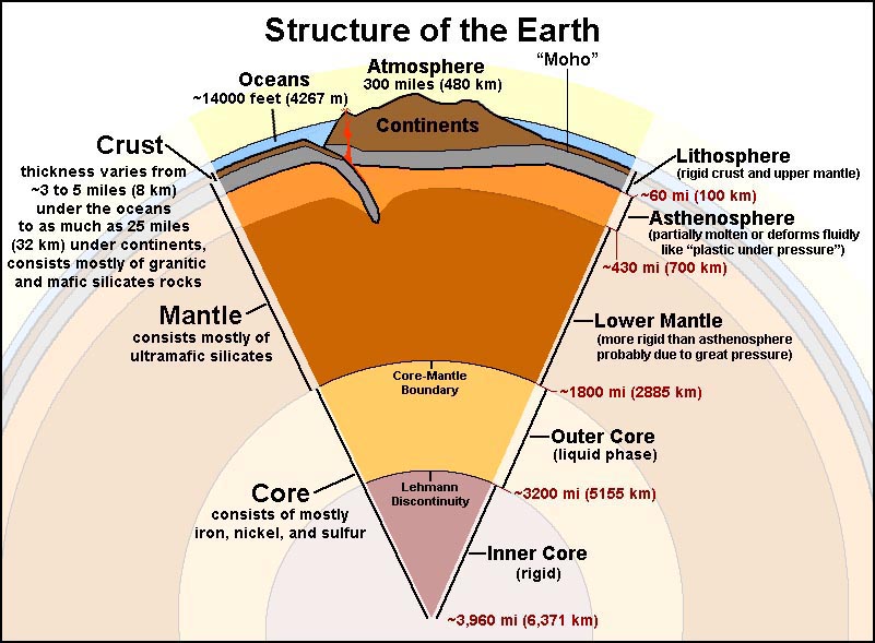 Fig. 3-8. Structure of the Earth  Fig. 3-9. An iron-nickel meteorite is magnetic and has a similar density as the metallic core of our planet. |
How do we know the structure of the Earth? By indirect geophysical methods! Geophysical methods use technical applications and equipment to collect information about the earth, oceans, and atmosphere that are not directly observable by our senses. Examples include:
The sections that follow explore the types of information we can learn from these three methods. |
 Fig. 3-10. Gravity can be precisely measured from orbiting satellites. |
Magnetism Measurements Reveal the Earth's Metallic CoreEarth's magnetic field is believed to be formed by the convection of hot, molten iron in the outer core. There must be significant amounts of iron for Earth to have such a strong magnetic field.The Geographic North Pole is the axis of Earth's rotation. It is is currently offset from the Magnetic North Pole by about 11.5 degrees (same with the South Poles). The magnetic poles are very slowly wandering relative to the geographic poles. This wondering of the magnetic poles is caused by gradual changes of Earth's magnetic field. Current thought is that shifts in Earth's magnetic field are probably caused by changes in gravity-driven flowing currents in the planet's liquid-metallic outer core. Magnetic Reversals: The Earth’s magnetic field reverses, causing the locations of the north and south magnetic poles to switch. If a magnetic reversal were to occur today, then a magnetic compass would point to the South Magnetic Pole instead of the North Magnetic Pole. Geologists and geophysicists have determined that magnetic reversals have happened many times through geologic time. Magnetic reversals are preserved in the “paleomagnetic record” - preserved as weak magnetic fields locked into rocks bearing magnetic minerals at the time they form (see the Paleomagnetism discussion below). We think that the magnetic reversals are probably caused by shifting currents in Earth's liquid metallic outer core. When a magnetic reversal occurs, basically what happens is the north magnetic pole becomes the south magnetic pole, and vice-versa. This switching of magnetic poles can last for periods ranging from thousands millions of years. Hundreds of magnetic reversals are recorded in the geologic records, observed in rocks on continents and the seafloor in many regions around the globe where rocks of all ages are preserved. |
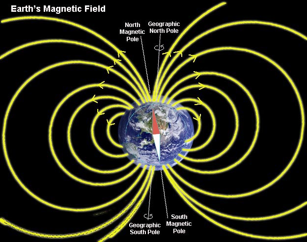 Fig. 3-11. Earth's magnetic field (the magnetosphere) extends from the core and far out into space. |
Gravity MeasurementsGravitometers are devices that measure very tiny differences in Earth's gravitational field from one place to another. Gravity measurements are also calculated measuring subtle changes in the paths of Earth orbiting satellites. Orbiting satellites are pulled closer to Earth over regions of higher gravity.Gravity measurements reveal that there must be denser material deeper in the Earth. Rocks at the surface of the planet are not dense enough to account for the overall higher amount of gravitational attraction that exists between objects on the surface and objects orbiting the planet. Variations in gravitational forces also reveal subtle differences in the density and thickness of the crust in different regions of the world. Figure 3-12 shows variations in the Earth's gravitational field as revealed by satellite gravity measurements. The map shows that older and colder crust, such as under regions in the oceans, is denser (having higher gravitational attraction) than where new ocean crust is forming along mid-ocean ridges. Gravitation is less where the crust is less dense, such as beneath continental regions and where rocks are hotter (associated with regional volcanism). Gravitational forces increase with increasing mass and decreases with distance. The greater the mass between to objects (such as moons or satellites orbiting planets), the greater the gravitational attraction. In addition, the closer two objects (such as moons and planets), the greater the gravitational attraction. |
 Fig. 3-12. NASA's gravity anomaly map shows subtle differences in the Earth's gravitational field in different portions of the world. |
Earthquakes, Faults, and Earthquake FaultsAn earthquake is ground shaking caused by a sudden movement on a fault, by a volcanic disturbance, a landslide, or a explosion (natural or man made).A fault is a fracture or crack along which two blocks of rock slide past one another. This movement may occur rapidly, in the form of an earthquake, or slowly, in the form of creep. Earthquakes occur somewhere around the world every hour of every day. Most are too small to even feel. However, large-magnitude, damaging earthquakes happen somewhere around the world almost every year. Large earthquakes can cause widespread chaos, destruction, and death. Earthquakes are associated with faults, but not all faults currently generate earthquakes (some faults may have been active long ago, but are now inactive). Faults range is size from small fractures in a local outcrop to great fault systems that can extend for thousands of miles. |
Features Associated With FaultsA fault is a fracture or crack along which two blocks of rock slide past one another. This movement may occur rapidly, in the form of an earthquake, or slowly, in the form of creep (Figure 6-18). Types of faults include strike-slip faults, normal faults, reverse faults, thrust faults, and oblique-slip faults. Faults can be small to large complex systems of interlinking faults and may change form one kind of fault in one location to another kind somewhere else. Many faults are associated with folds. Faults split, bifurcate, merge, or can peter out over distances, sometime forming complex systems of fractures.The relative motion of faults (one side to the other) is described in terms of relationship of a hanging wall and foot wall (see normal fault and reverse fault examples in Figure 3-13). A foot wall is the underlying block of a fault having an inclined fault plane. A hanging wall is the block (rocks) on the upper side of an inclined fault plane. Simply described here—if a fault is exposed well enough to see that the fault plane is inclined, the side you could stand on is called the foot wall. The side you could hang from without your feet touching the ground is the hanging wall. For instance, on a normal fault, the hanging wall has moved down relative to the foot wall. On a reverse fault, the hanging wall has moved up relative to the foot wall. |
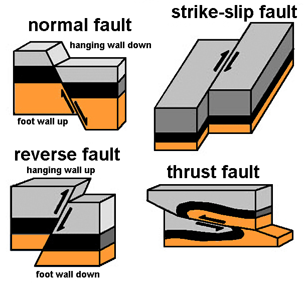 Fig. 3-13. Block diagrams illustrating common types of faults: normal fault, reverse fault, strike-slip fault, and thrust fault. Offset strata illustrates the relative motion of the foot wall to the hanging wall of each type of fault. Fig. 3-13. Block diagrams illustrating common types of faults: normal fault, reverse fault, strike-slip fault, and thrust fault. Offset strata illustrates the relative motion of the foot wall to the hanging wall of each type of fault. |
Terms Used To Describe EarthquakesA rupture zone is the area of the Earth through which fault movement occurred during an earthquake. For large earthquakes, the section of the fault that ruptured may be several hundred miles in length. Ruptures may or may not extend to the ground surface.A focus is the point below the Earth's surface where seismic waves originate during an earthquake (Figure 3-14). An epicenter is the point on the Earth’s surface above the point at depth in the Earth’s crust where an earthquake begins. |
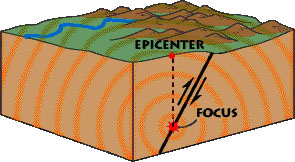 Fig. 3-14. Diagram illustrating the focus and epicenter of an earthquake along a fault. |
Seismic WavesSeismology is the study of earthquake shock waves as they pass through the earth. Seismology is the science that helped resolve many questions about the internal structure of the earth.Seismic waves are shock wave and vibrations in the Earth which issue from the focus of an earthquake. Seismic waves are a result of an earthquake, impact, or explosion, or some other process that imparts low-frequency acoustic energy into the earth. (Figures 3-14 and 3-15). Two Types of Seismic Waves: Surface Waves and Body Waves• Surface waves travel on the surface.• Body waves travel through the earth. There are two types of body waves: P waves and S waves P (primary) waves are compressional and cause rocks to move back-and-forth parallel to the direction of wave movement. • P waves travel faster than S waves through denser and more compact elastic materials (solid, liquids, gases). S (shear) waves have a shear effect and cause rocks to move back-and-forth perpendicular to the direction of wave movement. • S waves are slower than P waves and travel only through solid mater, not liquids or gases. S wave speed varies depending on materials, but typically they only move about 60-70% as fast as P waves in the upper part of the Earth's crust. The fact that S waves travel through all parts of the Earth except the outer core tell us that the outer core is the only part of the Earth's interior that is fully liquid. |
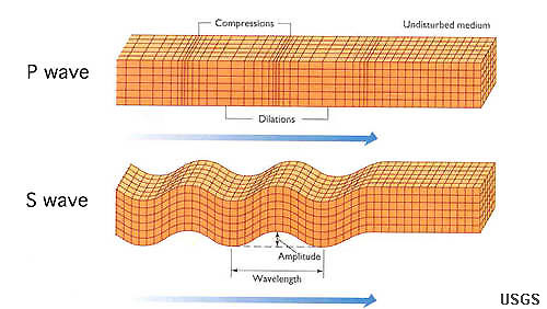 Fig. 3-15. Earthquake waves include: P-compression waves and S-shear waves. P-waves move faster than S-waves and are first to be felt. The S-waves arrive next and produce the majority of shaking in an earthquake. |
Locating Earthquakes With SeismographsA seismograph is a device used to record earthquake shaking and is used to determine the distance from an earthquake focus, and the magnitude and intensity of earthquakes. Data from numerous seismographs linked together in networks are used to determine the focus, epicenter, extent of rupture, and amount of shaking in a region caused by an earthquake. A minimum of 3 seismographs are needed to determine the epicenter of an earthquake (Figure 3-15).Note that the Global Seismographic Network consists of thousands of seismographs around the world, so information about earthquakes can be calculated quite precisely. In earthquake-prone regions, many seismographs have been installed, along with related fault motion sensors that measure stress and strain buildup along faults or the extremely slow creep of some faults, and even changes in the gas content, water level changes, and electrical properties of rocks in the vicinity of fault zones. The more measurement devices, the better detail can be determined about the nature of earthquake-prone fault systems. |
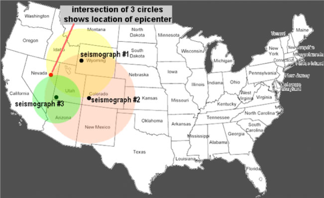 Fig. 3-15. At least three seismographs are needed to locate the epicenter of an earthquake. A single seismograph can only tell you how far away an earthquake occurred, but not in which direction. |
Describing Earthquakes: Earthquake Magnitude and Earthquake IntensityEarthquake magnitude (M) is a numeric measure that represents the size or strength of an earthquake, as determined from seismographic observations. The Richter scale is a numerical (logarithmic) scale for expressing the magnitude of an earthquake on the basis of seismograph oscillations. Today earthquake intensity is recorded with a Moment Magnitude Scale (MMS) which is based on the seismic moment of the earthquake, which is equal to the rigidity of the Earth multiplied by the average amount of slip on the fault and the size of the area that slipped. Richter scale and moment magnitude scales are similar, but the MMS scale is more precise (Figure 3-13).Earthquake intensity (I) is a measure of ground shaking describing the local severity of an earthquake in terms of its effects on the Earth’s surface and on humans and their structures. The Modified Mercalli Intensity (MMI) scale, which uses Roman numerals, is one way scientists measure intensity (Figure 3-16). Video: Earthquake Magnitude Power Comparison (See the frequency of size of historic earthquakes) Video: Earthquakes of the First 15 Years of the 21st Century (US NWS Pacific Tsunami Warning Center) |
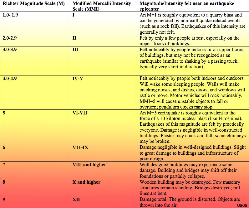 Fig. 3-16. Comparison of earthquake magnitude (MMS) and intensity (MMI) scales (USGS) |
How do seismic wave data reveal the internal structure of the Earth?Earthquake Shadow Zones: Extensive study of shock waves of earthquakes and the global monitoring of underground nuclear bomb testing reveal information about the internal structure of the Earth. P and S waves both go through solids. S waves do not go through non-solids, so only P waves are received on the opposite side of the Earth. Zones of seismic wave shadows occur in the regions shown in Figure 1-17 between about 105° to 140° on the opposite side of the globe from a seismic shock. These shadow zones shows us that part of the Earth's core is liquid material (molten material). In contrast, the inner core is believed to consist of solid metal, possibly similar in composition of iron meteorites.What can seismic (P and S) waves data tell us? • Parts of the earth are not solid. • The depth and location of an earthquake. • The relative strength of an earthquake. • The average density of Earth. • The density of each layer in the Earth. |
 Fig. 3-17. Seismic shock wave provide information about the structure of the Earth. |
Earth’s Major Boundaries Revealed By Seismic WavesThe Moho (Mohorovicic discontinuity): (Discovered in 1909 by Andriaja Mohorovicic)• The Moho is the boundary between the crust and the mantle. It separates less dense crustal rock from underlying denser mantle rock. • Identified by a change in the velocity of P waves The core-mantle boundary (CMB): (Discovered in 1914 by Beno Gutenberg) • Based on the P-wave shadow zone • No P waves from 105 to 140 degrees • The fact that S waves do not travel through the outer core provides evidence for the existence of a non-solid layer beneath the mantle • Showed existence of liquid outer core and overlying mantle Lehmann Discontinuity (Predicted by Inge Lehmann in 1936) • Boundary between outer and inner core defined by an increase in seismic wave velocity from outer to inner core and by seismic wave reflection off the solid inner core. The locations of the Moho, CMB, and Lehmann Discontinuity are shown in Figures 3-8 and 3-17. |
Seismic Wave Data Used To Map the LithosphereEarthquake data also reveals the location of major fault zones of the world (Figure 3-18). Many of the fault systems are associated with lithospheric plate boundaries (see discussion below).Fault systems evolve and change over time—driven by plate tectonic forces associated mantle convection influencing the rigid lithosphere. Fault systems are often associated with volcanic regions. Faults may form and remain active for long ages before becoming inactive, and then may become reactivated again in some later period. Tectonic forces within the Earth deform rocks through processes of folding and faulting, producing mountains, valleys, and may other landscape features. |
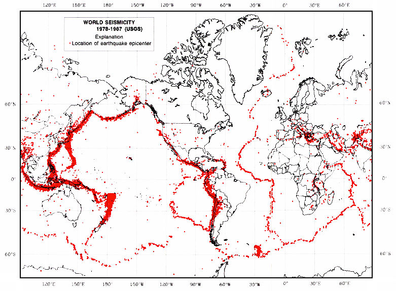 |
| Fig. 3-18. Map of earthquakes of the world (USGS record for 1978 to 1987). |
Mantle ConvectionGravitational heat convection in the mantle is the source of forces that move, bend, and break rocks in the Earth's lithosphere (Figure 3-19). Heat in the Earth is produced by radioactive decay of unstable isotopes as well as heat left over from when the Earth formed billions of years ago in the solar system's nebula.Motion within the mantle is responsible for deep crustal stretching (extension) and compression. Motion in the mantle is produced by gravitational heat convection—hot rocks expand and rise whereas cooler (hence denser) rocks sink. Thicker, less dense, continental crust floats higher than thinner, denser ocean crust below ocean basins. Gravity-driven heat convection within the Earth is the conclusive power source driving plate tectonic motions. |
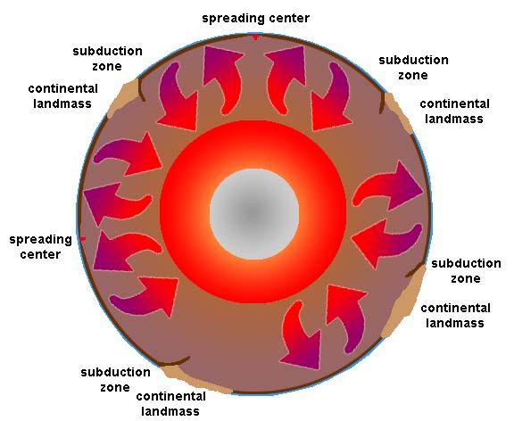 Fig. 3-19. Mantle convection is the driving force of movement in the Earth's lithosphere. |

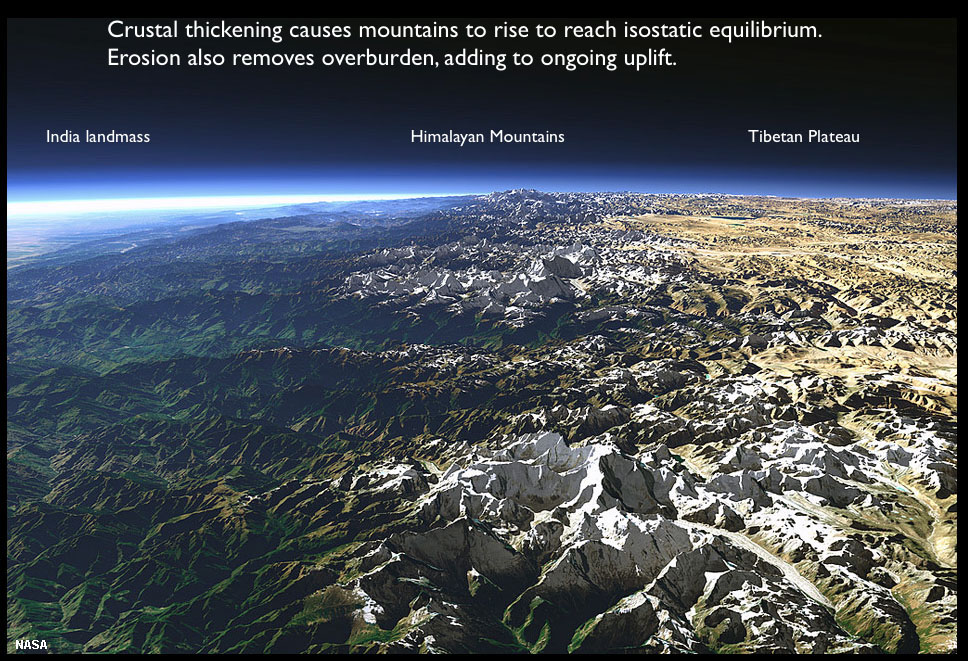
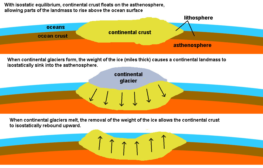
Isostasy and the Age and Evolution of Continental LandmassesMany hypotheses were put forward to try to explain the evolution of landscapes—isostasy was one of them. Early hypotheses focused on what was easily observable. Continents around the world shared a variety of large physiographic features: mountain ranges, coastal plains, plateau regions, and inland lowlands. Some of these lowland regions are underlain by what appeared to be ancient rocks that were once to core of mountain ranges in the distant past. These regions were located near the center of most of the continents and have became known as shields (such as the Canadian Shield of North America, see Figure 3-24). In most cases, these shields are surrounded by belts of mountain ranges that were composed of rocks that appeared younger than the shield regions. Also, some of these mountain ranges appeared much younger than other mountain ranges. This lead to conclusions that landscapes could be classified as youthful, mature, or old age —assuming that all mountain ranges form about the same way, and that youthful mountain ranges, like the Himalayan or Rocky Mountains eventual erode way (becoming more mature with age, like the Appalachian Mountains). Eventually almost all elevated features (mountains, hills) completely erode away, producing "old age" landscapes, similar to what is seen in shield regions (see Figure 3-24). The erosion of material from continental region contribute mass to the submerged regions along continental margins. In many regions along the continental margins the weight of additional sediments are casing them to sink (such as near the mouth of rivers, such as the Gulf Coast near the Mississippi River delta).The assumption is that as materials erode away, the crust readjusts itself to maintain an isostatic equilibrium. As material is removed the crust rises. Over time, material that were once deep within mountain ranges eventually becomes exposed at the surface by erosion. Over time, the assumption was that isostatic adjustments eventually cease, and the mountains would completely erode away to a flat plain and eventually sink below the waves. Unfortunately, there were too many cases where the isostatic adjustment hypotheses didn't match all the observable facts. Not all old shield regions were low plains (as illustrated with the Scandinavian region of Europe and much of Africa). In addition, some regions, such as the Colorado Plateau, had characteristics that fit into all three categories, youthful, mature, and old age, all at the same time. In addition, there was very little to explain how mountain ranges and continents formed in the first place! Why do some mountain ranges have volcanoes and other don't? What would explain the composition and distribution of volcanic mountain ranges around the world, and what in the world could explain what chains of volcanoes like the Hawaiian archipelago were doing in the middle of the Pacific Ocean? These questions (and more) were finally resolved with the development of Plate Tectonic Theory. |
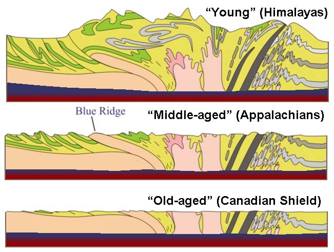 Fig. 3-24. Isostasy and the hypothesis of landscapes evolving through youthful, mature, and old age stages. Evolution of a landscape over time involves uplift, erosion, and isostasy. |
Plate Tectonics Theory |
|
| Plate Tectonics is a unifying collection of concepts that explains most things geological on Earth, and other planets and moons as well. (Note: Plate Tectonics is the focus of Chapter 4). Plate Tectonics theory explains the structure of the Earth's crust and many associated phenomena as resulting from the interaction of rigid lithospheric plates that move slowly over the underlying mantle. Plate Tectonics (definition) (Illustrated in Figure 3-25.) • A theory that states that the earth's solid outer shell (lithosphere) broken into large, rigid pieces called plates that can move relative to each other by sliding atop the non-solid asthenosphere. • Plates are thought to move due to a combination of convection in the asthenosphere and gravity. These forces are discussed in more detail in Chapter 4. • Most volcanoes and earthquakes occurs where the solid lithospheric plates meet. |
Fig. 3-25. General model representing essential concepts presented by Plate Tectonics Theory (discussed in Chapter 4). |
| Deformation is the action or process of changing in shape or distorting, especially through the application of pressure. In geologic terms, deformation refers to changes in the Earth's crust related to tectonic activity, particularly folding and faulting. Heat from inside the earth drives mantle convection (hot material rises, cool material sinks, Figure 3-19). The rise and fall of masses of material in the mantle create forces that move the rocks in the cool and brittle lithosphere near the Earth's surface. These motions exert great forces, strong enough to rip continents apart, but the rate of movement is extremely slow on an annual basis (measurable in inches or centimeters per year). Whereas the fluid-like state of rocks in the asthenosphere move slowly, the solid, brittle material in the lithosphere builds up great pressure (stresses) and the rocks will strain under the pressure until the point that they rupture, causing earthquakes that propagates as a shock waves through the Earth. |
Historical Observations leading up to Plate Tectonics Theory |
|||||||||||
|
Much of the background work related to the modern theory is the culmination of hundreds of years of world-wide exploration and geologic observations that go back several centuries. Highlights include: * Early Maps of the World: Maps compiled by early global explorations resulted in the observation of the matching shapes of the coastlines on opposite sides of the Atlantic Ocean. These similarities were noted from early maps by by a Flemish cartographer named Abraham Ortelius in 1596 who first suggested that it looked like the continents had drifted apart. Geographers preparing maps noted that charts of land masses that the shape continents of the world fit together like a jig-saw puzzle. It took centuries before an organized effort started to analyze the data! * Observations of the location of the world's volcanoes (maps) and lead to the recognition of the Ring of Fire (Figure 3-26). As we will see in the next chapter, the volcanoes of the Ring of Fire relate directly to Plate Tectonics Theory. Continental DriftThe Continental Drift Hypothesis was a prelude to the modern Plate Tectonics Theory.The Continental Drift Hypothesis was proposed by a German astronomer and meteorologist named Alfred Wegener (1880-1930), but based on research by other earlier observers. The Continental Drift Hypothesis was based on observations that the continental coastlines on either side of the Atlantic Ocean seemed to match up. More importantly, the drift hypothesis was supported by similarities of fossils, rocks, and mountain belts on both sides of the Atlantic, as explained further below. Wegener's hypothesis was that all the observable continents bordering the Atlantic and Indian Oceans had once assembled into a single supercontinent that he named Pangaea. He determined that this great landmass began to break apart about 200 million years ago (Figures 3-27 to 3-29). He said that these continents started moving about 200 million years ago (MYA) and they are still moving. This is amazing because Wegener proposed this more than 100 years ago and it remains correct today. However, the theory was rejected by most scientists at the time.
Geologic and fossil evidence indicated that some land masses which are now separated may have been together at some point in time. However, nobody could provide a mechanism for the continents to move.
|
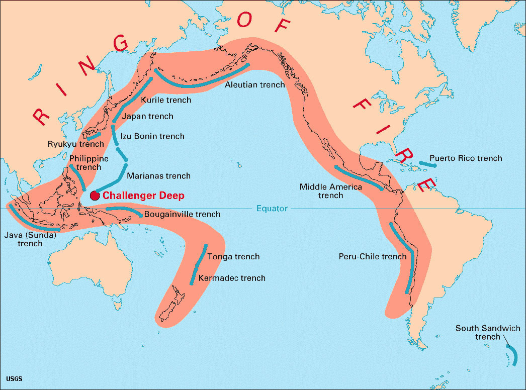 Fig. 3-26. The Ring of Fire is a zone of volcanoes, numerous earthquakes, and offshore deep trenches. 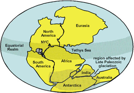 Fig. 3-27. Geographers noted that the continents fit together like a jig-saw puzzle. 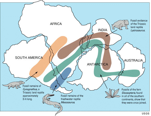 Fig. 3-28. Fossil evidence connecting lands of Pangaea about 260 million years ago)  Fig. 3-29. The formation and breakup of Pangaea over 300 million years. |
||||||||||
The Atlantic-Pacific ParadoxEarly exploration of Atlantic Ocean basin showed that it is surrounded mostly by gentle coastal planes and old, worn down mountain ranges, and had relatively little volcanic or earthquake activity in other regions. In contrast, the Pacific and other ocean regions were much less understood. In contrast, early exploration of the Pacific Ocean basin brought awareness of the region described as the Ring of Fire (see Figure 3-26). In most places around the Pacific Rim's Ring of Fire the transition zones of the continents to the deep ocean has large numbers of active or recently active volcanoes. This region also experiences large numbers of tremendous earthquakes. In most places where volcanic arcs (island belts and mountain ranges composed of volcanoes) appear on land, there are also very deep-water trenches located not too far offshore of the coastline.Why was Continental Drift rejected by the Scientific Community?Although Continental Drift intrigued the scientific community, it was largely rejected because there was no data to explain all the observable facts about how or why continents moved across ocean basin. This was largely because in the early 20th century very little was known about the nature of the world's ocean basins nor the physical characteristics of the structure of the Earth's asthenosphere and lithosphere. Many other hypotheses existed in the scientific community well into the late 20th century, but these conflicting ideas have faded in significance with the advances of the newer Plate Tectonics Theory. Wegener's hypothesis was rejected because he proposed a mechanism for continental drift, which turned out to be wrong.• His mechanism was complicated and involved the force of the earth spinning and the tides. • He was dismissed as a crank and his detractors said that he carefully picked his data to fit his hypothesis. • At this point in time the entire Earth was solid, so it was difficult to formulate a mechanism for continental drift. |
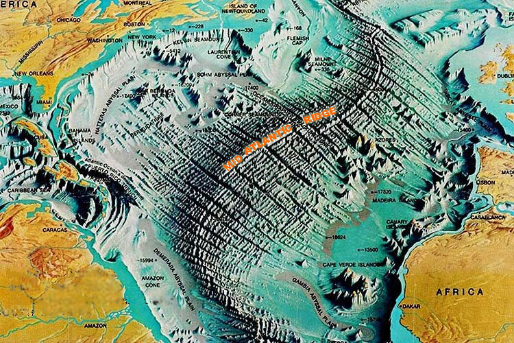

Paleomagnetism and the Study of the SeafloorEarth's magnetic field has been a curiosity since ancient times. The magnetic compass was first invented as early as the Chinese Han Dynasty (about 206 BC). The compass was used during China’s Song Dynasty for military navigation by 1044 AD, and for maritime navigation by about 1117 AD. Today, the source of the magnetic field is presumed to be from the movement of molten iron and metals in the earth's core. The spinning of these liquid metals produces electric currents in the same manner as an electric coil produces a magnetic field. The magnetic field extends into space (see Figure 3-11). Over time, these currents fade, change direction, or intensify elsewhere, causing the magnetic poles to migrate or reverse the magnetic polarity of the entire planet (events called magnetic reversals).Magnetometers (devices used to detect and measure the strength of magnetic fields) were used in World War II to search for submarines. It was noted from these investigations that the seafloor preserved large magnetic anomalies that lined up parallel the Mid-Atlantic Ridge (Figure 3-32). These investigations showed that the Earth's magnetic field has reversed many times through Earth history; magnetic reversals happened over periods ranging from thousands to millions of years. The chronology of magnetic reversals through geologic time are now well know. Paleomagnetism is the study of the fixed orientation of a rock's magnetic minerals as originally aligned at the time of the rock's formation (simply, old magnetism). Paleomagnetism is usually the result of thermoremanent magnetization (magnetization that occurs in igneous rocks as they cool below a certain temperature (called the Curie Point). As rocks (with iron in them) solidify, the magnetism direction points to the magnetic pole (which is currently north).Igneous rocks may keep their magnetic orientation they obtain at the time they form (if they are not altered). This magnetic signature is preserved, even if the landmass the magnetic rocks are on is moving. Mapping of the seafloor with magnetometers revealed lines of rock preserving history of magnetic reversals running parallel to the mid-ocean ridges [first published by Vine & Matthews, 1963] (Figure 3-33). With decades of studies of paleomagnetism of seafloor rocks and volcanoes around world the chronology of magnetic reversals through geologic time are now well known. Paleomagnetism studies provide important data for resolving the age of rocks, where they formed, and where they have traveled over time. Fundamental information about the formation of new oceanic crust and explains the migration of landmasses over time. Paleomagnetism studies are fundamental to the theory of seafloor spreading. Seafloor SpreadingSeafloor spreading is the processes associated with the formation of new areas of oceanic crust, which occurs through the upwelling of magma at mid-ocean ridges and its subsequent outward spreading movement on either side. As new rock forms along spreading centers it becomes attached to the lithospheric plates on either side of the spreading centers. Because the Earth's magnetic field is reversing frequently through geologic time, the rocks forming and moving away from spreading centers preserve the pattern of preserved magnetic orientation. This pattern turns out to be mappable (Figures 3-32 and 3-33).Paleomagnetic studies of the world ocean basin resulted in the discovery of mid-ocean ridges and spreading centers. These undersea mountain ridges extend for 10s of thousands of miles beneath portions of the global ocean basins (see Figure 3-18, 3-30, and 3-36 below). Seafloor spreading became a mechanism to explain continental drift. However, seafloor spreading alone does not explain the formation of continental landmasses through geologic time. |
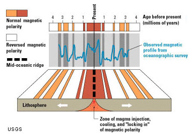 Fig. 3-32. Mapping of the seafloor with magnetometers revealed lines of magnetic reversals on opposite sides of mid-ocean ridges. (USGS) 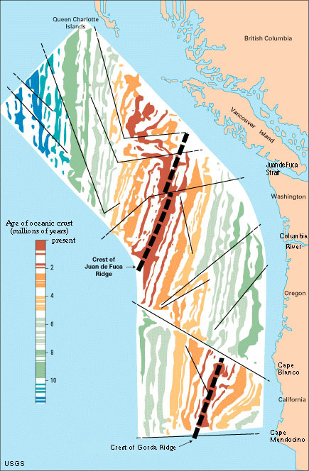 Fig. 3-33. West Coast magnetic reversals reveal the location of spreading centers and fault boundaries in the ocean basin offshore of California, Oregon, Washington, and British Columbia |
Another Geologic Paradox: the rocks of the ocean floors are much younger than the rocks of the continents |
|
In the late 1940's methods of radiometric-age dating were developed. After WW2, samples of ocean crust and sediments were collected from the sea floor throughout the world ocean basins and analyzed using both radiometric-age dating (decay of radioactive isotopes) and relative dating (using microfossils derived from seafloor sediment coring samples). Geologic data indicated a relatively young sea floor (ocean crust), where the oldest is about 200 million years old. However, data also indicated very old continents, where the oldest was more than 3 billion years old!
What was discovered was that, in general, most of the oldest rocks found in the Earth's crust occur in the center of continental landmasses, such as in the Canadian Shield region of North America, Greenland, the central parts of Africa, South America, Australia, and Siberia, and the peninsula of India (Figure 3-34).Thee regions have rocks that range in age to typical over a billion years to the oldest know rocks of about 4.4 billion years (from Australia). These regions are called continental shields. Note that it is within these regions that most of the world's most economically significant gem and precious metal deposits are found! Surrounding the continental shields on most of the continents are belts of mountain ranges and coastal plains that contain rocks younger that a billion years in age. The higher mountain ranges, including the Himalayan, Andes, Alps, and Rocky Mountains are considered to be actively forming and are dominated by rocks that have formed after the breakup of the supercontinent Pangaea (mostly after about 300 million years ago). There are some older mountain ranges, like the Appalachian Mountains in eastern North America, that appear more worn down, and the areas are relatively inactive geologically (having fewer earthquakes and little recent volcanic activity). By comparison, the landscapes within the shield regions are nearly completely worn down and are no longer geologically active. However, these shield regions display characteristics of having once been parts of mountain ranges that existed a billion or more years ago. In many areas parts of the shield regions, ancient mountain ranges have formed, eroded away, and reformed again and again, but today, in contrast, there is very little geologic activity (volcanoes or earthquakes). Figure 3-35 is a map showing the age of rocks found in the crust beneath the ocean basins of the world. Again, beginning in earnest during World War II and culminating in the Cold War, geophysical mapping and sampling of materials from the sea floors around the globe showed that rocks on the ocean basins were very significantly younger that rocks found on the continents, with ages ranging in only about 200 million for the oldest rocks beneath ocean basins! In all cases, the age of seafloor grows progressively younger approaching the mid-ocean ridges. Using seismic data and deep-sea submersible exploration craft, the mid-ocean ridges were discovered to be belts of undersea volcanic areas. New ocean crust was (and is) forming along the mid-ocean ridges (Figure 3-36). In contrast, old ocean crust is sinking back into the mantle or being added onto some continental margins (discussed in Chapter 4). |
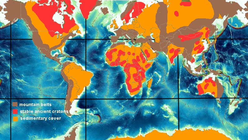 Fig. 3-34. Map of the world showing continental mountain belts (brown) and stable ancient cratons or shield regions (orange and red, the oldest rocks being red). Ocean bathymetry (in shades of blue) show mountain ranges (mid-ocean ridges) beneath the oceans. 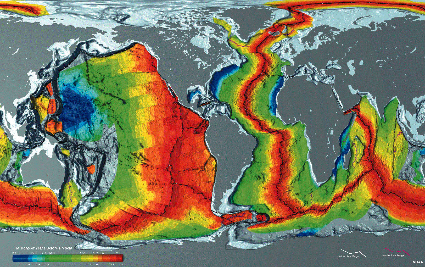 Fig. 3-35. Geologic and geophysical mapping show that the crustal rocks beneath the modern oceans are less that 200 million years, with the youngest rocks (and some actively forming) occur along mid-ocean ridges. 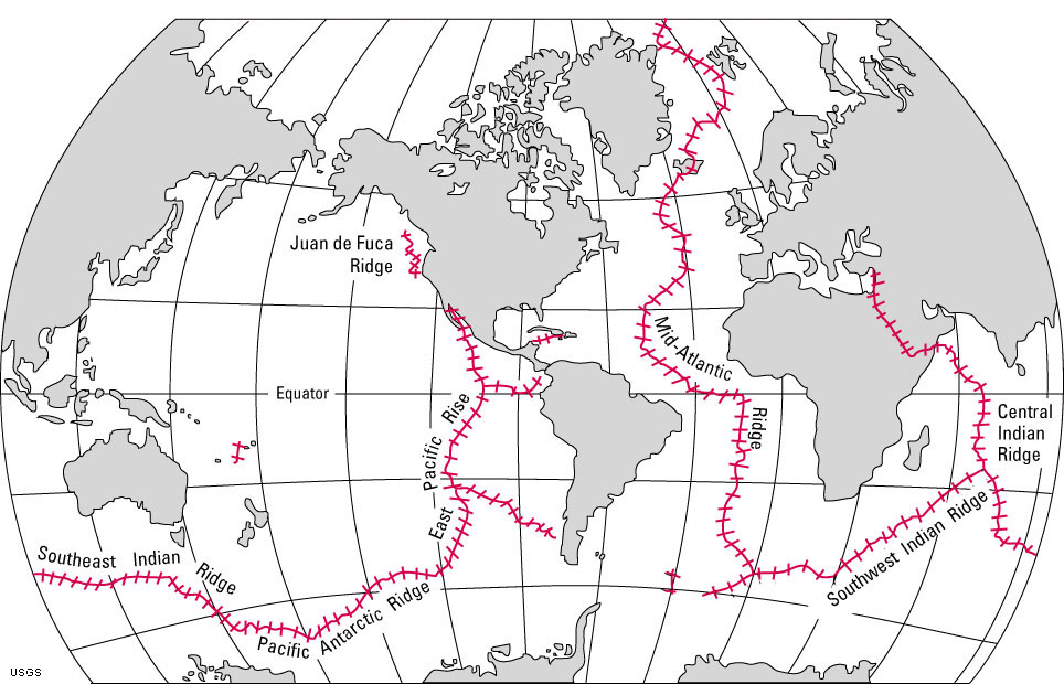 Fig. 3-36. Map showing the location of the world's mid-ocean ridges. These undersea mountain ranges are the longest on earth. Mid-ocean ridges (where new ocean crust is forming) is found beneath portions of all the world's ocean basins. |
| Chapter 3 Quiz Questions |