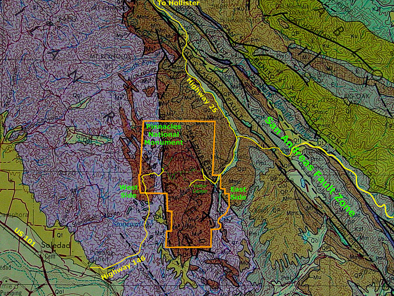
The Pinnacles (named for the high spire-shaped rock formations) owe their origin to weathering and erosional processes associated with prevailing climatic conditions over time. The region has warm, dry summers, and mild, wet winters (a Mediterranean climate). The Pinnacles are within the larger Gabilan Range, an uplifted belt of rock along the west side of the San Andreas Rift Zone (a valley associated with the fault system). Rocks in the Diablo Range consist mostly of Cretaceous and older granite with a cover of younger Tertiary-age marine and non-marine sedimentary formations, and volcanic rocks (such as the Pinnacles area). The Gabilan Range is still gradually rising relative to the Salinas Valley to the west. In the geologic past, relatively soon after Pinnacles volcano had formed, the volcanic rocks were likely buried in a graben or basin-like setting, otherwise the volcanic rocks of the pinnacles would have likely eroded away long ago. Today, the Coast Ranges are slowly rising as the regional fault system and crustal structure continues to evolve. To the east, the Diablo Range has a core of ancient oceanic crustal rocks (mostly serpentinite and associated rocks) with a blanket of younger Cretaceous and Tertiary sedimentary rock formations. An erosional valley drained by the San Benito River roughly follows the trace San Andreas Fault system between the Pinnacles and Gabilan Range (to the west) and the Diablo Range (to the east).
The map used as a base for the above image is part of the map: California Department of Natural Resource, Division of Mines, 1959, Geologic Map of California, Santa Cruz Sheet, 1:250,000.
Selected abbreviations for named map units include:
Qal - Quaternary alluvium |
Mu - Upper Miocene marine |