61. Verrazano Narrows
Although the land was occupied by Algonquin Indians, the Narrows between what was to become Brooklyn and Staten Island was first known to be seen in 1524 by Giovanni da Verrazano, an Italian explorer sailing for the French. Henry Hudson named Staaten Eylandt (Is-stat-un-island?) 85 years later. The Narrows are the passage between constricted lands separating the Inner and Outer New York Harbor between the hills of Bay Ridge in Brooklyn (western Long Island) and eastern Staten Island (Figure 154). At the western end of Long Island, the older Ronkonkoma moraine and younger Harbor Hill moraine coalesce. These moraines form Bay Ridge, the long low hill along the eastern side of the Narrows in Brooklyn. Third Avenue, the street that held the Guinness world record for having the most bars, stretches for 40 city blocks along the top of this ridge. The combined Ronkonkoma and Harbor Hill moraines also form the hillsides on the Staten Island side of the Narrows. These moraines piled up around the sides of Todt Hill (elevation 409 feet). During the maximum southward advance of the Wisconsin glacier Todt Hill must have stood out as a small barren, rocky knob at the base of the enormous ice sheet to the north.
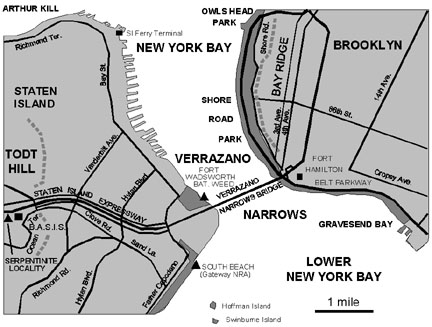 |
| Figure 154. Map of the Verrazano Narrows area (Brooklyn and Staten Island). |
As the glacier melted, a series of great lakes developed behind the natural
dams of the Harbor Hill moraine. This morainal dam was breached in the
vicinity of the Verrazano Narrows, and the draining rivers carved a chasm
through the till that extended downward to bedrock. To this day, the daily
in-and-out flow of the tides through the Narrows maintains a water depth
of 100 feet, the deepest water along the length of the Hudson River drainage
and in the Inner New York Bight
In 1776, the British prepared for the invasion of Long Island by massing
troops and Hessian mercenaries on Staten Island. The Revolutionary War
began with invasion of Long Island by troops crossing the Verrazano Narrows
on barges constructed on Staten Island. After the War of 1812, two forts
were built on either side of the Narrows to protect the entrance of Inner
New York Harbor: Fort Hamilton on the Brooklyn side, and Fort Wadsworth
on the Staten Island side. Battery Weed, a large granite fortress, was
built prior to the Civil War with in a commanding position on the Staten
Island shore overlooking the Harbor (Figure 155). The fort is now part
of Gateway National Recreation Area. A park overlook above the fort provides
one of the most spectacular views of the harbor region, including Downtown
Manhattan and the Verrazano Bridge. Construction of the Verrazano Narrow
Bridge began in 1959; it was opened in November, 1964. The span of the
bridge is 4,260 feet (1,298 m) and has a maximum clearance of 228 feet
above mean high tide sea level at midpoint. The two towers rise 693 feet.
It remained the longest suspension bridge in the world until completion
of the Humber Bridge in Great Britain in 1981. The completion of the Verrazano
Narrows Bridge led to the rapid urban development of Staten Island.
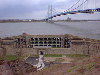 |
| Figure 155. Battery Weed in Fort Wadsworth overlooking the Verrazano Narrows Bridge and bay from Staten Island. |
On the Brooklyn Side of the Verrazano Narrow is Shore Road Park. It extends from Owl's Head Park and a pier at 69th Street southward along the Belt Parkway to John Paula Jones Park at 101st Street, adjacent to the Verrazano Bridge. Owl's Head Park still partially preserves the rolling topography of the Harbor Hill moraine. Along the edge of the bay is a foot and bicycle path connected to Shore Road Park by several bridges over the parkway. The shore path park continues southward for an additional two miles to a shopping area at Gravesend Bay. Along the Belt Parkway there are several parking areas that provide access to the park. Additional parking is possible throughout Bay Ridge along Shore Road at Exit 2 (4th Avenue/Fort Hamilton) off the Belt Parkway. An easy alternative to driving (which is always the case in Brooklyn) is to take the R Train to the end of the line at 95th Street, and walk six blocks southwest along 4th Avenue to the park.
The shore path is an extremely popular recreational site for the borough of Brooklyn. The sweeping views of the Narrows, the moraine and Todt Hill on Staten Island, and the Inner and Outer New York Harbors are spectacular. On a clear day the Atlantic Highlands are quite visible along the south side of Raritan Bay. Also of geologic interest is the rip-rap used to build the sea walls along the shore path. These massive rocks were derived from the construction of subway tunnels under the city. Some of the rock came from the excavations for the World Trade Center. In the area south of the bridge the rip-rap along the foot path consists of regional rocks including schist, granite gneiss, quartzite, marble, limestone, basalt, and diabase.
The Staten Island side of the Narrows is not as accessible. Private residences and piers line much of the shoreline. The exception is in the vicinity of the Verrazano Narrow Bridge where the National Park Service was recently given the majority of the historical military sites on Fort Wadsworth. As mentioned above, the view from the overlook above Battery Weed, adjacent to the bridge, is perhaps one of the most spectacular views of the city. Battery Weed was built on fill along the shore, whereas the older Fort Wadsworth was built with a commanding view on the morainal hilltop above Battery Weed. Beginning on the south side of the bridge is South Beach, another developed beach incorporated into the holdings of Gateway National Recreation Area. To get there, take the Hylan Blvd. Exit from the Staten Island Expressway and go north to Bay Street, then head south to Fort Wadsworth and the NPS Visitors Center. Although it will take longer, it is also possible to use public transportation, which requires either taking the R Train then a bus from 95th Street, or by taking the Staten Island Ferry from Manhattan, and then a bus.
| Return to Glaciers of the Quaternary page. |