Regional Geology of North America |
|
Atlantic and Gulf Coastal Plains |
Click on images for a
larger view. |
All continents have coastal plains created by erosion associated with the rise and fall level through geologic time. Coastal plains are the exposed equivalent of continental shelves. When continental glaciers form, sea level falls as precipitation is trapped on land as ice, causing sea level to fall, exposing the continental shelves. As continental glaciers melt, sea level rises (as is currently happening since the end of the last ice age, about 11,000 years ago). During the peak of the last ice age sea level was as much as 120 meters (400 feet) lower than it currently stands and the coastal plains extended seaward to the shelf break at the edge of the continental margins.
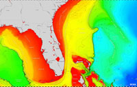
In addition, coastal plains (and continental shelves) are associated with thick blanket of sediments that have accumulated along the margin of continents. These wedges of sediments grow increasing thicker seaward and are formed from sediments eroded from land or accumulated as massive organic reef deposits formed in warm, shallow marine environments. For instance, the Florida Platform is underlain mostly by limestone and carbonate-rich sediments deposited in shallow marine environments when sea level was higher than today (Figure 14).
The Atlantic Coastal Plain and Gulf Coastal Plain are extensive because they are on the passive margin of the North American Continent (Figure 15). The sediments of the coastal plains have been accumulating since North America split away from the supercontinent Pangaea, starting about 200 million years ago. As the Atlantic Ocean basin opened, large quantities of sediments were shed from the eroding remnants of the ancestral Appalachian Mountains (discussed below), slowly building a thick wedge of sediments along the continental margin as the Atlantic Ocean Basin slowly expanded.
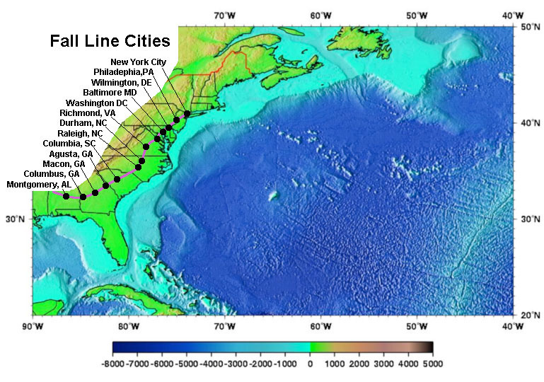
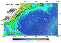
The western edge of the Atlantic Coastal Plain is marked by the "Fall Line" (Figure 16). The fall line is an imaginary line that basically marks the boundary where rivers draining from the Appalachian uplands descend onto the coastal plain become deep enough to be navigable by ocean-going ships. Most of the major cities in the eastern United States developed at the points where ships traveling up river valleys could stop to load/unload their goods. The fall line basically follows the ancient coastline when the Earth was last completely ice free (about 33 million years ago), before glacial ice began to accumulate in Antarctica, Greenland, and other glacial regions of the world. Since then sea level has risen and fallen many times, flooding and then re-exposing the coastal plain region many times.
The Mississippi Embayment is an extension of the Gulf Coastal Plain that extend northward into the greater Mississippi River Valley all the way to Cairo, Illinois (Figure 18). The coastal plain sediments of Late Cretaceous and younger ages lie unconformably on top of an eroded surface of more ancient bedrock of the Appalachian Mountains to the east and the Ouachita Mountains to the west. Along the border of the Mississippi Embayment, Cretaceous-age coastal marine sediments (called the Selma Formation) weather to produce the rich soils along a belt of land (including Selma, Alabama) that is famous for cotton farming and was a major economic region of the American South before the Civil War.
|
 |
 |
| Fig. 14. The Florida Peninsula is an exposed portion of a larger shallow shelf platform (shown in red—less than 200 meter deep). |
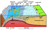
Fig. 15. Diagram of a continental margin showing the relationship of the coastal plain, continental shelf, and shelf margin. |
 |
 |
| Fig. 16. The "Fall Line" generally marks the western boundary of the Atlantic Coastal Plain. |
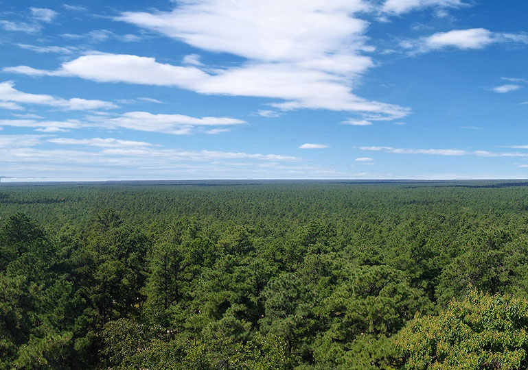
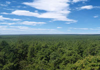
Fig. 17. The Pine Barrens of New Jersey is a region that illustrates a natural landscape on the Atlantic Coastal Plain. |
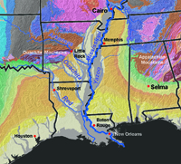 |
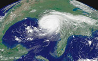
Fig. 19. Hurricanes play a major role in shaping the landscapes along the Gulf and Atlantic coastal plains. They redistributed sediments deposited by rivers and reshape the shorelines. This view shows Hurricane Katrina (2006) as it came onshore, causing the most costly natural disaster in US history in its time. |
| Fig. 18. Map showing the Mississippi Embayment, an extension of the Gulf Coastal Plain that extends northward into the Mississippi River Valley to Cairo, Illinois. |
Examples of National Parks located on the Atlantic and Gulf Coastal Plains (from north to southwest):
Fire Island National Seashore, Long Island, New York
Gateway National Recreation Area, New York and New Jersey
Assateagure Island National Seashore, Maryland
Cape Hatteras National Seashore, North Carolina
Biscayne National Park, Florida
Everglades National Park, Florida
Padre Island National Seashore, Texas
|
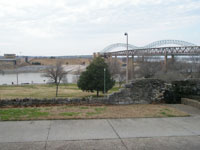 |
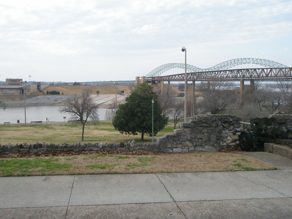
| Fig. 20. Bridge over the Mississippi River in Memphis, Tennessee, part of the Mississippi Embayment. |
|