
Glossary of Cloud Terms and Classification |
Cloud Formation DefinitionsThe definitions below are derived from the Classifying Clouds descriptions from the World Meteorological Organization, NOAA, and from the Audubon Society Field Guide to North American Weather.Clouds are classified according to their height above the surface and appearance (form and texture) from the ground. |
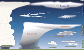 10 genera of cloud types (NOAA) |
Cloud GeneraThe easiest part of cloud identification is assigning a genera name to a cloud (or "general name" of clouds). |
| Stratus are low-level cloud layers that appear fairly uniform gray or white in color. Stratus clouds can appear as a dull, overcast days or appear in nebulosus form. In parts of the country they can persist for long periods of time. Status are the lowest-level cloud type and sometimes appear at the surface in the form of mist or fog.
Cumulus clouds are often described as scattered "puffy", "fluffy", or "cotton-like" in appearance and usually with have flat bases. The prefix cumulo- is derives from the Latin—meaning heap or pile. Cumulus clouds can low- to mid-level clouds with their bases typically at a uniform elevation. Cumulonimbus clouds are dense, towering vertical clouds that form from water vapor carried upward by powerful air currents. Cumulonimbus clouds are capable of producing lightning and other dangerous severe weather, including strong winds, tornadoes, and hailstones. Nimbostratus clouds are a multi-level, gray, often dark, amorphous, nearly uniform cloud that usually produces continuous rain, snow, or sleet. They typically do not produce lightning or thunder, but usually produces precipitation over a wide area. Nimbo- is derived from Latin word nimbus, meaning precipitation. Altostratus are mid-level clouds (about 8000–20,000 feet) that appear as a generally uniform gray sheet or layer of clouds. They appear lighter in color than nimbostratus but darker than cirrostratus. Altocumulus clouds are characterized by billowing white, globular or rounded masses or patches that appear with a darker level base, occurring at medium altitude, usually 6,500–20,000 feet (2–7 km). Altocumulus clouds typically develop with changing weather condition, sometime building up to form the larger, more ominous looking cumulonimbus (thunderstorm) clouds. Cirrostratus are high, thin clouds, partly transparent or translucent, and often cover large portions of the sky. Cirrostratus cloud sometimes produce white or rainbow-like colored rings, spots or arcs and halos of light around the Sun or Moon. Cirrocumulus are high-level clouds (16,500–45,000 feet [5–13 km]) that appear as a thin, white patches often describes as fleecy, with small puffy droplets or granulated shapes, sometimes with rippled appearance (called a mackerel sky). |
Cloud speciesThe genera name precedes the qualifying species or variety name. (Such as "cirrus uncinus" or "altocumulus castellanus." ) |
|
Cloud species are clouds grouped together by peculiarities in shape and internal structure. fibratus — (cloud species) Thin or detached clouds or cloud veil, consisting of nearly straight or irregularly curved filaments; applies mainly to cirrus and cirrostratus clouds. uncinus — (cloud species) Cirrus clouds often shape like a comma that terminates at the top in a hook or in a tuft. A cloud species which consists of fine hair-like strands, with hooked terminations. (Associated only with cirrus cloud formations.) castellanus — (cloud species) Clouds that present, in at least some portions of their upper parts, culliform (cauliflower-like) protuberances in the form of castle-like turrets. Some of the cloud turrets are higher than they are wide. The turret-like clouds are typically connected by a common base and seem to be arranged in lines. (Applies to cirrus, cirrocumulus, altocumulus, and stratocumulus clouds.) floccus — (cloud species) A cloud in which each unit is a small tuft with a culliform (cauliflower-like) appearance, often with a ragged lower part often accompanied by virga. They often formed by dissipation from larger cloud species. (Associated with cirrus, cirrocumulus, altocumulus, and stratocumulus cloud genera.) stratoformis — (cloud species) A horizontal sheet of clouds (altocumulus, stratocumulus, cirrocumulus)—Cirrocumulus stratiformis occurs as very small cirrocumulus clouds that cover a large part of the sky. This type of cloud always occurs in thin layers. There can be spaces or rifts between the individual cloudless in the layer. humilus — (cloud species) Slightly vertical cumulus clouds and that generally appear flattened. — Cumulus characterized by only a small vertical extent and appearing generally as if flattened. calvus — (cloud species) Cumulonimbus clouds in which some protuberances on the their upper rounded or Cumulo-form forms begin to change to to a diffuse, whitish, Cirro-form mass with somewhat vertical striations, or in which no Cirro-form parts can be distinguished. capillatus — (cloud species) Capillatus applies to cumulonimbus clouds that are characterized by the presence of distinctly fibrous or striated Cirro-form at their, frequently having the form of an anvil or an anvil grading or transformed into a plum. Cumulonimbus capillatus clouds are usually accompanied by showers or thunderstorm activity, often by squalls, and sometime hail. The frequently produce virga or sometimes mamma. |
Cloud VarietiesCloud varieties are cloud grouped by their characteristics of organization and visibility. |
|
intortus — (cloud variety) Cirrus clouds whose filaments that appear irregularly cured and entangled.
vertebratus — (cloud variety) Clouds that are arranged in a manner suggestive of vertebrae, ribs, or the skeleton of a fish. Applies mainly to cirrus or cirro-form clouds. undulatus — (cloud variety) A cloud composed of merged elements and organized in undulations. radiatus — (cloud varieties) Clouds that appear arranged in parallel bands that seem to converge toward a point on the horizon called “radiation points.” (Applies to cirrus, altocumulus, altostratus, stratocumulus, and cumulus.) lacunosus — (cloud variety) Thin cloud patches, sheets, or layers that are marked by rounded holes with fringed edges. (Applies to altocumulus and cirrocumulus.) duplicatus — (cloud variety) Cloud patches, sheets, or layers, that sometimes appear partly merged at slightly different levels or multiple levels. (Applies mainly to cirrus, cirrostratus, altocumulus, altostratus, stratocumulus,) perlucidus — (cloud variety) An extensive sheet, patch, or layer of clouds with well-defined but sometimes small spaces between small patchy cloud elements. The sun, moon, sky, or overlying clouds can be seen through the spaces between the small patchy cloud elements. (Applies to altocumulus, stratocumulus.) |
Accessory or Supplementary Cloud FeaturesThese terms are used to describe parts of clouds or distinctive cloud features. |
| arcus — (accessory) A thick horizontal accessory cloud with ragged edges, located on the lower front part of an advancing cloud or thunderstorm ( altocumulus or cumulonimbus) — Arcus clouds are low-level clouds typically associated with thunderstorms. They may have a dark, menacing appearance. incus — (accessory) The upper part of a cumulonimbus cloud that is spreading and organized in an anvil shape, having either a smooth, fibrous, or striated appearance. mamma — (accessory) Hanging protuberances that look like round pouches or hanging, breast-like protuberances on the under surface of a cloud. Other names used include mammatus clouds: mamma, mammatocumulus, or mammary cloud. pannus — (accessory) Patches or layered shredded accessory clouds below (attached or separated from the main cloud (nimbus, cumulus, cumulonimbus). The term pannus may apply to wall clouds and shelf clouds. ●A shelf cloud is a low, horizontal, sometimes wedge-shaped cloud associated with the leading edge of a thunderstorm’s outflow or gust front. Shelf clouds usually accompanied by potentially strong winds. Although shelf cloud may appear ominous, they normally do not produce tornadoes. pileus — (accessory) A small horizontal accessory cloud, in the form of a hood, that occurs above or on top of a cumulo-form cloud. They may take on a lenticular form. (Applies to cumulus and cumulonimbus.) velum — (accessory) A thin layer of accessory clouds pierced by or draped over cumulus or cumulonimbus clouds. volutus - also commonly called a roll cloud. Volutus are low-level, horizontal, tube-shaped clouds. Volutus clouds usually have a"rolling" appearance about a horizontal axis. They differ from shelf clouds by being completely detached from other cloud features. They appear completely detached from the cumulonimbus base (unlike the more common shelf cloud). Although often having a menacing appearance, roll clouds are not and do not produce tornadoes. |
Cloud Condensation and Precipitation |
Relative Humidity and Cloud Formation:Water that dissolves into the air becomes water vapor (described as humidity).Relative humidity is the amount of water vapor present in air expressed as a percentage of the amount needed for saturation at the same temperature. Depending on temperature and air pressure the air can hold up to about 4% water vapor, becoming saturated. Water vapor will condense to form clouds when it reaches saturation (called the dew point). The dew point as the temperature to which a humid air must be cooled to in order to reach saturation, assuming air pressure and moisture content are constant. As air temperature decrease, the dew point decreases. Also, as air pressure decreases, the dew point decreases. Cloud base is the the level in the atmosphere in which air temperature and pressure is low enough for the relative volume of water vapor to condense into water droplets. Below the freezing point, water vapor will sublimate directly into ice crystals. If the relative humidity of the air is not high enough for water to condense or sublimate, the air will remain clear of clouds. Water droplets that condense on cool solid surfaces is called dew. Ice crystals that form when water vapor sublimates directly into ice on cold surfaces is called frost. Precipitation:Mist is formed when a cloud of tiny water droplets hangs in the air at or near the earth’s surface that limits visibility.Fog is a layer of stratus (or irregularly shaped clouds) on or near the ground. In observation terms, if the visibility is greater than 1,000 meters this is mist. But if visibility is less than 1,000 meters this is fog. Precipitation is any product of the condensation of atmospheric water vapor that falls under the influence of gravity. Rain is liquid water that falls from the sky as water vapor condenses (releasing latent heat energy). Water droplets start forming as water condenses onto microscopic cloud-condensing nuclei —dust particles, aerosols, and pollutants in the air (see below). Eventually the droplets grow larger as they collect more water, increasing in mass that eventually allows them to fall to the ground. Types water precipitation include mist, drizzle, and rain (in increasing size). When atmospheric water reaches about 0.5 mm in diameter or larger it becomes a raindrop as soon as it reaches the size of 0.5mm. Typically, if raindrops grow larger than 4 millimeters, they will usually split into separate drops. Ice crystals sublimate directly from the air and can create crystal in the form of mostly microscopic needles, column, or plates. Ice crystals can grow to become snowflakes. Ice crystals and can contribute to forming an ice fog. High cirrus clouds are typically composed of a fog of ice crystals. Snow is a form of ice that falls from the sky. Each snowflake is a arrangement of ice crystals. A snowflake forms when water vapor sublimates (turns directly from a water vapor to solid ice). Snow crystals are mostly flat, hexagonal, six-pointed stars. Snowflakes can start as small, dust-like particles and grow into to complex large flakes up to about an inch in diameter. Ice Pellets (or sleet) are transparent pellets of ice in round or regular grains consisting of frozen raindrops or melted and refrozen snowflakes. Ice pellets are smaller than hailstones. Frozen drizzle forms smaller snow grains. Hail is precipitation that involves rounded ball of ice (hailstones) that falls from the sky. Hail forms as water droplets freeze and accumulate additional layers of ices as they rise and fall in updrafts in strong thunderstorms. Eventually they become to heavy and fall to the ground, typically along with heavy rain. Most hail is small, pea-to-marble sized, but can reach golf ball to baseball size in strong thunderstorms. Small hail are called snow pellets that are white, opaque grains of ice that are round or conical in shape. |
Dust Particles, Aerosols, and Pollutants |
The atmosphere can hold and carry an abundance of matter that is not water vapor. This material includes some solids and liquids that can precipitate or sublimate directly from the air similar to water vapor. These microscopic dust particles and aerosols can become cloud condensation nuclei. Aerosols, and Cloud Condensation Nuclei (CCNs)Cloud condensation nuclei (also known as cloud seeds) are small particles typically 0.2 µm, or 1/100th the size of a cloud droplet on which water vapor condenses. CCNs are aerosols. An aerosol is a colloidal suspension of microscopic particles dispersed in air or gas. The aerosols can be a combination of solid particles and liquid compounds (liquid water or organic residues). Atmospheric water vapor requires a non-gaseous surface to make the transition from a vapor to condensation. Smog is a type of air pollution. It is a mixture of smoke, gases, and chemicals that can makes the atmosphere appear thick and dark in color (red, orange, yellow, brown, or gray, depending on the type of pollutant and time of day, etc.). Smog is typically associated with urban pollution, but can be from wildfire smoke and other sources including agricultural activity. Not all smog is air man-made air pollution. For instance, the Smoky Mountains region of the Appalachian Mountains (eastern US) has a natural smog-like haze created by aerosols released naturally by pine forests in the region. Vog is a form of smog caused by volcanic activity. Large amounts of vog is generated when lava flows from Hawaii volcanoes spill into the ocean, creating a thick mix of gazes, particulates, and water vapor. Vog can be a significant cause of respiratory problems downwind from the volcanoes. Contrails are narrow, elongated cloud formed as jet aircraft exhaust condenses in cold air at high altitudes, indicative of upper level humidity and wind drift. Dust, Dust Storms, Sand StormsDust is any fine, dry powder consisting of tiny particles of earth or waste matter lying on the ground or on surfaces or carried in the air.Atmospheric dust is divided into different particle-size fractions: ● clay is particles less than .0.032 mm, ● silt is 0.032-0.063 mm, ● sand are particles larger an 0.063 mm. In arid regions, clay-size particles can be picked up and carried long distances; even across oceans. Silt and sand-size fractions typically move at or near the surface contributing to the formation of dunes where wind speeds slow down or wind flow is impeded (by mountains, fences, plants, etc.) , allowing gravity to allow dust to settle to the surface. Typically, sand particles bounce and roll along the surface in a process called saltation. The shape, size, and density of dust particles is a factor on how they can be transported by wind. Obviously, light fibrous organic material is easier to transport than grains of rock. As wind velocity increases, the larger the fraction of particulate matter can be lifted and transported by the wind. When wind blows across dry land it may pick up the dust-size fraction first. As wind speeds increase, silt, and then sand will be lifted. Stronger winds can lift and carry large fragments. For examples tornadic actively can lift tree branches, trash and other debris, even cows, cars, buses, bricks, parts of buildings, fish, frogs, and other materials, some of which can be carried long distances. Dust storms arise when a gust front or other strong wind blows loose sand and dirt from a dry surface. However, if the the wind is strong enough it can create sand storms. Most dust storms (or sand storms) appear as often ominous reddish or brownish clouds moving in in the lower level of the atmosphere. However, dust particles associated with some sandstorms have been observed in altitudes up to 5,000 feet (1524 m). How fast can sandstorms move? Sandstorms have wind speeds of at least 25 miles per hour (40 km) and can they can happen quickly, particularly along gust fronts of advancing storms. A dust Devil is a small whirlwind or air vortex over land, visible as a column of dust and debris. Dust devils can be small to massive, contributing to dust storms. Eruption clouds and clouds of volcanic ash (called tephra), gases, and water created by a volcanic eruption. Massive volcanic eruptions, can put massive amours of eruptive material high into the atmosphere that can drift for years around the planet. Massive eruptions can block out all the sunlight beneath ash clouds. For example, Mt. Pinatubo's eruption of 1991 in the Philippines created ash clouds that drifted hundreds of miles and actually contributed to global atmospheric cooling for several years after the eruption ended. Mount St. Helens eruption in 1980 in Washington blanketed large parts of the Pacific Northwest with volcanic ash, even leaving measure amount of ash as far away as Denver, Colorado. Afternoon sunlight and sunsets in the Midwest region were bright oranges and purples for several days after the peak of the eruption. |
Additional Cloud Information ResourcesThe World Meteorological Organization has produced an excellent description of clouds with their International Cloud Atlas which includes an image gallery and a glossary of cloud-related terms that are used on this website. The Audubon Society Field Guide to North American Weather was used to compile this website.See an extended glossary of meteorological terminology by the World Meteorological Organization, Internal Cloud Atlas; Glossary: |