
Torrey Pines State Nature Reserve |
Rock Formation Descriptions from the USGS Lexicon of Gelogy for the Torrey Pines area. |
| The USGS Lexicon of Geology has been compiled over the last century in an effort to provide consistent use of geologic names of rock formations as they appear in the literature. This has been done in order to maintain a systematic "phyogeny" of geologic names as they appeared in the literature. Many names have been introduced for the same rock units over the years, creating confusion, or refinements to the proper usage of the names as more information or interpretation becomes available. Names that appear in the Lexicon are the "official" names accepted by the US Geological Survey. |
The Delmar Formation, Torrey Sandstone, Ardath Formation and Scripps Formation are all middle Eocene age (around 49 to 45 million years old). These rock formations are part of a much larger package of Eocene age rock formations in the coastal San Diego region collectively designated as the La Jolla Group. In contrast, the Lindavista Formation and Bay Point Formation are very young (geologically speaking—having been deposited under very different circumstances during periods of changing sea levels throughout the ice ages of the Pleistocene Epoch). The Lindavista Formation is middle Pleistocene (roughly 0.7 to 1.0 million years old), and the Bay Point Formation is upper Pleistocene (about 120,000 to 700,000 years old). These formations are associated with ancient marine terrace deposits that have been described in different locations in the San Diego Bay region, of which at least six are partly preserved in the park. |
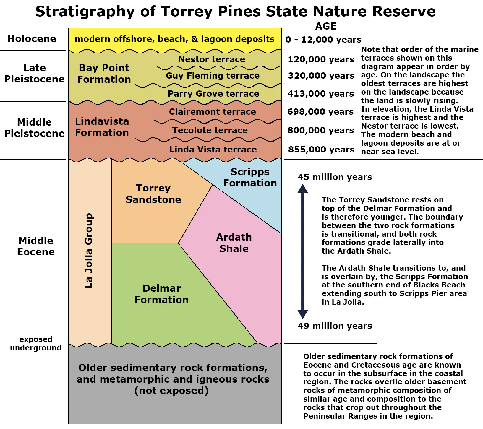 Fig. 7. Stratigraphy of the Torrey Pines Pines State Nature Reserve and park area (layers listed oldest to youngest—bottom to top). |
USGS Geologic Names Information System (GNIS) Lexicon summaries for the Delmar FormationThe quoted material below provides information about the original naming of the Delmar Formation accepted by the U.S. Geological Survey. These quotes provide original descriptions of its lithology, distribution, and thickness of the formation relative to other named rock units in the region. |
| Type section:
"Named from excellent exposures in sea cliff at town of Delmar, San Diego Co., southern CA (Hanna, 1926). Type section: short canyon 2 km south of Del Mar Railway Station, Del Mar 7.5-min quadrangle, San Diego Co., CA (Kennedy and Moore, 1971)." "Delmar sand. Sandstones, shales, and some beds, composed almost wholly of oysters, that might be considered limestone but usually the matrix surrounding the shells is argillaceous rather than calcareous. The sandstones are both coarse grained and fine grained, and grade into arenaceous shales. They are of prevailingly brown color, but often have a tinge of green, while a few beds have a reddish and purplish cast. Many shales are well stratified, but others grade into shaly sands. Bedding is irregular. Cross bedding is prominent in many places. Upper part contains more sand than lower part, and the sands are darker color than overlying Torrey sand, into which the Delmar sand grades. Thickness more than 200 feet. Is basal division of La Jolla formation in La Jolla quadrangle. Rests unconformably on Chico Cretaceous. Named from excellent exposures in sea cliff at town of Del Mar, San Diego Co., southern CA. (Hanna, 1926)" [See Figure 42.] Source: US geologic names lexicon (USGS Bull. 896, p. 594-595). "Delmar sand member of La Jolla formation. Lowest member of La Jolla. Underlies Torrey sand member. Maximum thickness about 100 feet, base not exposed. [Age is Eocene.] (Hertlein and Grant, 1939)." Source: US geologic names lexicon (USGS Bull. 1200, p. 1082). "Delmar Formation: lagoonal deposit; yellowish green sandy claystone interbedded with medium-gray coarse-grained sandstone; clays are expansive and landslide-prone; outcrops from Soledad Valley to Encinitas; grades vertically into Friars Formation from Los Peñasquitos Canyon to La Zanja Canyon and vertically and horizontally into the Santiago Formation in Encinitas; estimated to be 200 feet thick at type section; dated 49-47 Mya. Sources: Kennedy and Peterson, 1975." (Source: Brown, 1996). See the Selected References list below for full citations. |
USGS Geologic Names Information System (GNIS) Lexicon summaries for the Torrey SandstoneThe quoted material below provides information about the original naming of the Torrey Sandstone accepted by the U.S. Geological Survey. These quotes provide original descriptions of its lithology, distribution, and thickness of the formation relative to other named rock units in the region. |
| Type section: "Along Torrey Pines Grade where Coast Highway climbs from Sorrento Valley through Torrey Pines State Park, San Diego Co., CA." (Source: USGS GNIS Lexicon summary from: Kennedy and Moore, 1971) "Torrey sand [member] of La Jolla formation. Consists of sand, usually coarse, porous, and unconsolidated. Color is usually white to light brown. Is highly cross-bedded. Sand is clean, moderately well-rounded grains of quartz with varying amounts of feldspar, some muscovite and biotite and minor amounts of ferromagnesians. Thickness is more than 200 feet. Grades into overlying Rose Canyon shale [member] and into underlying Delmar sand [member]. Age is Eocene." (GNIS Lexicon summary from: Hanna, 1926) Torrey Sandstone of La Jolla Group: "Torrey Sand Member of La Jolla Formation of Hanna (1926) is adopted and raised in rank to Torrey Sandstone of La Jolla Group. Is exposed from approximately 5 km north of Encinitas to Torrey Pines State Park 20 km south, and from coast to about 8 km inland. Has maximum thickness of 60 m. Although unit contains few poorly preserved fossils, its middle Eocene age is firmly established by its inter-fingering relationship with the Ardath Shale of the La Jolla Group." (GNIS Lexicon summary from: Kennedy and Moore, 1971) "Torrey Sandstone: tidal flat and beach deposits; white to pale brown, medium to coarse-grained sandstone interbedded with medium-gray coarse-grained sandstone; outcrops from Torrey Pines Golf Course to Encinitas; grades vertically and horizontally into the Santiago Formation in Encinitas; estimated to be 200 feet thick; estimated 49-47 Mya (based on Ardath Shale and Delmar Formation). Sources: Abbott, 1999; Kennedy and Peterson, 1975; Tan and Kennedy, 1996." (Brown, 1996) See the Selected References list below for full citations. |
USGS Geologic Names Information System (GNIS) Lexicon summaries for the Ardath ShaleThe quoted material below provides information about the original naming of the Ardath Shale accepted by the U.S. Geological Survey. These quotes provide original descriptions of its lithology, distribution, and thickness of the formation relative to other named rock units in the region. |
| Type section: "on the east side of Rose Canyon, 800 m south of Ardath Road intersection with Interstate Route 5, La Jolla quadrangle, San Diego Co., CA." (Kennedy and Moore, 1971). "Ardath Shale: continental shelf deposits; olive-gray (unweathered) to yellowish brown (weathered), weakly fissile silty shale with thin beds of medium- grained sandstone; some expansive clays and landslide-prone; estimated to be 230 feet thick at type section; outcrops from Mission Bay to Torrey Pines State Park; correlates with the middle part of the Santiago Formation; dated 49-45 Mya. Sources: Abbott, 1999; Kennedy and Peterson, 1975." (Brown, 1996) "Named as formation in La Jolla Group for exposures on east side of Rose Canyon, where its type section is 800 m south of Ardath Road intersection with Interstate Route 5, La Jolla quad, San Diego Co, CA. Previously included as part of Rosewood Canyon Member (Hanna, 1926) of La Jolla Formation (Clark, 1929). Consists of uniform, weakly fissile olive-gray silty shale. Upper part contains thin beds of medium-grained sandstone, and concretion beds with molluscan fossils. Estimated 70 m thick at its type. Conformably overlies Mount Soledad Formation (new); conformably underlies and intertongues with Scripps Formation (new), interfingers with Torrey Sandstone (all of La Jolla Group). Assigned early middle Eocene age, based on fossil evidence. " (USGS GNIS Lexicon summary from: Kennedy and Moore, 1971) "Fossil lists of gastropods and pelecypods with locations from Ardath Shale indicate "Domengine Stage" (middle Eocene)." (USGS GNIS Lexicon summary from: Givens and Kennedy, 1979) |
| Below is the USGS Geologic Names Information System (GNIS) Lexicon summary for the Scripps Formation. |
| "Named as formation (of 6) in La Jolla Group for exposures along sea cliff north of Scripps Institution of Oceanography. Type section is on north side of mouth of Blacks Canyon about 1 km north of pier at Scripps Institution, San Diego Co, CA . Rocks have previously been included as part of Hanna's (1926) Rose Canyon Shale Member of former La Jolla Formation. Consists of pale-yellowish-brown medium-grained sandstone, containing in lower two-thirds three cobble-conglomerate beds. Is 67 m thick at type. Conformably overlies Ardath Shale (new) and in places Torrey Sandstone (both of La Jolla Group). Conformably underlies Friars Formation (new) of La Jolla Group. Age is middle and late Eocene based on molluscan fossils." (Kennedy and Moore, 1971). "The outcrop exposure, which is approximately 100 m (330 ft) high by 1.7 km (~1 mi) long" (Stright and others, 2014) |
USGS Geologic Names Information System (GNIS) Lexicon summaries for the Lindavista FormationThe quoted material below provides information about the original naming of the Lindavista Formation accepted by the U.S. Geological Survey. These quotes provide original descriptions of its lithology, distribution, and thickness of the formation relative to other named rock units in the region..Note that the designation as Early Pleistocene of the Lindavista Formation has changed. In the older literature the boundary between Late and Early Pleistocene was considered around 0.8 million years in the literature, but it is now pushed back to 1.8 million years. As a result, both the Lindavista Formation and the Bay Point Formation are now both considered Late Pleistocene in age, but they are still presented here as separate rock formations because of their differences in appearance and distribution. |
| Type section: "Not designated. Named by Hanna (1926) after Lindavista railroad junction (Lat. 32 deg. 53 min. N., Long. 117 deg. 11 min. W.) La Jolla 15-min quadrangle, San Diego Co., CA" ((USGS GNIS Lexicon summary from: Moore, 1972). "Lindavista Formation of Hanna (1926) is adopted. Named after the Lindavista railroad junction (32 deg 53'N, 117 deg 11'W) La Jolla 15' quad, San Diego Co., CA. Generally stands at altitude of 120 m in San Diego area; where cut by Rose Canyon fault, stands upward to 250 m. Is reddish-brown marine-terrace deposit, 2 to 10 m thick. Overlies the San Diego Formation of Pliocene age; underlies the Bay Point Formation of late Pleistocene age. Age is early Pleistocene based on stratigraphic relations." (USGS GNIS Lexicon summary from: Moore, 1972). Lindavista Formation: "[Probably named for Southern Pacific Lindavista railroad siding, La Jolla 15' quad, San Diego Co., CA]. Consists of fine and coarse arkosic sand, gravel, and well-rounded boulders that range in size to a foot or more. Color is prevailingly red and brown. Boulders are largely from the Eocene Poway conglomerate. Thickness averages less than 25 feet and is over 100 feet on beach ridges. Overlies the Poway conglomerate and San Diego formation. Is unfossiliferous. Age on map legend given as Quaternary. " ((USGS GNIS Lexicon summary from: Hanna, 1926; Moore, 1972) "The Lindavista Formation, named for exposures near the Lindavista railroad siding (Hanna, 1926: 218), consists of several meters of iron-red, moderately indurated dirty sand and pebble-cobble conglomerate. Along the eastward extent of the formation, the sandy facies interfingers with terrestrial gravels which are probably deltaic in origin. In addition, the formation is commonly characterized by pea-sized hematitic concretions on weathered surfaces (Hanna, 1926: pi. 23; Emery, 1950). The lithology at the fossil localities (see also Register of Localities) varies from a very modern-looking clean gray laminated beach sand to a fossiliferous conglomerate rich in heavy minerals (Figure. 2). The Lindavista Formation blankets the Linda Vista Terrace, a broad and essentially planar, slightly westward sloping wave-cut surface extending from the present coastline nearly fifteen kilometers inland, where it terminates at the base of the foothills. Remnants of this formation are exposed on terraces from northernmost Baja California (Minch, 1967: 1157, 1170) to areas near Oceanside in San Diego County (Emery, 1950: 214, and pi. 29). The most prominent features of the Linda Vista Terrace are the three ancient beach ridges which approximately parallel the present coastline. These have been interpreted as still stands during the marine regression which followed cutting of the terrace (Peterson. 1970: 122). Marine sediment along the eastern margin of the wave-cut surface was deposited earlier than that toward the coast." (Kennedy, 1973) |
USGS Geologic Names Information System (GNIS) Lexicon summaries for the Bay Point FormationThe quoted material below provides information about the original naming of the Bay Point Formation accepted by the U.S. Geological Survey. These quotes provide original descriptions of its lithology, distribution, and thickness of the formation relative to other named rock units in the region. |
Type locality: none designated. |
Selected References and ResourcesAbbott, P. L., 1999, The Rise and Fall of San Diego: 150 Million Years of History Recorded In Sedimentary Rocks: Sunbelt Publications, San Diego, CA, 231 p.Beachapedia, 2018, State of the Beach/State Reports/CA/Beach Erosion: Beachapeida.org: http://www.beachapedia.org/State_of_the_Beach/State_Reports/CA/Beach_Erosion Brown, J.E., [~1996], Geologic Formations of Western San Diego County: Geiconsultants.com, 7 p. [no longer available online]. California Geological Survey, 2020, Data Viewer (Geologic Map of California): https://maps.conservation.ca.gov/#dataviewer. Givens, C.R., and Kennedy, M.P., 1979, Eocene molluscan stages and their correlation, San Diego area, California, IN Abbott, P.L., ed., Eocene depositional systems, San Diego, California; [field trip no. 18]: Geological Society of America Field Trip Guidebook, Joint Fall field trip of Society of Economic Paleontologists and Mineralogists, Pacific Section, and Geological Society of America, [92nd] annual meeting, San Diego, CA, November 8-9, 1979, no. 18, p. 81-95. Google Earth, [2020]: https://www.google.com/earth/ Hanna, M.A., 1926, Geology of the La Jolla quadrangle, California: University of California Publications in Geological Sciences, v. 16, no. 7, p. 187-246, (incl. geologic map, scale 1:62,500). Hertlein, L.G., and Grant, U.S., IV, 1939, Geology and oil possibilities of southwestern San Diego County: California Journal of Mines and Geology, v. 35, no. 1, p. 57-58. Imbrie, J., Hays, J.D., Martinson, D.G., McIntyre, A., Mix, A.C., Morley, J.J., Pisias, N.G., Prell, W.L., Shackleton, N.J., 1984, The orbital theory of Pleistocene climate: Support from a revised chronology of the marine δ18O record, in Berger, A., Imbrie, J., Hays, J., Kukla, G., and Saltzman, B., eds., Milankovitch and climate: Understanding the response to astronomical forcing: Dordrecht, D. Reidel Publishing Company, p. 269-305. Kennedy, G. L., 1973, A marine invertebrate faunule from the Lindavista Formation, San Diego, California: Transactions of the San Diego Society of Natural History, V. 17, no. 10, p. 119-127. Kennedy, M.P. and Moore, G.W., 1971, Stratigraphic relations of Upper Cretaceous and Eocene formations, San Diego coastal area, California: American Association of Petroleum Geologists Bulletin, v. 55, no. 5, p. 709-722. Kennedy, M.P. and Peterson, G.L., 1975, Geology of the San Diego Metropolitan Area, California: California Division of Mines and Geology, Bulletin 200, 56 p. (with geologic maps). Kennedy, M.P. and Tan, S.S., 2005, Geologic map of the San Diego 30' x 60' quadrangle, California: California Department of Conservation (see next reference). Kennedy, M.P. and Tan, S.S., 2008, Geologic map of the San Diego 30' x 60' quadrangle, California: California Geological Survey Regional Geologic Map No. 3., Map Scale: 1:100,000, https://ngmdb.usgs.gov/Prodesc/proddesc_84173.htm; with pamphlet: https://ca.water.usgs.gov/projects/sandiego/data/gis/geology/kennedy2008/RGM3_San_Diego_2008_Pamphlet.pdf. Kern, J.P., Stump, T.E., and Dowlen, R.J., 1971, An upper Pleistocene marine fauna from Mission Bay, San Diego. California. Trans. San Diego Society of Natural History Bulletin. 16, p. 329-338. Kern, J. Philip and Rockwell, Thomas K.,1992, Chronology and Deformation of Quaternary Marine Shorelines, San Diego County California: In, Quaternary Coasts of the United States: Marine and Lacustrine Systems, SEPM (Society for Sedimentary Geology) Special Publication No. 48, p. 377-382. Meldahl, K.H., 2015, Surf, Sand, and Stone: How Waves, Earthquakes, and Other Forces Shape the Southern California Coast. Oakland, CA: University of California Press, 222 p. Meldahl, K., [2019], Geologic Evolution of San Diego County's Coasts and Lagoons: Mira Costa Community College (fieldtrip report): http://h-m-herms.net/My%20Web/SELC-D/Geology/San_Diego_Coast%20(SEL%20docent%20version).pdf. Moore, G.W., 1972, Offshore extension of the Rose Canyon Fault, San Diego, California, IN Geological Survey Research 1972: U.S. Geological Survey Professional Paper, 800-C, p. C113-C116. Mueller, K., [2002?]. Origins of Coastal Uplift in San Diego and Orange Counties: Huge Blind Thrusts or Aseismic Rift Shoulder? USGS Research Grant, Final Report: Award Number 01HQGR0031: https://earthquake.usgs.gov/cfusion/external_grants/reports/01HQGR0031.pdf Muhs, Daniel R., Webmiller, J.F., Simmons, K.R., and York, L.L., 2004, Quaternary sea-level history of the United States: in The Quaternary Period in the United States, Gillespie, A.R. and Porter, S.C., Developments in Quaternary Science, v. 1, Elsevier Publ., p. 147-183. NOAA, 2020, Climatological Datasets: National Oceanographic and Atmospheric Administration (NOAA), National Centers for Environmental information: https://www.ncdc.noaa.gov/data-access/paleoclimatology-data/datasets. San Diego History Center, 2020, Timeline of San Diego History: https://sandiegohistory.org/archives/biographysubject/timeline/ Schulz, Marjorie, Lawrence, C, Muhs, D, Prentice, C., and Flanagan, S., 2018, Landscapes from the Waves—Marine Terraces of California: USGS Fact Sheet: https://pubs.usgs.gov/fs/2018/3002/fs20183002.pdf . Spratt, R.M. and Lislecki, L.E., 2016, A Late Pleistocene sea level stack: Climate of the Past, v. 12, p. 1079-1092. Stamm, N., 2000, U.S. Geological Survey, Geolex—Significant Publications: https://ngmdb.usgs.gov/Geolex/search. Stright, L. Stweart, J. Camion, K. and Graham, S., 2014, Geologic and seismic modeling of a coarse-grained deep-water channel reservoir analog (Blacks'Beach, Lajolla, California: AAPG Bulletion 98 (4), p. 695-728. Tan, S.S. and Kennedy, M.P., 1996, Geologic Maps of the Northwestern Part of San Diego County, California, Open File Report 96-02, California Division of Mines and Geology. Torrey Pines Association website [2020]: https://torreypines.org/. This website has a wealth of information not presented here, particularly about the wildlife biology, ecology, geology, and history and management of the Torrey Pines State Nature Preserve. U.S. Board on Geographical Names, U.S. Geological Survey, [2020], Domestic Names [This database provides names, coordinates, and elevations of named places]: https://www.usgs.gov/core-science-systems/ngp/board-on-geographic-names/domestic-names. |
| https://gotbooks.miracosta.edu/fieldtrips/torrey_pines/USGS_Lexicon.html | 9/10/2020 |