Geomorphic Expression Of Fault Zones |
| Landscape Features Associated With Strike-Slip and Oblique-Slip Fault Zones: Fault-Related Terminology With Illustrations. |
| Earthquake focus Epicenter depth of earthquakes surface rupture |
Click on images for a larger view. |
|
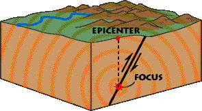 Fig. 1. An epicenter is the location where the first shock waves reach the surface above where an earthquake rupture begins at the focus. |
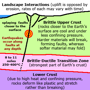 Fig. 2. Brittle vs. ductile zones within the earth's crust. |
|
| deformation folds types of faults map orientation (3D) strike and dip Figure 1 illustrates the different kinds of faults and folds (geologic stuctures) and how they are illustrated on geologic maps. |
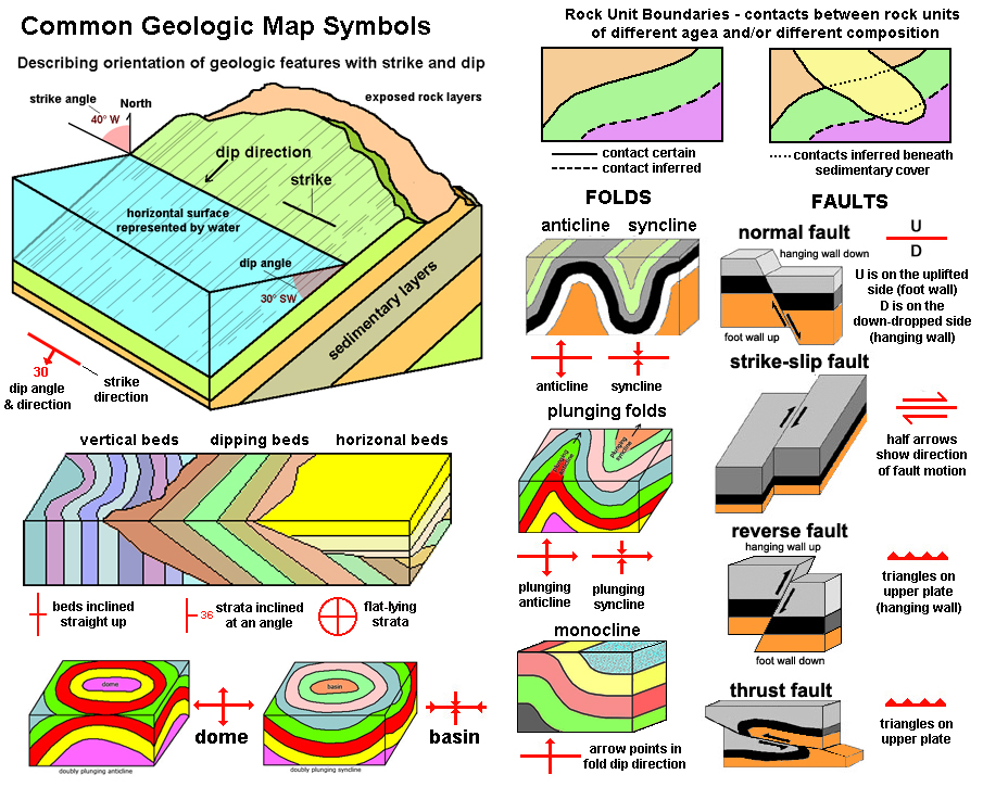 Fig. 3. Terminology used to describe fold, faults and geologic structures on maps. |
| Fault Zone Features | 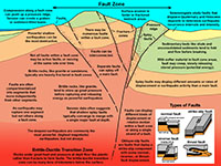 Fig. 4. Fault zone features in cross section illustrated. |
| Compression, Extension, and Shear | 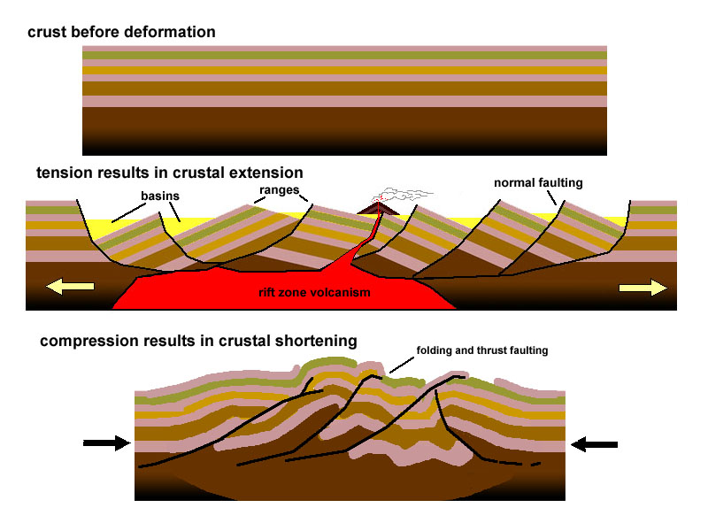 Fig. 5. Large scale features associated with crustal extension and compression. |
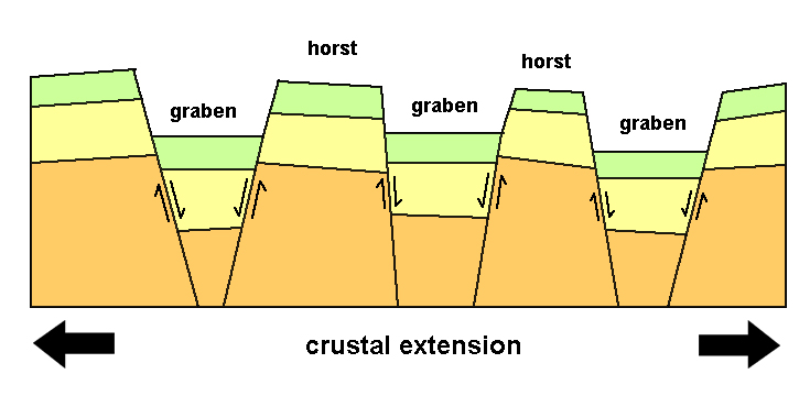 Fig. 6. Origin of horst and graben structures caused by extension and faulting of brittle crustal rocks. |
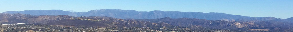
Geomorphic Expression: Landscape Features Associated With FaultsThis section is an introduction to fault-related terminology as it relates tothe geomorphic expression of faults on the landscape surface.California is famous for its active fault systems, many of the largest faults are strike-slip faults. It is also a dry region, so surface features associated with earthquake fault motion tend to be very well preserved and visible compared to fault- and fold-related features in wetter climates where forest cover disguises feature or erosion rapidly erodes away evidence of ground rupture along falults. |
| Strike Slip and Oblique Slip Faults |  Fig. 7. Geomorphic features associated with geologically active strike-slip faults. |
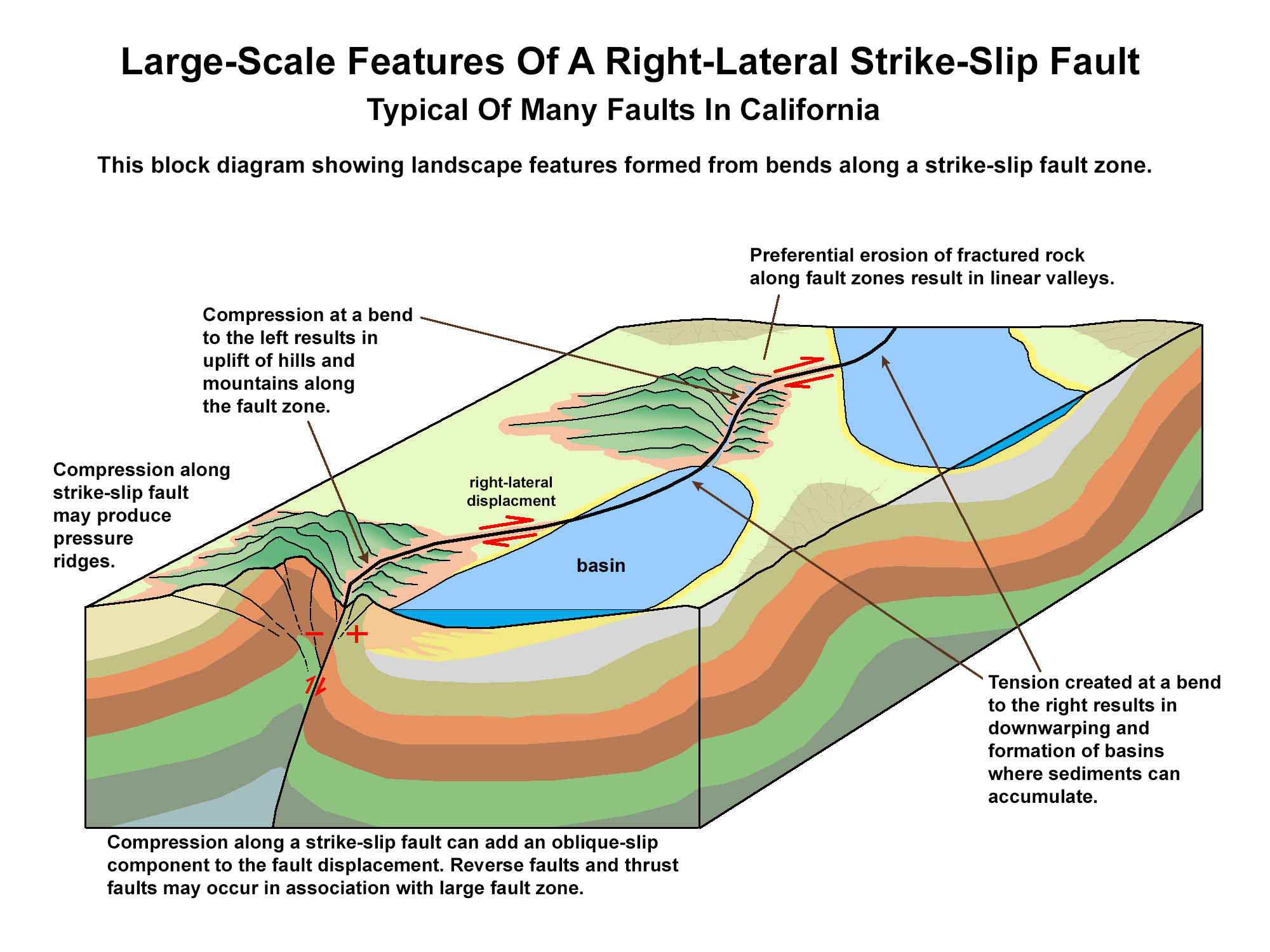 Fig. 8. Large-scale landscape features associated with strike-slip faults. |
Geomorphic Expression: Landscape Features Associated With Strike-Slip Fault ZonesBelow are examples of landscape features associated with faults that display strike-slip offset (Figure 7 and 8). A fault line is the trace of a fault plane intersects the ground surface or other surfaces, such as on a sea cliff, road cut, or in a mine shaft or tunnel. A fault line is the same as fault trace. Faults lines can often be difficult to resolve from general surface observation due to cover by younger sediments, vegetation, and human-induced landscape modifications. They may be revealed by a color change in the soil, but other means are necessary to be sure it is a fault (geologists often dig trenches to study faults). Fault lines are commonly associated with linear features on landscapes, but not all linear features are associated with faults. An escarpment is a long, more or less continuous cliff or relatively steep slope facing in one general direction, separating two level or gently sloping surfaces. Escarpments are produced both by faulting offset or by erosion of cliff-forming rock bodies along river valleys. A fault scarp is an escarpment or cliff formed by a fault that reaches the Earth’s surface. Fault scarps tend to be modified by erosion after the faulting occurred. Low scarps in alluvium are tell-tale signs of Holocene fault rupture activity. A modified scarp is an older fault scarp that has been significantly modified by surface erosion and mass wasting. A pull-apart basin is a graben structure created when two roughly parallel strands result in shearing tension, causing the area between the two fault strands to sink relative to the opposing sides where uplift may be occuring (such as between horsts or shutter ridges). A sag pond or (sag) is a natural depression associated with a fault or associated with a pull-apart basin along a fault system can hold water, even temporarily. Folding and faulting can produce swales—a low or hollow place, especially a marshy depression between ridges. A linear drainage is a stream drainage that follows the trace of a fault. Stream alignment may be a result of strike-slip fault motion. Streams tend to follow fault zones because the sheared and pulverized rock tend to be easily eroded compared to the surrounding solid bedrock. A shutter ridge is a ridge formed by vertical, lateral, or oblique displacement on a fault that crosses an area having ridge and valley topography; the displaced part of the ridge shuts in the valley. Shutter ridges typically are found in association with offset drainages. A horst is an uplifted block bounded by two faults with either some normal or reverse (or oblique-slip) motion resulting a raised ridge relative to troughs (grabens) on either side. A linear ridge is a long hill or crest of land that stretches in a straight line. It may indicate the presence of a fault or a fold (such as an anticline or syncline). If it is found along a strike-slip fault it may be a shutter ridge or a pressure ridge. A linear scarp is a straight escarpment where there is a vertical component of offset along a fault (either normal or reverse). Linear scarps may also form when preferential erosion removes softer bedrock or soil along one side of a fault. A linear mountain front can be associated with a linear scarp, but on a larger scale. A faceted spur is a mountain ridge or spur that ends in a triangular face, known as a triangular facet, with a broad base and an apex pointing upward. he triangular facet is usually a remnant of a fault plane and it and its associated faceted spur are the result of faulting. An hourglass canyon usually can be found betwen faceted spurs along a linear mountain front. The lower part of canyon appear as a steep, narrow gorge at the mountain front that widens into a goblet shape farther into the mountains. Fresh scarps may appear cutting across the alluvial fan at the mouth of the canyon if a significant earthquake has occurred. Hourglass canyons are evidence of recent and prolonged uplift uplift along a mountain front. A linear trough is a straight valley that may be bounded by linear fault scarps. A linear trough may be a graben or a rift valley and may be modified by erosion. Linear troughs are commonly graben-like features and are often called pull-apart basins where they occur in large fault zones. An offset drainage is a stream that displays offset by relatively recent movement along a strike-slip fault. A better term is deflected drainage. Fault displacement can create a saddle between deflected or beheaded stream drainages. A beheaded stream is a drainage that has been cut off by strike-slip displacement. A side-hill benches is a step-like surface on the side of a hill or mountain. Both recent fault activity or erosional differences of bedrock lithology across a fault may produce side-hill benches and associated linear scarps. Side-hill benches may also form from slumping that may or may not be associated with faulting. Offset historic infrastructure reveals the location of major faults that are slowly creeping. Offset old fences, broken sidewalks and walls, cracks in old cement and asphalt are common along some of the creeping faults in central California. Soil and vegetation changes: Faults often only express themselves at the surface by changes in the composition of the soil, derived from different bedrock regolith on opposite sides of a fault. The difference in soil composition and character may also express in differences in plant communities on opposite sides of a fault. Care needs to be taken when using vegetation as in indicator because of land-use history. For instance old fence lines, agricultural fields, and the margins of wildfire burn areas may create landscape impression that may not be fault related. The boundary between bedrock and alluvium is often reflected in vegetation changes. Expressions of Fault Movement On Rocks In Fault ZonesFault motion fractures, pulverizes, and crushes rock into fragments and powder. Fault zones may be filled with crushed and broken rock through a wide area where large amounts of fault slip have taken place over millions of years. Where exposed by erosion or in cuts associated with construction, material impacted by crushing and shearing fault motion has distinct characteristics:Slickensides are a polished and striated (scratched) rock surfaces produced by friction along a fault; they appear a scratches on a rock surface. Fault gouge is the mix of angular rock fragments and ground-up rock material in an fault zone; typically uncemented in active fault zones. Mylonite is a fine-grained metamorphic rock, typically layered or banded, resulting from the grinding or crushing of other rocks. Fault breccia is a mix broken rock fragments (angular grains to massive blocks and boulders) found in a broad fault zone. |