|
Introduction to Earth Science |
| Quiz 3 - Basic Geologic Principles & Maps |
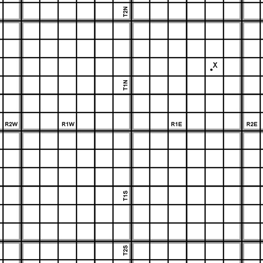
1. Geochronology is the study of the age of rocks. According to the geologic time scale, if it was determined that a rock containing fossils was precisely 180 million years old, what geologic time period would that be from? a. Late Permian b. Early Triassic c. Early Jurassic d. Late Cretaceous 2. The rock cycle conceptually includes aspects of which of the following: a. Earth materials may change from one form to another over the passage of geologic time. b. Igneous, sedimentary, and metamorphic rocks all form from different processes and under under unique conditions. c. Tectonic forces are responsible fore the gradual uplift of mountains, both on and land and the seafloor. d. all of the above. 3. What would explain why beach sand is dominated by the mineral quartz? a. Quartz is composed of silicon and oxygen, the two most abundant elements in the Earth's crust. b. Quartz is a very hard and durable mineral, and is more resistant to weathering and erosion than other minerals. c. Minerals other than quartz tend to break down into tiny particles or dissolve and be carried away by wave action, whereas grains of quartz stay behind. d. all of the above. 4. A rock formation is a rock unit that is distinctive enough in appearance that a geologist can distinguish it from other surrounding rock layers. A named rock formation must also be thick enough and extensive enough to plot on a geologic map. Large bodies of rocks that display characteristic layers are called: a. unstratified. b. strata. c. metamorphic. d. all of the above. 5. The relative age of a volcanic intrusion might best be determined by: a. the Law of Original Horizontality. b. the Law of Superposition. c. the Law of Cross-Cutting Relationships. d. the Law of Angular Unconformities. 6. The arrow in this view of the Grand Canyon points toward: 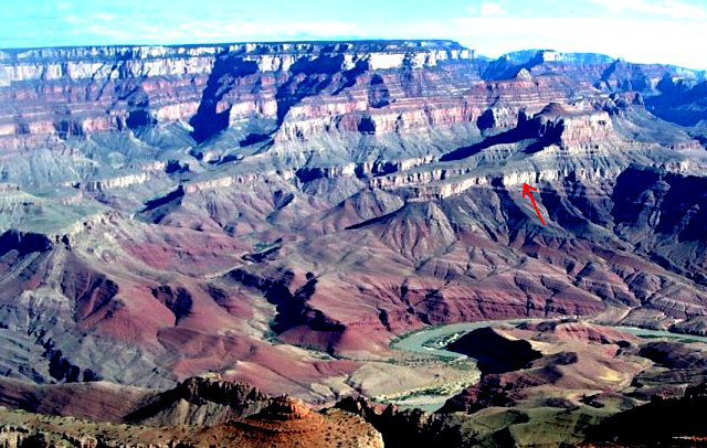 a. a disconformity. b. an angular unconformity. c. a nonconformity. d. a conformable contact. e. all of the above. 7. Unconformities are caused by relative changes in sea level over time. When sea level falls, erosion tends to strip away sediments exposed on land. When sea level rises, sediments tend to be deposited and preserved on the seafloor. When sea level falls it it called: a. a transgression. b. a regression. c. angular unconformity. d. nonconformity. 8. Which of the following is NOT a form of relative dating? a. Using the Laws of Original Horizontality, Superposition, Cross-Cutting Relationships to compare the ages of rock layers. b. Placing geologic layers or events in their proper sequence or order without knowing their exact age in years. c. Comparing fossils found in sedimentary rock layers to rock layers found in different locations. d. Using radioactivity to find the age of a rock. 9. A graphic representation of the intersection of the geological features in the subsurface with a vertical plane is called a: a. geologic map. b. cross section. c. geophysical survey. d. legend. 10. Geophysical exploration methods involve the use of: a. sound (shock waves produced by explosives or machines making sounds to penetrate the ground). b. measurements using electricity and radar to penetrate the ground. c. measurements of variations in gravity and magnetism. d. all of the above. 11. Absolute dating is a general term applied to a range of techniques that provide estimates of the age of objects, materials, or sites in real calendar years either directly or through a process of calibration with material of known age. One method uses the radioactive decay of Uranium isotope 238U (the unstable parent isotope). Slowly over billions of years, this radioactive parent isotope decays to form what daughter isotope? a. 206PB (stable lead isotope) b. 87Sr (stable strontium isotope) c. 235U (stable uranium isotope) d.40K and 40Ar (potassium and argon stable isotopes) 12. What is the half-life of radioactive 14C (radioactive carbon-14 isotope)? a. 1.3 billion years b. 47 billion years c. 710 million years d. 5,730 years. 13. An explanation of symbols used on map, including colors, lines, icons, and symbols is called: a) bibliography. b) scale. c) legend. d) orientation. 14. The measurement or mapping of water depth (sea bed) beneath oceans, lakes, or other bodies of water is called: a. bathymetry. b. topography. c. relief. d. sonar. 15. Topography is the arrangement of the natural and artificial physical features of an area. A topographic map is a graphical representation of a landscape showing selected natural and artificial landscape feature. The amount of change in elevation on the surface of the Earth is called: a. contours. b. relief. c. height. d. ceiling. 14. The angular distance of a place north or south of the earth's equator, usually expressed in degrees and minutes, and is called: 15. One degree of latitude anywhere on Earth is equivalent to: 17. It is difficult to make a flat map of the spherical globe. A commonly used type of map of the Earth that projects lines of longitude and latitude as a perpendicular grid of squares (and does not show lines converging at the north and south poles) is called a: 18. Public Land Survey System was used to subdivide land in most of the United States (excluding the 13 Colonies and Texas). The surveying involved measuring a grid of lines east-to-west and north-to-south starting with a designated initial point (such as a mountain peak like Mt. Diablo in central California between San Francisco and Sacramento). From an established initial point, a line running east-to-west was surveyed before lines north-to-south were mapped. This first survey line running east-to-west is called: 19. A township is an area that has been mapped using the Public Land Survey System (PLSS). The name of the township usually includes the name of a town, ranch, or landscape feature in the area when it was first surveyed. Today is still commonly used for political boundary designations. In the PLSS most townships encompass an area of: Use this map to answer the question below (See Figure 3-80 for an explanation). 20. In your new CSI investigative reporting job, you received a call from a desperate Nebraska farmer that says an unusual flying object came out a cloud and crash landed in one of his corn fields. He sends you a fax with part of a topographic map with a dot (next to an "X") showing where "the thing" has landed. You now have to report to the proper authorities how to find this location. It is located at: |