
Chapter 13 - Glaciers & Glaciation |
| Glaciers occur in regions with average annual temperatures are below freezing—such as in high mountain ranges and in polar regions. In the geologic past, great glaciers covered large portions of North America and Europe where forested landscapes and cities exist today. In contrast, Antarctica and Greenland are still experiencing ice age conditions today. However, Around the world glaciers, are melting and retreating, including the great ice caps in Antarctica and Greenland. This melting is a continuation of glacial retreat that began at the end of the peak of the last ice age (called the Wisconsin Stage in North America). Since the end of the last ice age, sea level has risen hundreds of feet around the world, and sea level is still rising. This chapter reviews landscape features associated with processes and landscape features of existing glaciers, and examines landscape features from past glaciation periods where continental glaciers once covered large regions of North America and Europe. |
 |
|
| Fig. 13-1. Glaciers and ice caps hold more freshwater that all steams, rivers, lakes, and groundwater combined. | ||
What Are Glaciers?A glacier is a slowly moving mass or river of ice formed by the accumulation and compaction of snow over many years, forming on mountains or land masses near the Earth's poles. The difference between and ice field and a glacier is that glaciers move under the influence of gravity. The glaciers form from the accumulation of frozen precipitation (primarily snow) of thousands to millions of years. As frozen precipitation accumulates, it compacts (degases) into solid, clear blue, glacial ice. Although ice is a solid, under pressure it deforms and fractures easily. Ice on the surface of a moving glacier is highly fractured. However, at a depth of about 80 feet (25 meters) the weigh of overlying ice will cause it to deform plastically, and if there is a slope, the ice will begin to flow downslope.Glaciers occur in polar regions and in mountainous regions where at high elevations subfreezing temperatures are persistent having an annual average freezing temperature below 0° Celsius (or 32° Fahrenheit) and where summer melting does not remove ice from previous winter seasons. Glaciers also only persist in regions where precipitation constantly contributes more frozen precipitation than melts on average. |
 Fig. 13-2. Greenland is covered with a great ice sheet. This satellite view shows much of it surrounded with sea ice. |
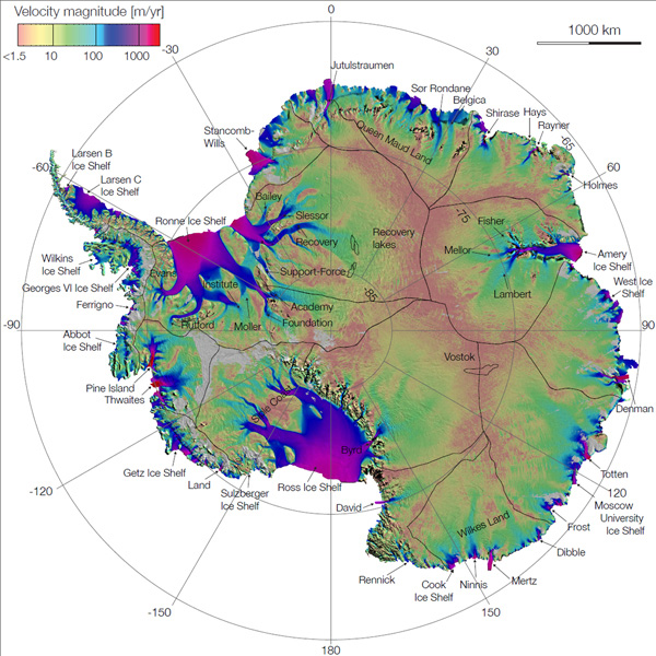 Fig. 13-3. Map of Antarctica (Earth's 5th largest continent) showing ice sheets, ice caps, and ice shelves. |
Types Of GlaciersThere are several types of glaciers.An ice sheet is the layer of ice covering extensive regions of the world, notably Greenland (Figure 13-2) and Antarctica (Figure 13-3). Antarctica is mostly covered with ice sheets, but also has has several vast ice shelves in addition to its massive ice sheets and ice caps in its mountainous regions (Figure 13-3). An ice shelf is a thick floating platform of ice that forms where a glacier or ice sheet flows down to a coastline and onto the ocean surface. An ice cap an extensive dome-shaped or plate-like perennial cover of ice and snow that spreads out from a center and covers a large area, especially of land. Examples include upland glacial regions in Iceland and the Canadian and Alaska coastal mountain ice caps. A alpine glacier is a glacier confined by the walls of a valley in a mountainous region. Alpine glaciers are also called valley glaciers. Snow accumulating in mountainous regions turns to glacial ice, and once thick enough begins to flow down valleys. The ice carves the floor and walls of the valley eroding large quantities of rock and transporting downslope (an example in Figure 13-5). |
 Fig. 13-4. Ice caps (left) and valley glaciers (right) in British Columbia. In this satellite view, ice is flowing from accumulation sites in the mountainous uplands, flowing down valleys in to the ocean. The valley glacier becomes a tidewater glacier when it reaches the ocean. |
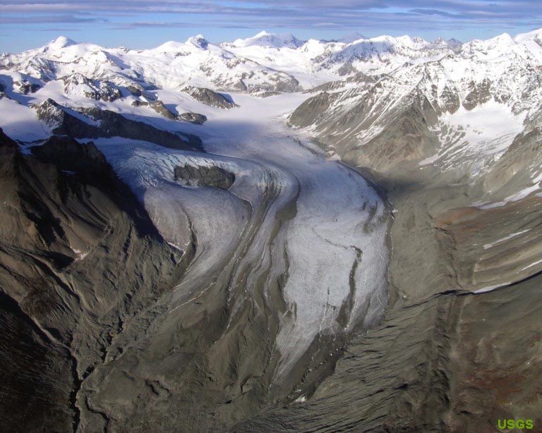 Fig. 13-5. Moving ice (glaciers) erodes bedrock and carry large quantities of sediment. This view shows Gulkana Glacier, a valley glacier in Alaska. Large layers of sediment along the glacier are moraine left behind by previous glacial advances. |
Piedmont and Tidewater GlaciersA piedmont glacier is a thick, continuous ice sheet formed along the base of a mountain range formed by the spreading out and coalescing of valley glaciers supplying ices from higher mountain elevations. Figure 13-6 shows the Malaspina Piedmont Glacier in Alaska. An ice cap region in the Elias Mountains of southern Alaska and Yukon Territory provide glacial ice via valley glaciers to the Malapina Piedmont Glacier that spread out across the lowlands along the Gulf of Alaska. In the low country, the piedmont glacier gradually melts, leaving large amounts of rock material to accumulate along with remnants of the melting ice.A tidewater glacier is a glacier that meets the ocean and its mouth is influenced by the daily rise and fall of tides, shedding sediment-laden ice into coastal waters, providing nutrients to the local ecosystem (Figure 13-7). |
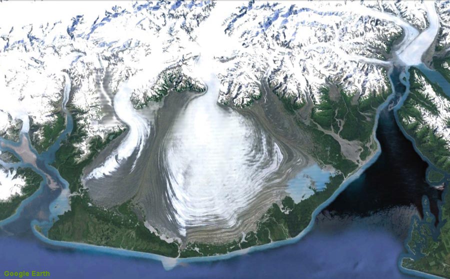 Fig. 13-6. Gulkana Glacier, a piedmont glacier forming from merging valley glacier in Alaska. (Part of Wrangell-Elias National Park). |
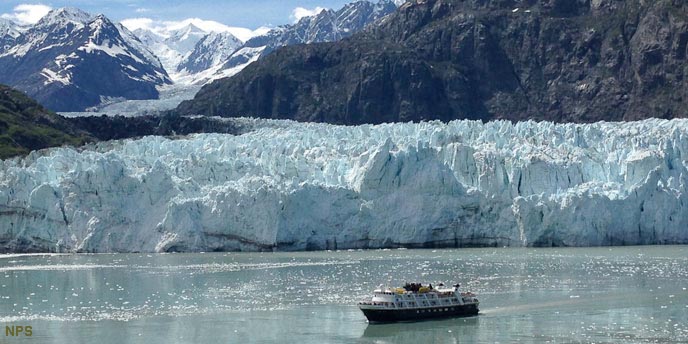 Fig. 13-7. The Grand Pacific Glacier is an example of a tidewater glacier located in Glacier Bay National Park, Alaska. The glacier is constantly calving icebergs and silty sediment into Glacier Bay. |
What Are Ice Ages and Glaciations?An ice age is a period in Earth's history when the global temperatures cooled enough for glaciers (both alpine and continental glaciers) to form. Note that parts of the world (Greenland and Antarctica) are still experiencing ice-age-like conditions.A glaciation is a period when ice or glaciers cover the land's surface. In the not too distant geologic past large continental ice sheets covered large portions of North America and Europe. Figure 13-8 illustrates the extent of the Laurentide ice sheet when it covered much of North America during the peak of the last ice age. Earth has experienced ice ages at least 5 times. Sedimentary rocks preserve evidence of ancient glacier deposits formed around ancient continents, twice in Precambrian time, twice during the Paleozoic Era, and the latest occurring through the Quaternary Period, lasting to the present. Sedimentary rocks show that ice ages are actually cyclic, having cold periods associated glacial advances with intervening warm periods (interglacial periods) when glaciers melt back. The current cycle of ice ages began about 3 million years ago during Pliocene Epoch (an epoch of the late Tertiary Period spanning about 5.3 to 1.8 million years ago). The cycles of ice-age glaciations and intervening warming periods began in Pliocene time. Major glaciation cycles occur many times throughout the following Quaternary Period. The Quaternary Period is subdivided into the Pleistocene Epoch and the Holocene Epoch. The Pleistocene Epoch represents the time span of about 1.8 million to about 11,000 years ago. There were many episodes of continental glaciation and intervening ice-free periods (interglacial periods) occurred within the Pleistocene Epoch. The Holocene Epoch began about 11,000 years ago, about the time that human population growth and distribution expanded worldwide. The current Holocene Epoch is considered an interglacial period, despite glaciers still persisting in Greenland and Antarctica. Wisconsin Glaciation is the name of the last, most recent glaciation period occurred in the geologic time interval about 70,000 to about 10,000 years ago, at the end of the Pleistocene Epoch. During the Wisconsin glaciation massive continental glaciers covered much of North America and northern Europe. These massive ice sheets vanished at the end of the Wisconsin Stage. |
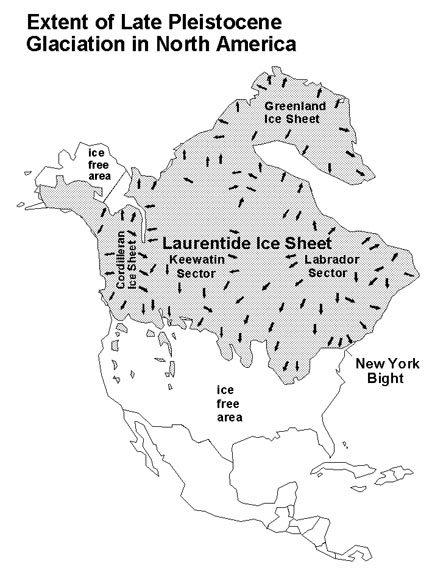 Fig. 13-8. Maximum extent of the Wisconsin Glaciation, the last glaciation cycle during the current ice age. Earth is now within an interglacial warming period called the Holocene Epoch. |
Interpreting Ages of Glacial Periods in North AmericaThe naming of glacial periods has changed over time as more information accumulated about the timing of glaciation and interglacial periods. Difficulties in determining the exact ages of ice ages and interglacial periods is that the data derived on land and from marine sediments are difficult to exactly correlate. Data ice-cores have helped determine the relative temperature of the planet over time (Figure 13-9) Ice-age information is also derived from the detailed studies of marine sediment cores collected throughout the world's oceans. Early glaciation research focused on land-based studies. Much is known about the last two glaciation cycles (the Wisconsin and Illinoian stages) but little was learned about many other earlier glaciation periods because the deposits of the earlier glaciation and interglacial periods are highly degraded, or obscured or destroyed by younger glaciation events throughout North America. The table below summarizes the names and ages of older glacial and interglacial periods. Some of these names have been changed or abandoned as newer data has become available. There may have been as many as 20 glaciation periods during the late Pliocene through the Pleistocene Epochs (during the last 3 million years). Of these, at least 7 major glaciation periods occurred in the last 700,000 years
|
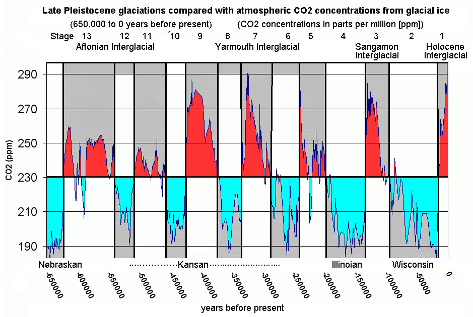 Fig. 13-9. Glaciations of the late Pleistocene Epoch. This diagram shows the relative concentrations of carbon dioxide levels preserved in glacial ice samples. Carbon dioxide levels increase during interglacial periods when the Earth was warmer. |
What Causes Glaciations?The record of the rise and fall in sea level is well preserved in sediments deposited in restricted coastal and marine sediments. Sediments of Pleistocene age are well exposed in many places allowing paleoclimate scientist to evaluate the sedimentary record in many locations (for example, sediment of Late Pleistocene age are well exposed in the sea cliffs at Ft. Funston Beach near San Francisco, CA, Figure 13-10). Some of these glaciation cycles were more intense than others, and they impacted regions around the world differently. Each of the glaciation cycles was followed by an interglacial warming period in which the continental glaciers retreated (or more accurately, melted back). We are currently in one of the interglacial warm periods (although it wouldn't feel like that in Greenland or Antarctica where glaciation is still occurring). The cause of glaciations and interglacial melting periods have been widely debated, but one theory may show that extraterrestrial factors may be involve relating to cycles in Earth's orbit and rotation on its axis.Milankovitch Theory: The Astronomical Connection To Glaciation CyclesEarly in the 20th century, a Serbian geophysicist and astronomer name Milutin Milankovitch worked out mathematically the subtle changes in Earth’s orbital cycles, involving cyclic changes in its rotational axis and its revolution around the Sun changes. Three orbital forcing cycles include the eccentricity of Earth's orbit, Earth's axial precession (41,000 years), precession of equinoxes (21,000 years)(illustrated in Figure 13-11). Eccentricity refers to the change of earth's orbit from being round to more elliptical in shape this cycle repeats every 95,000 years. When it is more elliptical the Earth has shorter, warmer summers and longer, colder winters. Axial precession refers to the wobble in the tilt of Earth's axis. The tilt of the axis changes from about 21.5 to 24.5 degrees on a cycle lasting about 41,000 years. The precession of equinoxes refers to which hemisphere is facing the Sun when it is closest to the Sun. Right now, the Earth is closest to the Sun during the winter in the Northern Hemisphere. These cycles impact how much incoming solar radiation that the regions of the earth receive over time, most important being where land is exposed in high latitude regions (where continental glaciation has taken place repeatedly). Milankovitch showed that these cycles combine or interfere with each other in the amount of energy the polar regions receive through time. Climate investigations in the last century have shown that Milankovitch Cycles do somewhat closely correspond with the record of global temperature changes retrieved from ice cores, marine sediments, and other sources.Milankovitch Cycles alone don't explain the onset of the ice ages. Other large-scale factors may have influenced the global climatic cycles. For instance, during the last several million years, the Himalayan Mountains and Tibetan Plateau have risen, impeding atmospheric circulation in the Northern Hemisphere. In addition, the formation of the Isthmus of Panama (connecting South America to North America) changed the patterns in the circulation of equatorial ocean waters around the globe. In addition, the amount of energy the Sun releases may be cyclic as well. The interactions of global plant cover, global cloud cover (and precipitation), polar sea ice, and impacts of massive volcanic eruptions may all have possible influence on glaciation cycles. |
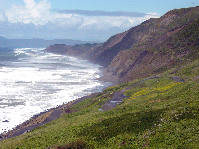 Fig. 13-10. The sedimentary record preserves evidence of numerous glaciation cycles such as exposed in sea cliffs at Ft. Funston Beach, California.  Fig. 13-11. Milankovitch cycles include: a) eccentricity of Earth's orbit around the Sun, b ) axial precession (Earth wobbles on its axis), c) precession of equinoxes (which hemisphere is facing the Sun when Earth is closest to the Sun). |
How Do Glaciers Move?Gravity is the driving force for glacier movement. However, the rate of accumulation and melting of ice are factors that influence glacial activity. Figure 13-12 shows a profile of a simple glacier, showing its motion and impact on erosion of bedrock.The zone of accumulation is the upper part of a glacier where snow accumulation and ice formation takes place faster that it melts, forming the glacier. The zone of ablation is the downslope end of a mountain glacier where melting out paces the accumulation of new ice and snow. (Ablation is the removal of snow and ice by melting or evaporation, typically from a glacier or ice field.) A theoretical line called the snowline is the location on a mountain glacier where the rate of accumulation is equivalent to the rate of melting. Snowline rises and falls with seasons and climate changes from one year to another. When the rate of accumulation increases a supply of ice to a glacier, surging may occur; surging is the sudden movement of a glacier downslope. If ablation is equal to accumulation, then the glacial front stops moving. As glaciers move downslope they may meet resistant obstacles of hard bedrock, or they my encounter a change in slope. These cause changes in ice motion causing fractures to form and open in the ice flow. A crevasse is a deep open crack, especially one in a glacier. Where glaciers meet a body of water (ocean or lake), large blocks of ice will split of fall away from the toe of the glacier. Calving is the process of blocks of ice falling off the face of a parent glacier, ice shelf, or iceberg (Figure 13-13). |
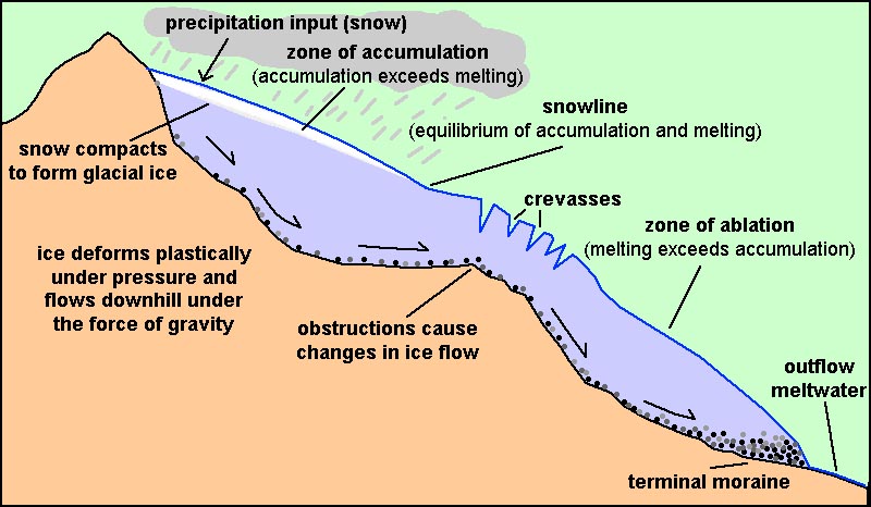 Fig. 13-12. Profile of a glacier 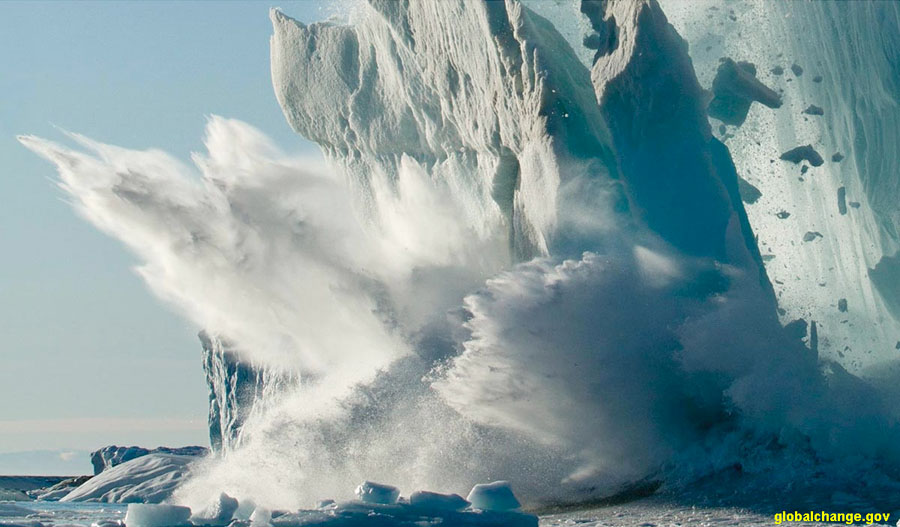 Fig. 13-13. A big slash! Ice calving from the face of a glacier, forming icebergs. |
Cold Climate EnvironmentsHigh Elevation and high latitude regions are colder because the atmosphere is colder. Timberline is the line or altitude above which no trees grow because the annual temperature is too cold. Timberline is about 16,000 at the equator and near sea level north of the Arctic Circle. In the continental United States, timberline ranges roughly between 8,000 and 11,000 feet (Figure 13-14). In southern Alaska, timberline is as low as 2,000 feet. Timberline approaches sea level north of the Arctic Circle.Large regions of the high-latitude, northern and southern polar regions have permafrost, meaning the soil on and near the surface is permanently frozen. The word tundra applies to a vast, flat, treeless Arctic region of Europe, Asia, and North America in which the subsoil is permanently frozen. Mountain regions above timberline also have tundra-like characteristics. |
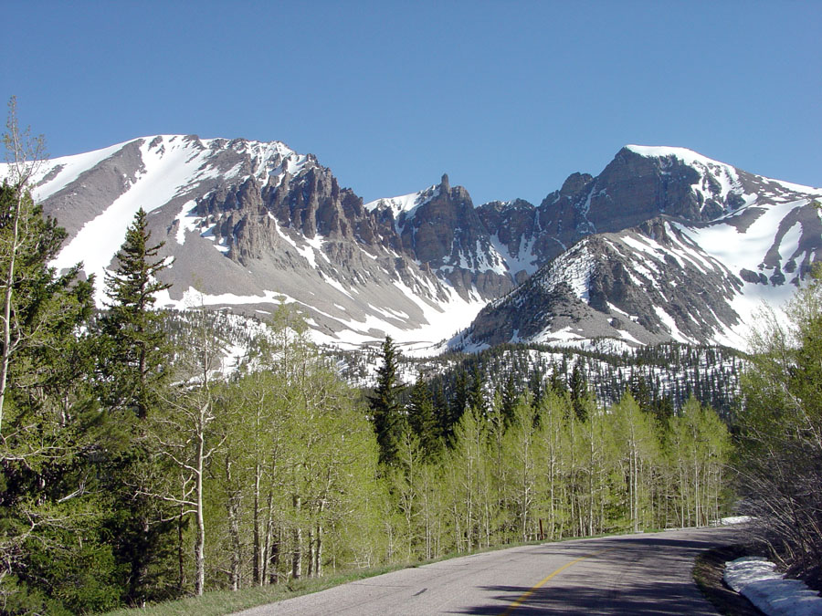 Fig. 13-14. Wheeler Peak (Nevada) rises above timberline (about 9,000 feet). |
Landforms Created By Glacial Activity In Mountainous Regions |
| The effect of glaciation is most obvious in areas where glaciers are currently active. These same landscape feature are still visible in regions that experience glaciation during the Pleistocene Epoch. For instance, Glacier National Park's landscape was heavily sculpted by mountain glaciers, but there is very little ice remaining in the region today. At one time all the valleys in the park were filled with large valley glaciers. Examples of glacial landforms in mountainous regions include: A horn a pointy mountain peak having concave faces carved by glaciation (Figure 13-15 to 13-17). For example, the famous mountain-climbing mountain, the Matterhorn, is a horn in the Switzerland Alps. An arete is a narrow, jagged mountain ridge that divides two cirques or glaciated valleys (Figure 13-15 to 13-17). A col is a saddle in a glacially carved mountain ridge (a gap in an arete). A cirque is a bowl-shaped, steep sided hollow at the head of a valley or on a mountainside, formed by glacial erosion (Figure 13-17). A tarn is the name for a small mountain lake, especially one formed by glaciers; typically found within the basin of a cirque. A hanging valley is a U-shaped canyon (carved by a mountain glacier) that intersects with a larger, deeper U-shaped valley. The mouth of a hanging valley is a typical locations where large waterfalls occur (such as in Yosemite National Park, Figure 13-18). A roche moutonnee is a French name for an elongate mound of bedrock worn smooth and rounded by glacial abrasion, typically with a steep slope of cliff on the downhill side formed by the plucking away of blocks of bedrock by the moving glacial ice (Figure 13-19). Pater noster lakes are a series of moraine-dammed lakes formed by the intermittent retreat of a valley glacier in a mountainous region. A fjord Is a long, narrow, deep inlet of the sea between high cliffs typically formed by submergence of a glaciated U-shaped valley along mountainous coastlines . Many of the inlets along the coast of Norway and Sweden are fjords. The Hudson River Valley is an example of a large fjord in the United States (Figure 13-21). |
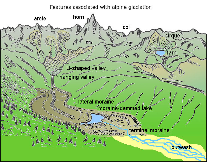 Fig. 13-15. Landscape features associated with alpine glaciation in mountainous regions. 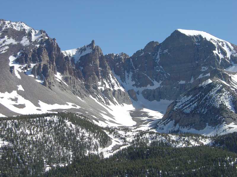 Fig. 13-17. An arete with a large cirque with snow fields in Great Basin National Park, Nevada. Horns and cols dominate the arete (ridge line).  Fig. 13-19. A roche moutonnee in Harriman State Park, New York |
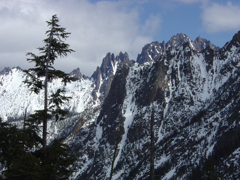 Fig. 13-16. An arete with horns and cols in North Cascades National Park, Washington 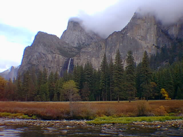 Fig. 13-18. U-shaped valleys (with steep walls) and a hanging valley in Yosemite National Park, CA 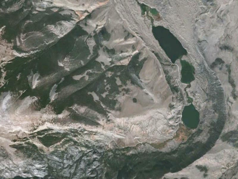 Fig. 13-20. Pater noster lakes in Torrey Canyon, Wind River Mountains, Wyoming |
Erosional and Depositional Features From Past Glaciations |
| Glaciers both scour the bedrock and deposit large quantities of sediment. All kinds of glaciers leave traces when the ice melts. Figure 13-22 shows landforms left behind by a retreating continental glacier. The "toe"region of a continental glacier (where it is melting faster than advancing) is where large amounts of sediments accumulate). Both erosional and depositional features are summarized below: Glacial erosion features include scratch-like features both on rocks or on bedrock and include: Striations are parallel grooves such as: the scratches left by a glacier on rocks (Figure 13-23). Striations reveal the direction that glacial ice moved as rock embedded in the base of the moving glacial ice scrape and erode the bedrock. Glacial grooves are trench-like striations carved in bedrock caused by rock-bearing moving ice at the bottom of a glacier. Grooves can range from small to large striations up to many meters wide (Figure 13-23). Depositional features include both sediment deposits and ice-sculpted landforms: A glacial erratic is a rock or boulder that differs from the surrounding bedrock and is believed to have been transported from a distant location by glacial action (Figure 13-24). Till is the name for unsorted material deposited directly by glacial ice and consisting of rock fragments ranging from large boulders to sand, fine silt, and clay (Figure 13-25). Moraine is the name for accumulations of rocks and sediment deposited by a glacier, typically as ridges at its edges or its terminal boundary of flow and zone of wastage. Moraine deposits are made up of glacial till. A line of hills that defines the furthest extent of a past glaciation cycle is called a terminal moraine. For instance, the low line of hills that run across Long Island, NY are the terminal moraine of the Wisconsin continental glacier. A drumlin is a low oval-shaped mound or small hill, typically one of a group, consisting of compacted glacial till shaped by flowing ice in a region that experienced glaciation. An esker is a long, typically winding, ridge composed of gravel and other sediment deposited by melt water from a retreating glacier or ice sheet. Esker deposits follow the ancient trace of the stream that may have been beneath the surface of the glacier. A kettle is a shallow, sediment-filled body of water formed by retreating glaciers surrounded by glacier deposits (till, outwash, or moraine). Outwash is sediment deposited by streams draining from a melting glacier. Valleys downstream of a melting glacier typically have an outwash plain formed by sediment-choked melt waters depositing sediments along migrating braided-stream channels. Loess is a tan, buff to gray windblown deposit of fine-grained, loamy, calcareous silt or clay; fine-grained deposits typically derived from glacial outwash plains or dust derived from arid regions. |
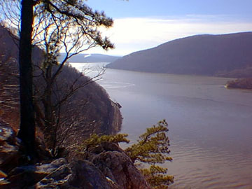 Fig. 13-21. Hudson River fjord at Bear Mountain, New York 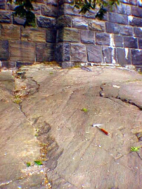 Fig. 13-23. Glacial striations and grooves in bedrock, New York City, New York 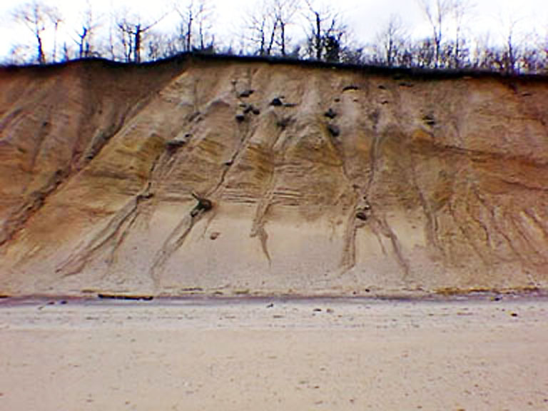 Fig. 13-25. Glacial till and outwash exposed at Caumsett State Park, Long Island, New York |
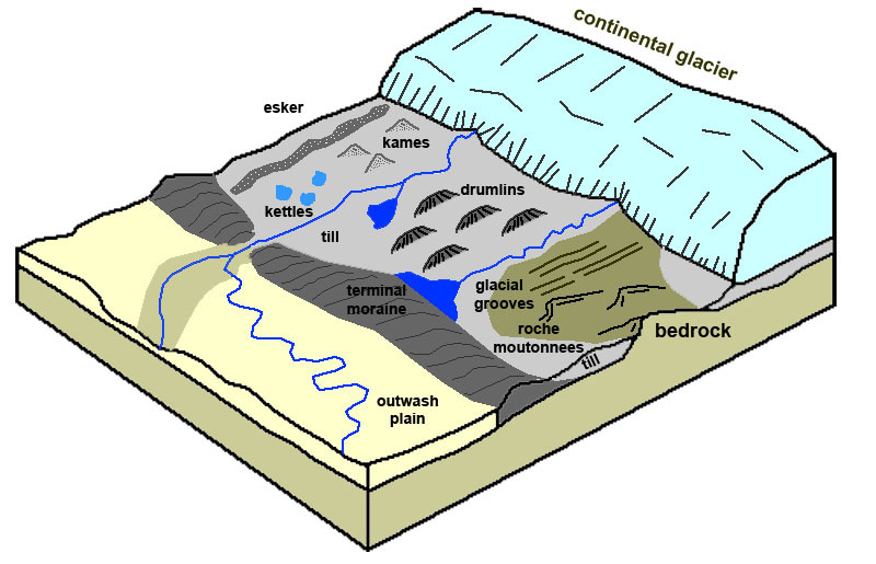 Fig. 13-22. Features associated with continental glaciation deposits. 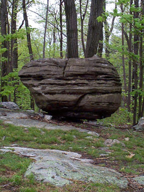 Fig. 13-24. A glacial erratic in Jenny Jump State Park, New Jersey 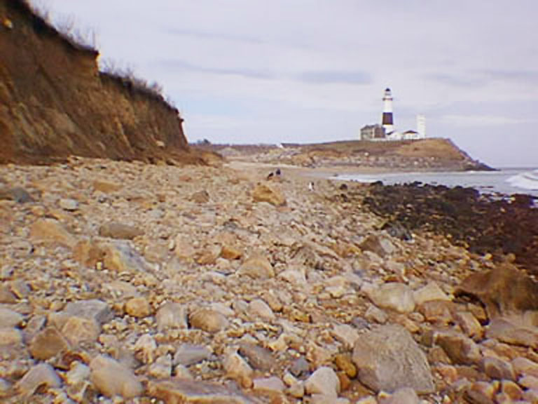 Fig. 13-26. Glacial moraine at Montauk Point is part of the terminal moraine of the Wisconsin-age glacier on Long Island, New York |
Glaciations and Sea Level Changes Through Earth HistoryThe observable effects of sea level changes are preserved everywhere around the world's ocean basins. The study of sedimentary deposits of all geologic ages has revealed that sea level has risen and fallen many times, sometimes in the range of hundreds of meters (Figure 13-27). Some of the most drastic changes in sea level are associated with mass extinctions in Earth's history. The fossil record from locations around the world show that major periods of glaciations occurred in Precambrian time (a period called Snowball Earth between about 2.4 and 2.1 billion years ago, and the Deep Freeze between 850 to 630 million years ago. Another occurred in Late Ordovician to Silurian time about 460 to 430 million years ago, and again during the Carboniferous Periods between 360 to 260 million years ago. The current Ice Ages of the Quaternary Period began about 3 million years ago. Sea levels are currently rising, and have been since the end of the last major ice age of the Pleistocene Epoch ended about 11,000 years ago. |
 Fig. 13-27. Sea level changes through Earth history. |
Glacial Cycles Interpreted From Ice Cores and Ocean SedimentsDrilling programs have collected ice cores from the Antarctic and Greenland ice sheets, and many more cores have been collected from marine sediments from around the world. Using geochemical methods and isotopic dating techniques the history of the chemistry of the oceans and atmosphere, and sea level changes through time are well documented. For instance, ice has tiny bubbles trapped in them that preserve the chemistry of the air and ice at the time it formed. Sea sediments are loaded with many organic and inorganic materials that can be studied and dated. Shell material of foraminifera contain stable isotopes of carbon and other elements that match the chemistry of seawater at the time that they lived. When glaciers form, the water that forms as ice in polar regions is enriched in light isotopes of oxygen and carbon (light isotopes evaporate from seawater faster than heavy isotopes). As a result, sea water at the peak of glaciation cycles are enriched in the heavy isotopes of carbon and oxygen. The ratios of these isotopes are preserved in microfossil shell material. As a result, scientists have been able to clearly reconstruct a sea level curve compared with atmospheric greenhouse gases (Figure 13-28). |
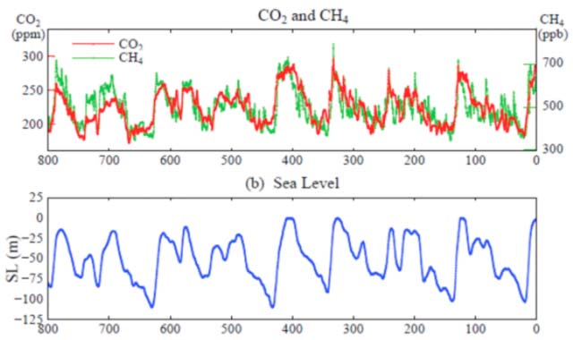 Fig. 13-28. Comparison of concentrations of greenhouse gases with the sea level curve for the last 600,000 years. |
Ice Ages of the Late Pleistocene Epoch Impact On The OceansThe peak of the last glaciation stage (called the Wisconsin Stage) was about 18,000 years ago. At that time large quantities of water that otherwise was in seawater was frozen in continental glaciers (on land) piled many miles thick over large portions of North America and Europe (Figure 13-29). At the peak of the last ice age, glaciers covered about one-third of the land surface. Modern Greenland and Antarctica are a fraction of the volume of these ancient massive ice sheets. With water trapped as ice on land, sea level fell around the world by as much as 400 feet below current sea level, exposing all the regions that are now continental shelves. Current data suggests that there may have been as many as 20 glaciation cycles in the last 2 million years or so. At least 4 of them were major cycles (after about 700,000 years ago). Evidence of these are well preserved in continental glacial sediment deposits (till and moraine) exposed in parts of central North America (even more cycles are recorded in ocean sediments).According to a USGS source, the glaciers currently store about 69% of the world's freshwater (as ice). If all land ice melted the seas would rise about 70 meters (about 230 feet). During the previous warm period (during the Sangamonian interglacial period, about 125,000 years ago), sea level rose about 18 feet (about 6 meters) higher than the current level. Before about three million years ago, before the major continental glaciation cycle began in the Pleistocene Epoch, sea level was as much as 165 higher than today. |
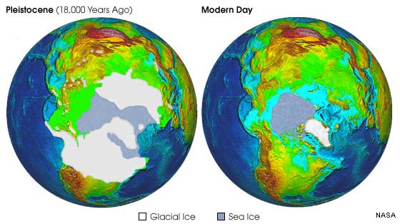 Fig. 13-29. Extent of glaciers and sea ice during the peak of the last ice age and today in the Northern Hemisphere. |
Sea level Changes Caused By Melting Continental Glaciers Since the End Of the Pleistocene |
When continental glaciers form, vast quantities of water migrate from the ocean basins to become ice on land. These continental ice sheets (such on Greenland and Antarctica) can "create their own weather" piling ice up to many thousands to several miles thick in some places. The formation of continental glaciers causes sea level to fall, exposing large regions that are now submerged on the continental shelves. Likewise, when all the ice melts, sea level rises, flooding all the worlds low-lying regions and coastal plains. The Flandrian TransgressionAfter the peak of the last glaciation cycle about 18,000 years ago (the Wisconsin glaciation) sea level has risen about about 400 feet (120 m) (Figure 13-27). The rise in sea level since the end of the end of the last ice age is called the Flandrian Transgression. (The rise in sea level was first recognized in New England and in Belgium in the Flandrian region.) Areas that were coastal plains during the ice ages are now submerged on the continental shelves around the world (Figure 13-28 to 13-30).The rate of sea-level rise slowed down drastically about 3,000 years ago. However sea level is starting to rise again largely due to the impacts of human activity on the global environment. Greenland's ice is melting rapidly. If the world became ice-free (meaning all the ice in Greenland and Antarctica were to melt) sea level would rise as much as 200 feet above it's current level, but hopefully, that won't happen! Sea level has risen about 1 foot in the last century, but the rate is increasing. What does this mean? The extensive rise in sea level had largely erased or hidden perhaps most of the prehistoric knowledge of our species, homo sapiens. For instance, in the United States today, roughly 40% of the population lives in coastal areas (within about 50 miles of the ocean). For the rest of the world, the 40% number also applies. It is easy to assume that in ancient times people liked living near the beach just as much as they do today. This means, that areas that were once habitable on the coastal plain thousands of years ago, are now submerged on the continental shelves. If the trend continues, in the future, the populations that currently live in low-lying coastal regions will also be displaced, and large regions now used for agriculture and wildlife habitat will be submerged under rising sea level (an eventual "Goodbye" to places coastal places currently like South Florida, Houston, etc.!). |
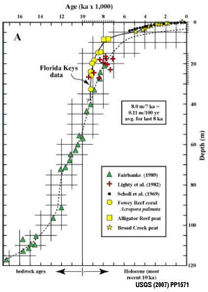 Fig. 13-27. Sea level change following the end of the last glaciation. Sea level has risen as much as 120 meters (400 feet). 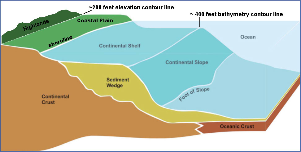 Fig. 13-28. Coastal plain and continental shelf are exposed or submerged with sea level changes. |
World Oceans and Landmasses During the Ice AgesSea level change since the end of the last glaciation has had major impacts on humans and all extant (remaining) species alike. A major mass extinction has been on-going since the last ice age. Many people may argue that it is because of human over-consumption but climate change and sea-level-rise have also been major contributing factors (the two factors are linked). When sea level was low, humans (and other species) were able to migrate throughout the world when what are today's continental shelves were coastal plains (Figure 13-29 and 13-30).At the peak of the last ice age sea level about 400 feet (120 m) lower than today. What are now continental shelves were exposed land (coastal plains) that extended out to near the shelf break around continental landmasses. Rivers and streams carved canyons that have flooded as sea level rose, creating fjords, estuaries and bays we see around the world today. Most of the record of human prehistory is now submerged. |
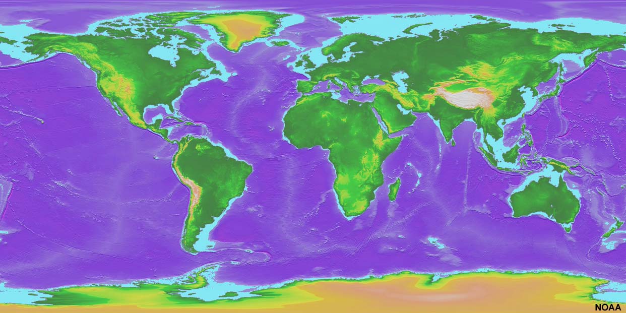 Fig. 13-29. Map of the world with continental shelves shown in light blue. During the peak of the last ice age continental shelves were exposed as extensive coastal plains (allowing humans to migrate). |
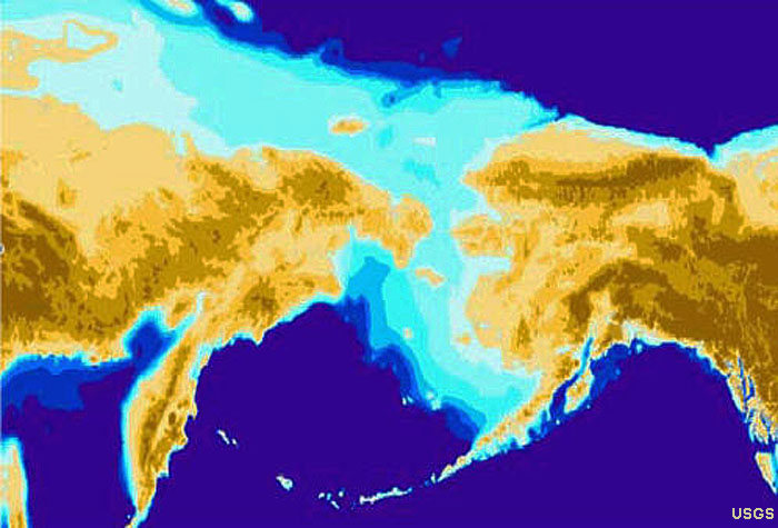 Fig. 13-30. The continental shelf in the Bering Straits region between Siberia and Alaska was exposed during the last ice age, allowing many species (including humans) to migrate between continents. |
Elevated Marine TerracesMany coastlines around the world preserve step-line cliffs and flat surfaces called elevated marine terraces. These features occur along tectonically active coastlines where the shoreline is slowly rising due to geologic uplift over the past several million years. Here is how elevated marine terraces form (Figure 13-31):• As coastlines are rising, sea level is fluctuating up-and-down with the formation and melting of continental glaciers. However, shoreline erosion from wave is constant. • When both the land and sea level is rising together, wave erosion carves a flat surface called a wave-cut bench and a sea cliff. • When sea level falls (as continental glaciers form), the shoreline retreats toward the sea and the wave-cut bench becomes exposed as the land continues to rise. • As the glaciation cycles, sea level begins to rise, but because the land has also risen, wave action begins to carve a new wave-cut bench, and the older wave-cut bench becomes an elevated marine terrace. • Each subsequent glaciation cycle creates a new elevated marine terrace, creating a step-like appearance on hilly or mountain coastlines where the land is rising. Figures 13-32 and 13-33 illustrate examples of marine terraces along California coastlines. California During the Last Ice AgeCalifornia preserves much evidence of geologic, geographic, and climatic changes caused by ice ages (including elevated marine terraces). Figure 13-32 is a map of what California looked like during the peak of the last ice age, about 18,000 years ago. Highlights include:• Alpine glaciers and ice caps covered upland regions in the Sierra Nevada Range and on Cascades volcanoes, but lower elevations were ice free. • The formation of continental glaciers in North America and Europe caused sea level to fall almost 400 feet, causing the California shoreline to migrate seaward as much as 10 to 70 miles westward of the current coastline in some locations. • San Francisco Bay did not exist, instead the area was an ice-free valley a couple hundred feet deeper than the bay is today. All lagoons and bays along the California coastline were exposed valleys at the peak of the last glaciation. • Because of wetter regional climate conditions, large lakes filled many of the inland basins between mountain ranges (they are all dry now except of Mono Lake and Pyramid Lake). Ancient Lake Manly in Death Valley was as much as 800 feet deep. • Regions that are now desert were probably forested and/or grasslands. |
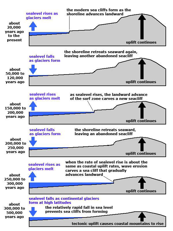 Fig. 13-31. Formation of marine terraces. This example shows the formation of two terraces. At least seven major terrace levels are preserved in some areas along the California coast. 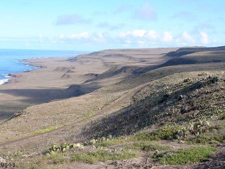 Fig. 13-34. Step-like marine terraces on San Clement Island located offshore in southern California |
 Fig. 13-33. Marine terraces at Davenport, California 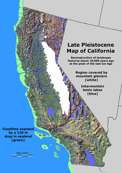 Fig. 13-32. California at the peak of the last ice age. Glaciers covered the higher mountains, lakes filled inland valleys, and a coastal plain was extended offshore. |
Great Lakes in North America (Present & Past)As the great continental glaciers advanced southward out of Canada, they soured the landscape, eroding away soft rock formation under the moving ice. After the glaciers melted scoured areas filled with water forming the Great Lakes in the mid continent region (Figure 13-35) and the Finger Lakes of upstate New York (Figure 13-36). The Pleistocene megafauna of North America included saber-toothed cats, the American lion, elephant-like mammoths and mastodons, giant sloths, short-faced bears, dire wolves, varieties of horses, camels, lamas, bison, moose, musk ox, giant tortoises, giant beaver, giant armadillo, and many other species of mammals and birds that are now extinct. Today, the last remaining large land from the Pleistocene is the American bison. These large animals survived the climate changes of the earlier glaciation periods of the Pleistocene Epoch were all driven to extinction at the close of the last ice age with the arrival and proliferation of our species in the region—Homo sapiens (and the vermin and diseases that followed them). |
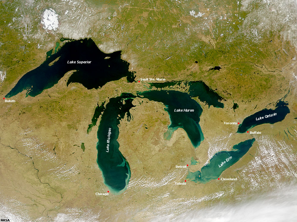 Fig. 13-35. The Great Lakes were carved by the Laurentide Glaciers. 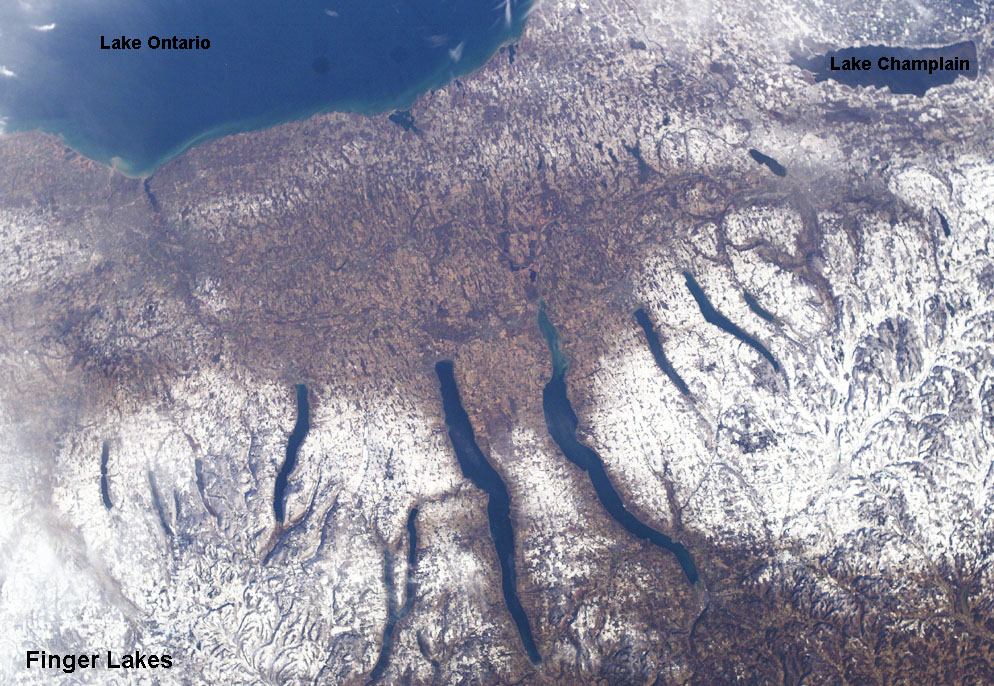 Fig. 13-36. Satellite view of the Finger Lakes, northern New York. |
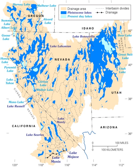 Fig. 13-37. Lakes filled the valleys of the Great Basin during the ice ages. The modern Great Salt Lake of Utah is a tiny remnant of the extensive network of lakes that existed during the peak of the wet glaciation periods. Fig. 13-37. Lakes filled the valleys of the Great Basin during the ice ages. The modern Great Salt Lake of Utah is a tiny remnant of the extensive network of lakes that existed during the peak of the wet glaciation periods. |
Glacial Rebound in North AmericaDuring the last ice age, continental ice sheets grew to many thousands of feet thick, possibly as much as 4-5 miles in the region of Hudson Bay, in northern Canada. The massive loading of ice on the continent forced the continent to isostatically adjust downward to the weight of the ice. With the melting of the ice, the continent is isostatically readjusting back upward, this upward movement of the land in regions that were once under or near glacial ice is called glacial rebound. The region around Hudson Bay, eastern Canada, and southward into Boston and New York City are currently rising due to glacial rebound.Figure 13-38 show that in most places around the coastline of North America sea level is rising because of the melting of continental glaciers. However, in some places sea level is falling. In northeastern North America the land is rising due to glacial rebound (an isostatic adjustment caused by the melting of the great Laurentide continental glacier). In Alaska and other part of the West Coast, tectonic forces are pushing up coastal regions, some of these were rapid adjustments associated with massive earthquakes. |
 Fig. 13-38. Sea level changes around North America. |
Great Floods of the PleistoceneAs great glaciers moved across the landscape the ice and moraine sediments blocked valleys and great lakes (larger than any that exist today) formed along the margins of the advancing ice sheets. When the glaciers started to melt, blocked drainages opened up, and massive floods occurred along with spikes in sea-level rise.Before the continental glaciation cycles began, an ancient large river called the Teays River drained the Midwestern United States (Figure 13-39). It drained across the region of northern Ohio, Indiana, and Illinois before draining into the Mississippi Embayment (near Cairo, Illinois). None of the Great Lakes existed yet. As the glaciers advanced southward, river drainages were blocked, large lakes formed and eventually flooded over into adjacent valleys, forming the regional drainage system that exists today. The modern Ohio and Missouri Rivers basically follow the southern boundary where the continental glaciers ended (Figure 13-40). Ancient Lake Missoula was an glacier-dammed lake that filled, broke out, and flooded portions of the Columbia Plateau several times between 15,000 and 13,000 years ago (near the end of the Wisconsin Stage). The Spokane Floods resulted in the formation of the Channeled Scablands. The Channeled Scablands are a water-scoured network of ancient flood-carved channels that cover large areas in central Washington. The channels are passages of old flow channels essentially barren of soil and regolith (Figure 13-41 and 13-42). |
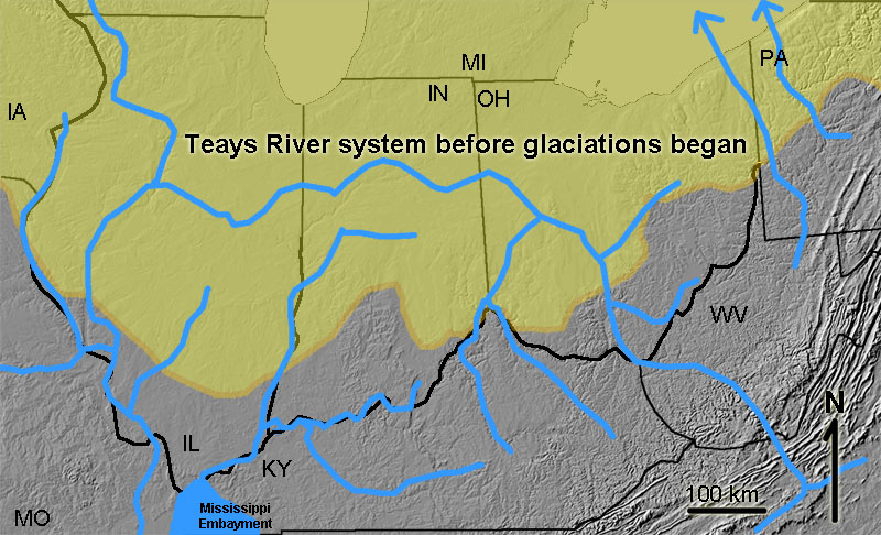 Fig. 13-39. Ancient Teays River system before glaciation began.  Fig. 13-41. The Channeled Scablands of central Washington are areas where soil was stripped away by the massive Spokane Floods. |
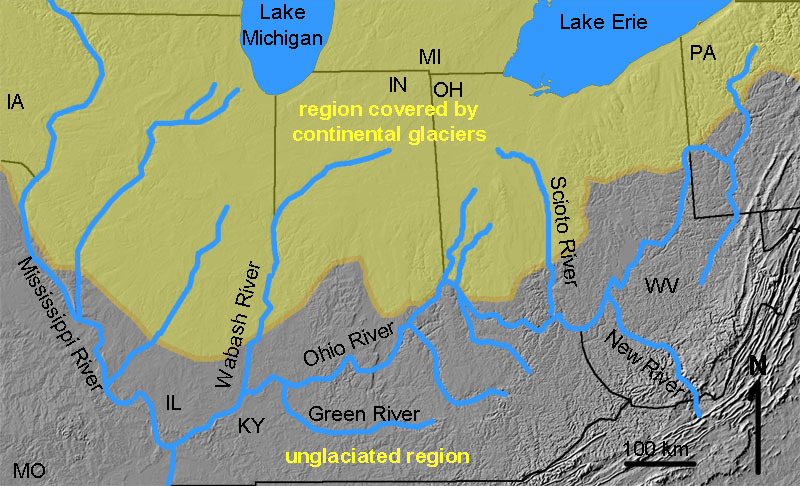 Fig. 13-40. The modern Ohio and Mississippi Rivers system after the Pleistocene. 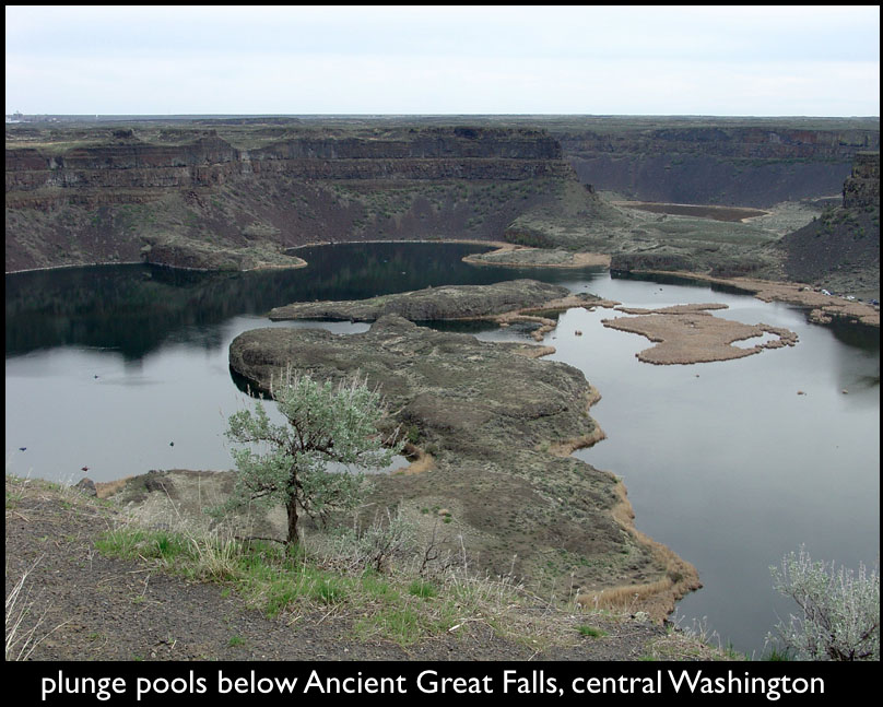 Fig. 13-42. Great Falls, central Washington is an ancient massive waterfall system formed by the Spokane Floods. |
Changing Landscapes of the
|
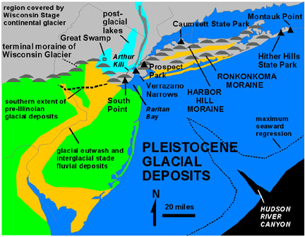 Fig. 13-43. Pleistocene glacial deposits in New York City region |
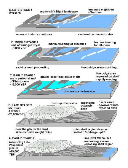 Fig. 13-44. Glaciation and retreat in New York City area |
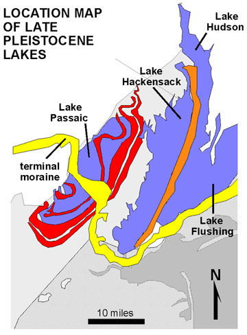 Fig. 13-45. Glacial lakes at the end of the last ice age in New York City |
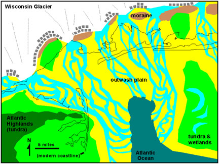 Fig. 13-46. New York City region near the end of the last glaciation |
 Fig. 13-47. Early Holocene landscape in New York City region |
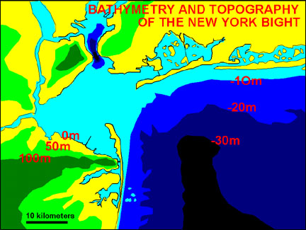 Fig. 13-48. Modern bathymetry and topography of the New York City region |
Increasing CO2 Concentrations in the Atmosphere and Oceans After the Last Ice AgeCO2 concentrations and temperature have tracked closely of the last 300,000 years (Figure 13-49).The recent (if not alarming) increase in CO2 concentrations in the atmosphere is a result of human consumption of fossil fuel, burning forests, and other land use changes. How the Earth's ecosystems are responding to these changes is measurable, and many things are changing. Continental glaciers are melting faster (causing serious concerns about coastal flooding), and the chemistry of ocean water is slowly growing more acidic (endangering ocean species that secrete CaCO3 skeletal material). |
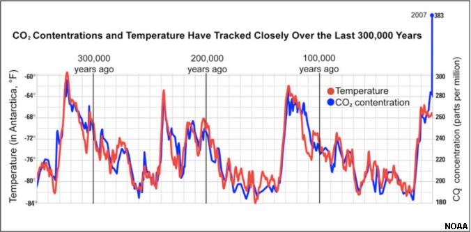 Fig. 13-49. Global temperature and CO2 concentrations over the last 300,000 years. |
Coastal Plains and Evidence Of Past Sea-Level ChangesThe effects of past sea-level changes is very obvious on the landscape. The existence of coastal plains around the world show that sea levels were much higher in the geologic past. Coastal plains are covered with sediments rich in marine fossils, ranging back in time from the Quaternary Period to the Late Cretaceous Period.The Fall LineFigure 13-50 shows a map of the Fall Line. The Fall Line is an imaginary line connecting locations, marked by waterfalls and rapids, where rivers descend abruptly from an upland region to the coastal lowlands. The Fall Line connects are the location where major cities first became established in the American Colonies. Cities developed in these locations because it was the farthest up river ships could travel before unloading. Fall-line cities developed around these historic port locations. In the Eastern U.S. the imaginary fall line is between the uplands of the Appalachian Piedmont and the lowlands of the Atlantic and Gulf coastal plains. The boundary roughly follows an elevation of about 60 meters (200 feet) above current sea level. This elevation was sea level before glacial ice started accumulating on Antarctica about 35 million years ago. At that time the Earth was significantly warmer, and the Atlantic coastal plain was submerged as part of the continental shelf. Since then sea level has risen and fallen many times as continental glaciers have formed and melted. Sea level is now rising, but the increasing rate of that rise is a major problem.Higher Sea Level During the Previous Interglacial Period, 125,000 Years AgoA study presented by the Florida Climate Institute (2012) suggests during the last interglacial period approximately 125,000 years ago sea level peaked between 18 and 30 feet ( 6-10 m) above current sea level. Similar estimates from the study of coastal marine terraces and fossils in exposed coral reefs have been made in the 6 to 10 meter range from around the world. It is important to add that during the last interglacial period that the Earth's average temperature was 1° to 2° C warmer than the present. |
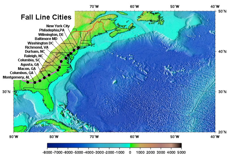 Fig. 13-50. Fall-line cities on along the inland margin of the Atlantic and Gulf coastal plains. |
Projected Estimates For Future Sea Level Rise From Climate ChangeThe Scientific Community has been monitoring the changes of glaciers in Antarctica and Greenland for many decades. Precise measurements in the rate of snow accumulation and melting of glaciers are now made using satellite imaging data (Figure 13-51). Satellite and surface investigation show that parts of the massive Antarctica and Greenland ice sheets are melting, and the rate of that melting is increasing. The greatest amount of melting is occurring along the margin of the glaciers where they enter the ocean along coastlines. Sea cliffs of glacial ice range up to 100 meters high occur along many of these glacier fronts.Increased rate of melting are cause by the collapse of ice along the tidewater zones. Warmer atmospheric temperatures are causing melting on the surface, and warmer water in the ocean is melting the glaciers from underneath. The water melting on the surface of the glaciers is flowing into fractures in the ice sheets (called crevasses). The weight of the water causes hydraulic pressure build up which causes the ice to fracture even more, causing sea cliffs to collapse (resulting in icebergs and sea ice that are moved away by ocean currents). The release of pressure along the glacier front allow the ice to flow under pressure. As a result, glaciers are moving faster from upland glacier sources to the sea. The amount of melting of the continental ice sheets is alarming. The United Nations Intergovernmental Panel on Climate Change (IPCC) has been compiling data from many sources, and has released reports about the projected rate of sea-level rise. The IPCC released a report in 2009 that provided a general estimate that ocean sea levels will rise by and estimated 0.5 to 1 meters by the year 2100, and that some places may see higher or lower sea-level changes base on geographic and oceanographic factors. The Rate of Glacier Melting and Sea Level Rise Is Projected To Increase. The IPCC and other organizations are predicting that if current trends in carbon dioxide and greenhouse gases emissions continue unabated, that the average global atmospheric air temperatures will increase by as much as 4° over the next century (some estimates are higher). The IPCC estimates that the melting of the Antarctic Ice Sheet could cause sea level to rise as much as 1.0 meter (3 feet) by year 2100, 2.6 meters (8.5 feet) by 2150, 5.9 meters (19 feet) by 2200, and 8 meters (26 feet) by 2300. and 15 meters (49 feet) by the year 2500! |
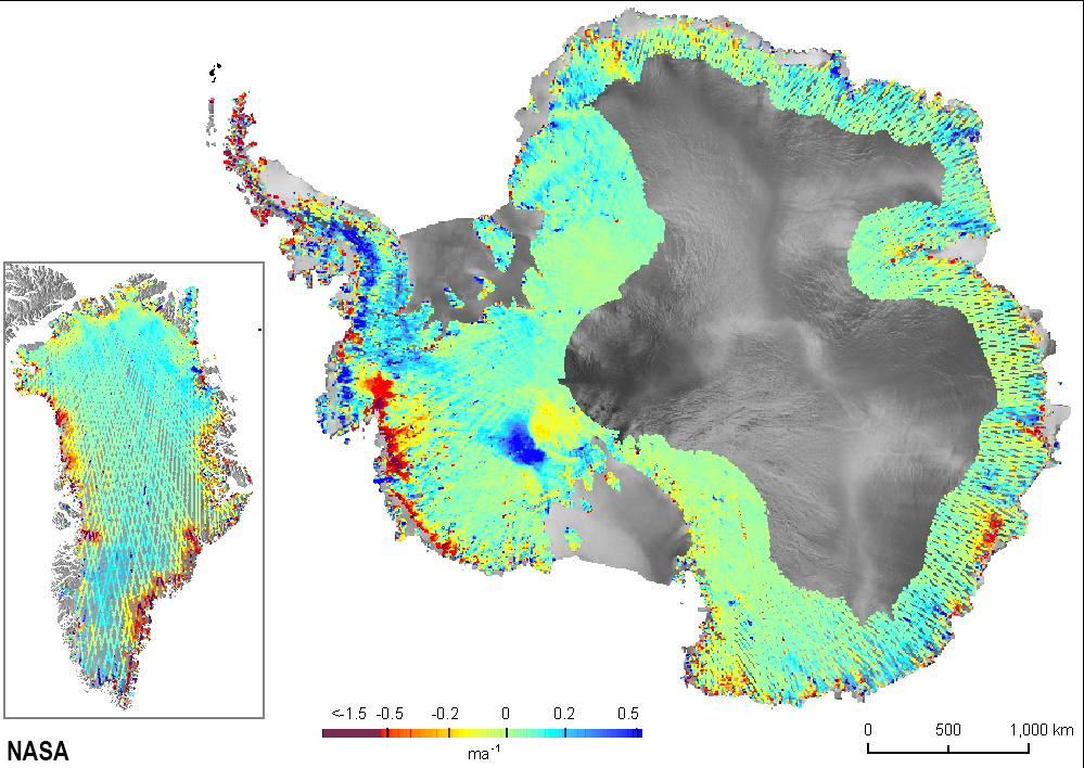 Fig. 13-51. Melting glacier margins in Greenland and Antarctica (satellite data).  Fig. 13-52. Ice cliff along a collapsing glacier front. 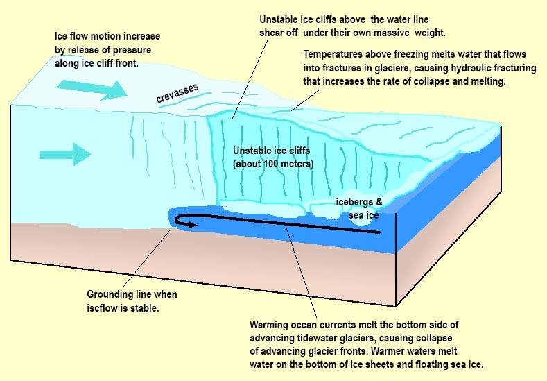 Fig. 13-52. Surface and underwater melting of glaciers. |
Projected Shoreline Changes Based On Future Sea-Level RiseThe effects of climate change and sea-level rise are quite obvious in Louisiana (where the land is sinking and eroding, Figure 13-51).Figure 13-52 shows how the Gulf and Atlantic coastal regions will change with a rise of 1, 2, 3, and 4 meters. It should be noted that nearly all of South Florida and large portions of the regions urbanized coastlines along the Atlantic and Gulf Coasts are below 4 meters in elevation. |
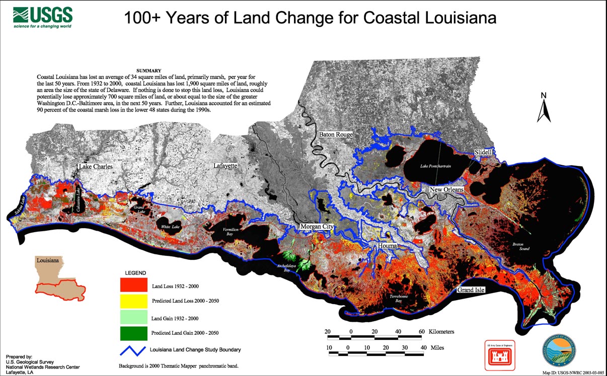 Fig. 13-51. 50 years of land loss from sea level change and coastal erosion in Louisiana. |
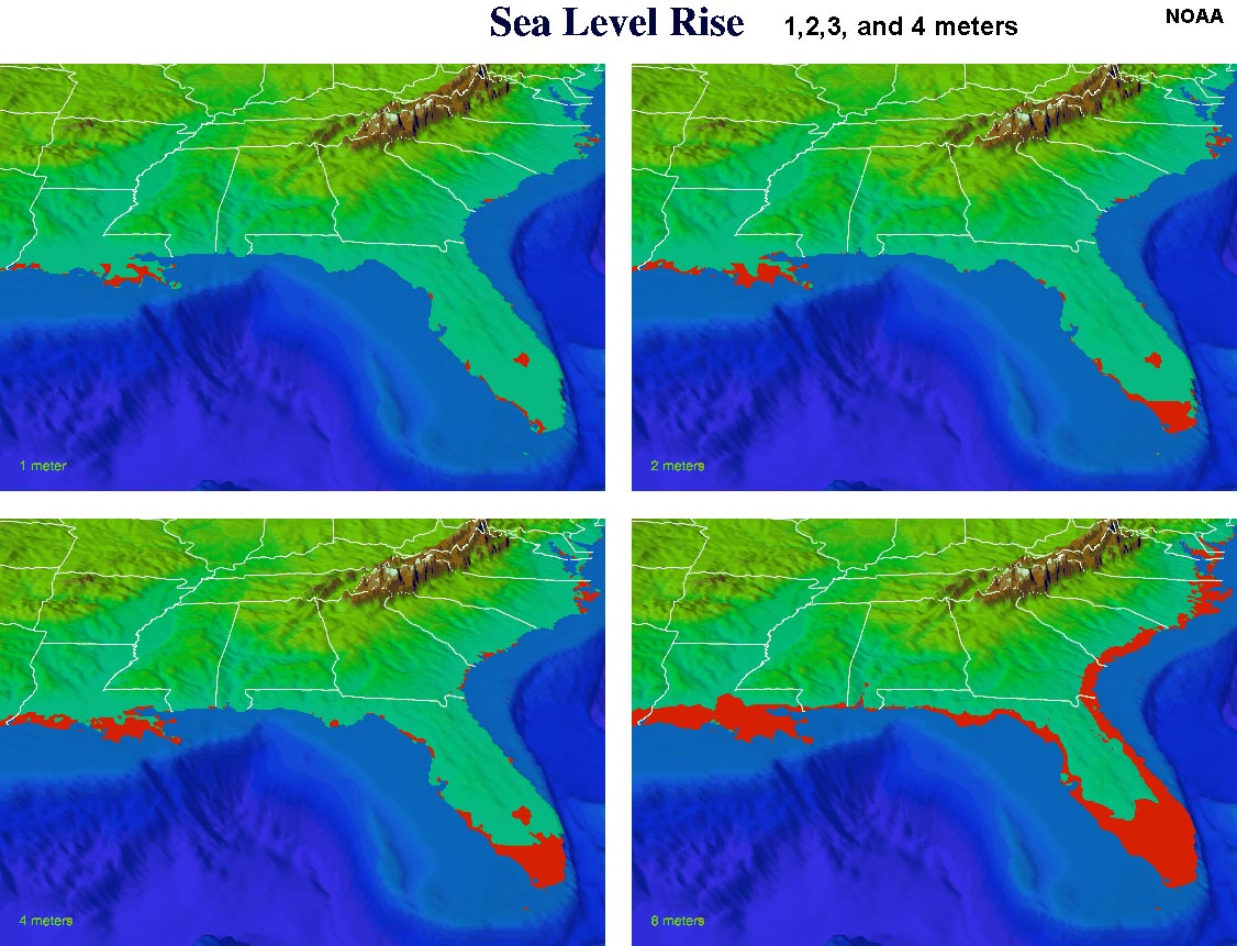 Fig. 13-52. Projected changes from 1, 2, 3, and 4 meters of sea-level rise on the Gulf Coast Region of the United States. |
How Will Civilization Face Climate Change And Sea-Level Rise?Sea level changes caused by the melting of continental glaciers (Antarctica and Greenland) are some of the gravest concerns to scientists studying global warming. Why we know that sea level is changing because vast amounts of data are now available. The debate about estimates on how fast and how high sea level will rise is quite contentious. The political and economic implications are enormous. Some of the most populated locations on the planet are within a few meters of sea level, and this includes both some of the wealthiest and poorest nations.Figure 13-53 shows the 4 meter water line in Washington DC. It will be interesting to see how the political world will deal with these changes as the swamp gets deeper! |
 Fig. 13-53. Projected flood zone of Washington DC if sea level rises 4 meters. |
| Glossary of Glacier Terminology: A glossary providing the vocabulary necessary to understand the modern glacier environment. http://pubs.usgs.gov/of/2004/1216 |
| Chapter 13 Quiz Questions |