
Oceanography 101 |
Return to class home page |
Chapter 4 - Plate Tectonics |
| This chapter reviews the major concepts of Plate Tectonics Theory. Concepts of plate tectonics evolved as questions about the "structure of the Earth" and the age of the ocean basins were resolved over time (discussed in Chapter 3). Plate tectonics is a fundamental theory that captures the science of how the earth works: why "things" are where they are, how they formed, and how they evolved, over time, to become features within the world that we see today. The appearance of the world as we see it today is a result of the accumulative effects of all geologic processes that have happened in the past. Some of these processes occur rapidly (such as volcanic eruptions, earthquakes, great storms and flood, and occasional asteroid impacts). However, most features we see on the landscape or in a region (or larger features like continents mappable on a global scale) involve processes that are far grander, operating both near and deep below the surface, and taking place gradually over long periods of time (in periods measured in millions to hundreds-of-millions of years). For instance, the coast lines of northwest Africa and the eastern United States are currently moving apart at a rate of about 2-4 inches a year. However, about 200 million years ago the two continents were joined together before the opening and formation of the Atlantic Ocean Basin! Plate tectonics theory helps explain most of the processes and grand landscape features we observe around the world today, both on land and beneath the oceans. |
Click on small images for a larger view throughout this website. |
 |
|
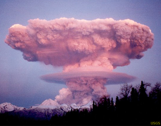
| Fig. 4-1. Nearly all geologic processes observed on Earth "fit" in some way into "Plate Tectonics Theory." |
|
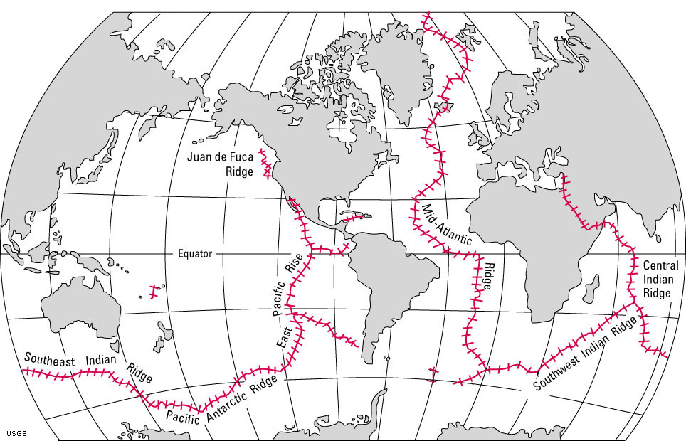
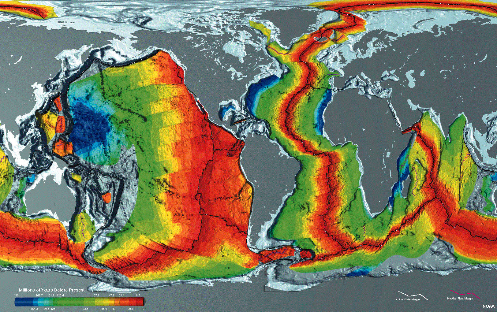
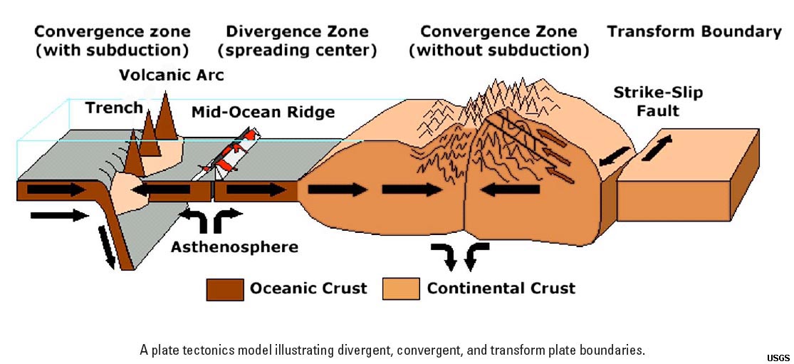
Plate Tectonics TheoryToday, Plate Tectonics Theory explains the large-scale motions of Earth's lithosphere. Plate tectonics theory builds on concepts of "continental drift." It was the global efforts of seafloor exploration following World War II resulted in the development of seafloor spreading theories in the late 1950s and early 1960s. This exploration effort involved perhaps many thousands of scientists within the "global geoscience community" (geologists, oceanographers, paleontologists, and geophysicists, assisted by world leaders) who systematically gathered information and mapped the world, both on land and underwater. The mechanics of Plate Tectonics Theory were largely resolved as large quantities of data about the age and distribution of rocks beneath the ocean basins were compiled from ocean drilling programs and geophysical studies of the ocean crust from around the world. Seafloor mapping, along with the study of volcanoes and earthquakes provided the evidence to support plate tectonics theory.Plate Tectonics Theory helps to explains to some degree almost "all things geological" in the observable world, past and present. Plate tectonics expounds that Earth’s outer shell (lithosphere) is composed of several large, thin, relatively rigid “plates” that move relative to one another. Movements along fault systems that define Lithospheric plate boundaries produce most observed earthquakes. |
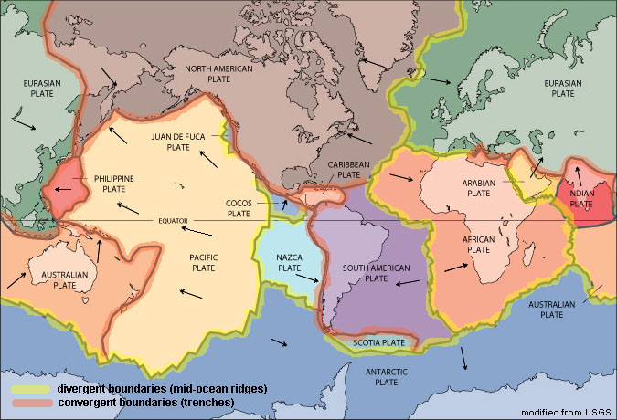 Fig. 4-6. Map showing the location of lithospheric plates and plate boundaries of the world. Boundaries shown in yellow are divergent boundaries, Those in orange are convergent boundaries. Note that some plates include both continental and oceanic crust. |
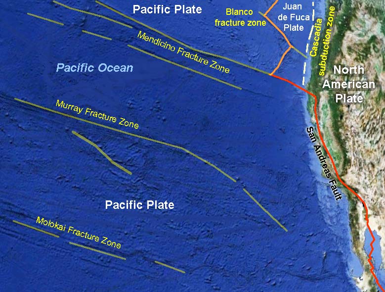
Three Types of Lithospheric Plate Boundaries (see Figures 4-4 to 4-6)Divergent boundary (where plates are pulled apart by tensional forces)—When plates diverge, spreading centers form creating new oceanic crust. Examples include mid-ocean ridges in world's ocean basins. Spreading centers occur where continents are pulling apart. Examples include the Africa rift zones, Red Sea basin, Iceland, and North America's Great Basin region including the Gulf of California (see discussions below).Convergent boundary (where plates are pushed together by compressional forces)—When lithospheric plates collide... mountains belts form - examples include the Himalayas, Alps, and ancient Appalachian Mountains when the ancient continent of Pangaea formed. When continents collide with ocean crust... subduction zones with deep ocean trenches and volcanic arcs form - examples include the Andes Mountains, Aleutian Islands, Japan, Philippines, Indonesia, the ancient Sierra Nevada and modern Cascades Range in northern California, Oregon, and Washington. Transform boundary (where plates slide past or are rotational)—When plates slide past each other creating fault systems along plate margins. Examples include the San Andreas Fault in California and major faults in Pakistan, Turkey, and along the Jordan River/Dead Sea. |
Divergent Plate BoundariesDivergent plate boundaries are locations where tensional forces are pulling things apart. In locations where lithospheric plates are diverging, the rates of divergent motion range from 2 to 17 cm/year.Spreading Centers along Divergent Plate Boundaries
|
 |
 |
|
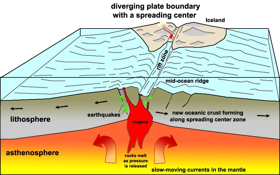
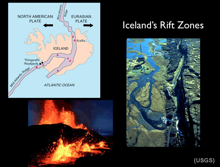
| Fig. 4-7. Formation of new oceanic crust along a spreading center associated with a mid-ocean ridge. Some spreading centers appear on land. For example, a portion of the Mid-Atlantic Ridge is exposed on Iceland. | Fig. 4-8. Iceland's is an exposed portion of the North Atlantic spreading center. Iceland is splitting along a rift zone where new crust is forming. Of 130 volcanoes on the landmass, 30 are currently considered active. |
Seafloor spreading and formation of new ocean crustSeafloor spreading features and processes include:• Involves oceanic crust (OC) only. • Tensional forces pull oceanic crust apart (forming faults that split deep into the newly forming ocean crust). • This forms a mid-oceanic ridge (MOR). • Volcanic activity along faults and fracture zones allows magma to rise cool on or near the seafloor surface. • This volcanic activity generates new seafloor/oceanic crust, • New oceanic crust moves away from spreading center as more is formed. • Youngest oceanic crust is found near the ridge, oldest (and colder)crust is far away from ridge. • Uplifts occurs as it is rifted, so MORs are the shallowest part of deep ocean basins. • The MOR is symmetrical about the ridge. • Magnetic reversals preserved in volcanic rocks are found along MORs worldwide. • Sediments thicken away from the ridge (discussed in Marine Sediments chapter).• Hydrothermal vents (i.e.: vents of hot water called "black smokers") are found in spreading centers. Ocean Rises vs. RidgesSpreading center are active at different rates, resulting in different physical characteristics.A rise spreads faster and is less steep, a ridge is steeper and spreads slower. Examples: • East Pacific Rise (see Figures 4-2, 4-3, 4-6, and 4-9) • Mid-Atlantic Ridge (see Figures 4-2, 4-3, 4-6, and 4-7) • On Iceland, the MOR rises to the land surface, its rate of spreading is about 15 cm/yr (Figure 4-8). |
 Fig. 4-9. The East Pacific Rise is a rapidly forming spreading center (a mid-oceanic ridge that separates the Pacific Plate to the west from (north to south) the North American Plate, the Rivera Plate, the Cocos Plate, the Nazca Plate, and the Antarctic Plate. See Figure 4-6. |
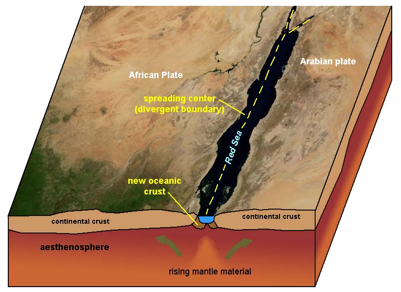
Continental RiftingContinental Rifting occurs where divergent boundaries form within continental landmasses:• Involves rifting (pulling apart) of continental crust (CC) only. • Forms possibly from convection in the asthenosphere • Large amounts of sediments are usually produced in continental rifting zones. • Initially, when a continental rift forms it has continental processes such as the formation of large lakes, rivers, and beaches. Later, as it pulls farther apart it can become an oceanic rift when sea water floods in. It then becomes a MOR. Present continental rifts include: • Red Sea and East African Rift System (Figure 4-10 and 4-11). * The breakup of Pangaea began with continental rifting starting about 200 million years ago with Africa pulling apart from North and South America. It eventually flooded with seawater and became the new Atlantic Ocean Basin. |
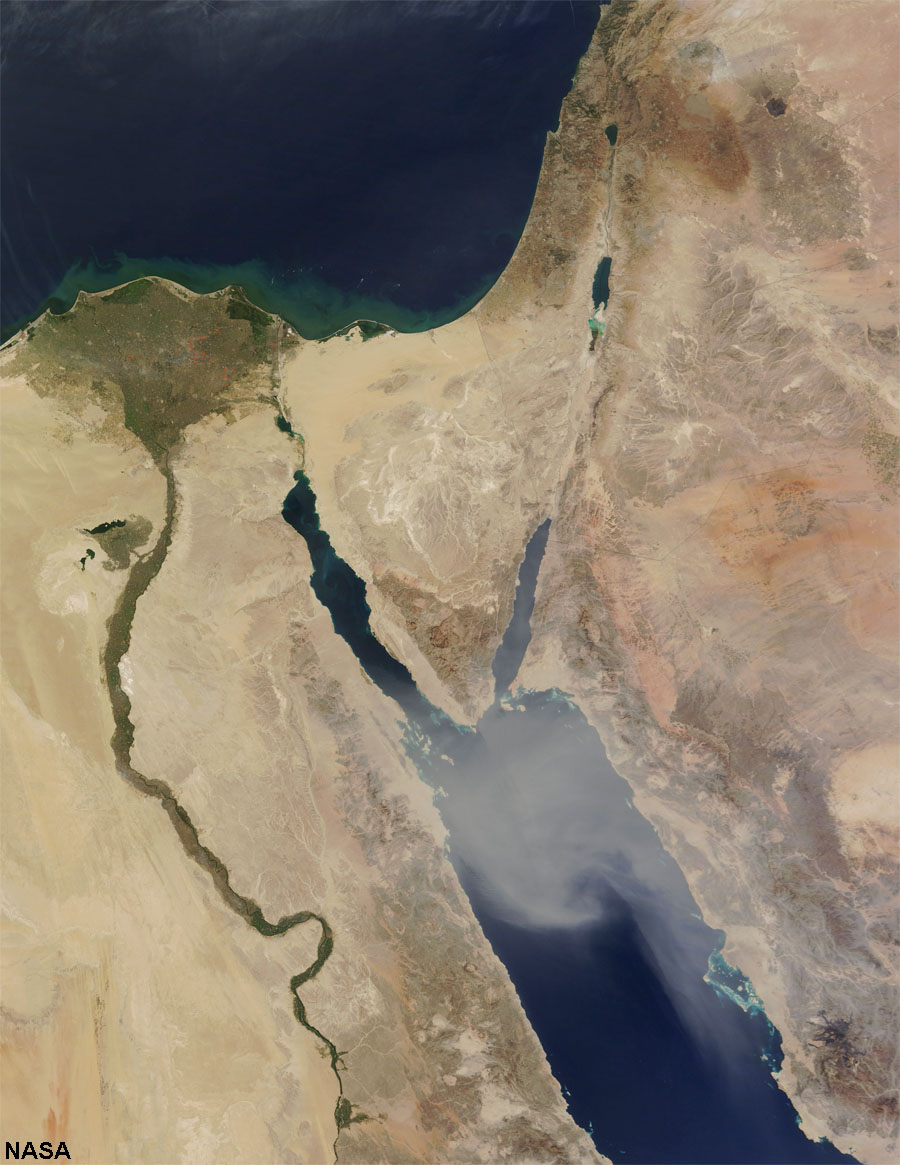 Fig. 4-10. Continental rifts along the Red Sea and Sinai Peninsula (Jordan River, Dead Sea) |
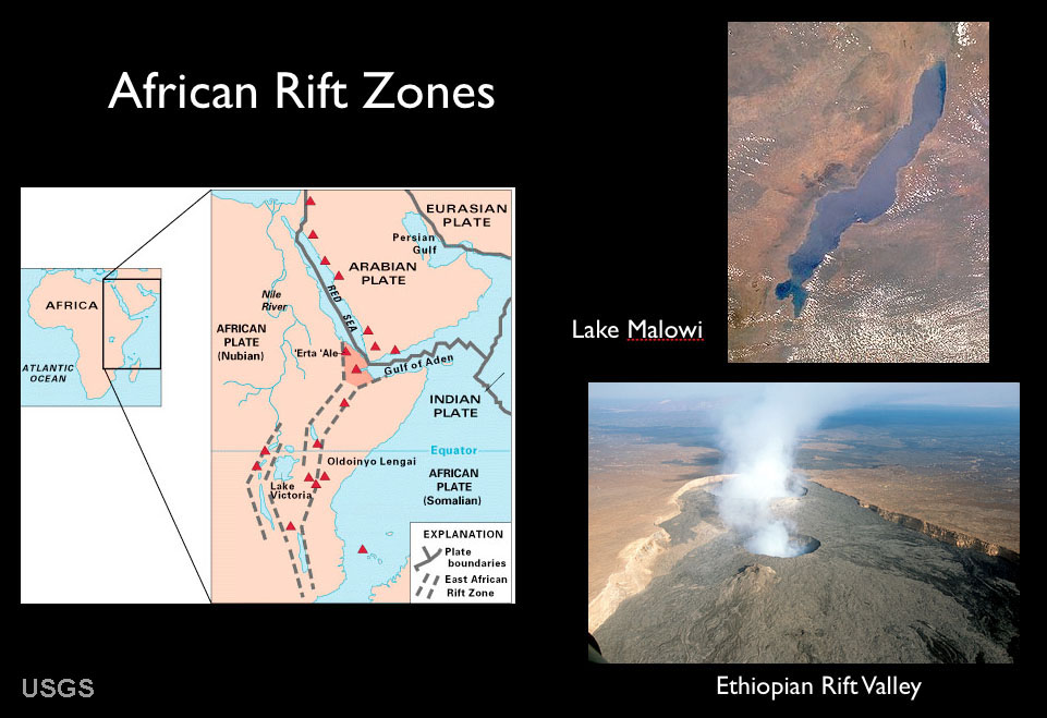 |
| Fig. 4-41. Africa rift zones are zones where the African continent are being pulled apart. The African Rift basins are spreading centers that are the location of large inland lakes and much volcanic activity. One day in the distant future become seas like the modern Red Sea. |
Crustal Extension and Continental RiftingCrustal extension occurs where a divergent plate boundary develops under a continental landmass on a large scale, associated with continental rifting (Figure 4-12).Both crustal extension and continental rifting are occurring in northern Gulf of California and throughout North America's Great Basin region under Nevada, Arizona and eastward into the Rio Grand River rift valley in New Mexico (Figure 4-13). As the Atlantic Ocean opened, the North American continent was pushed over a spreading center that is now the entire region of Utah, Nevada, Arizona, and parts of New Mexico. Baja California and the Peninsular Ranges of San Diego and Orange counties have been rifted away from the Mexican coastline gradually over about 23 million years. Baja will continue moving northward, eventually crushing into southern Alaska in the distant future! |
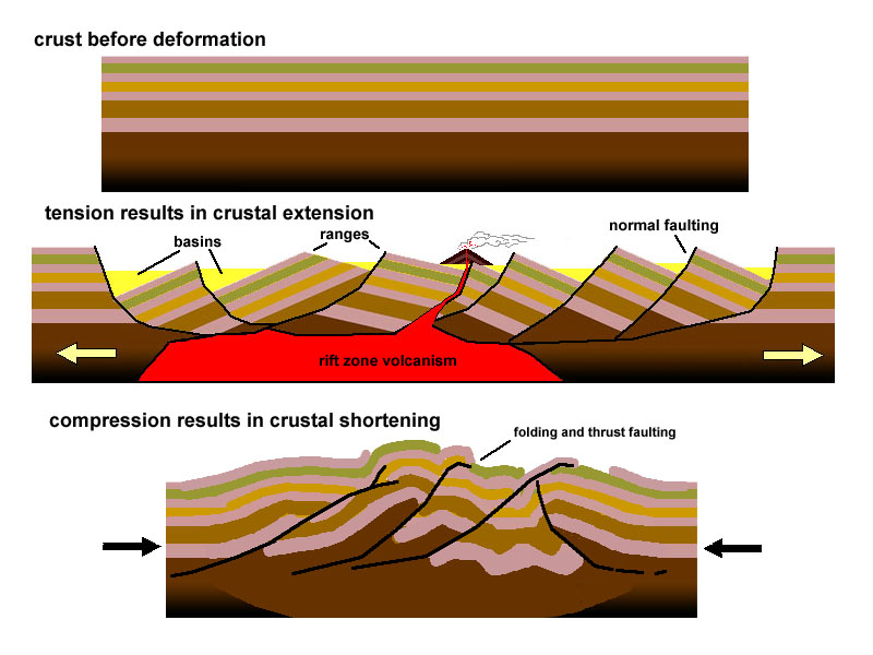 Fig. 4-12. Crustal extension and crustal compression. |
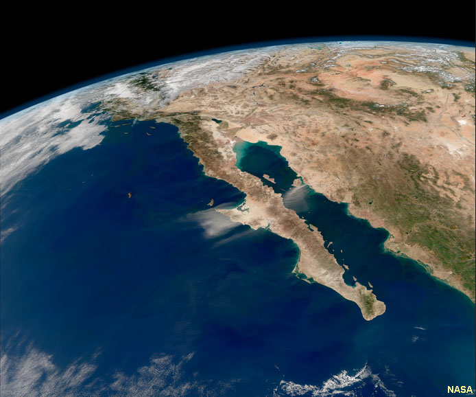 Fig. 4-13. Gulf of California and Great Basin—a region where crustal extension is occurring. |
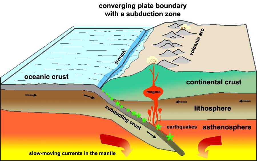
Convergent Plate BoundariesConvergent Plates move together and collide so you have compressional forces. They are associated with active margins—locations where mountain building is occurring, resulting in numerous earthquakes and andesite (explosive) volcanoes.
Figure 4-14 illustrates how earthquake data reveals the geometry of a subduction zone. This diagram show the location and intensity of earthquakes over a period of time in the vicinity of the Tonga Islands in the South Pacific Ocean. A deep ocean trench runs along the southeast side of the island chain. Earthquake data shows that a major fault system descends at an angle, extending eastward beneath the Tonga Island and extends of hundreds of kilometers at a steep angle deep into the upper mantle (asthenosphere) where it is presumed that earthquakes cease because rocks are too hot and under intense pressure that it easier for them to fold and flow plastically than to fracture as brittle rock. The earthquake data suggests that the eastern edge of the Australian Plate is being over run by the western edge of the Pacific Plate, and that rocks of the Australian Plate are descending into the upper mantle. |
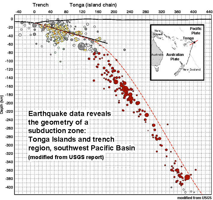 Fig. 4-14. Earthquake data reveals the geometry of a subduction zone in the region of Tonga. |
|
Three types of Convergent Plate Boundaries: OC/CC, OC/OC, & CC/CCThree types of convergent plate boundaries are recognized: .a) Subduction of ocean crust (OC) beneath continental crust (CC) b) Subduction of ocean crust (OC) beneath ocean crust (OC) c) Continental Collisions: continental crust (CC) colliding with continental crust (CC). |
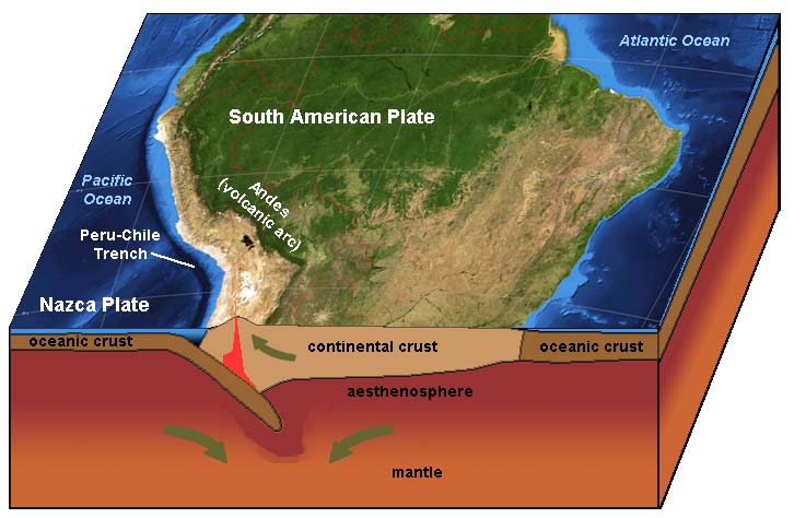
a) Subduction of ocean crust (OC) beneath continental crust (CC).• Denser, thinner OC is pushed or subducted beneath less dense and more buoyant CC.• A chain of volcanoes formed, called a continental volcanic arc. • Subduction produces both deep and shallow focus earthquakes (with tsunami potential); the largest ever--9.5 magnitude in Peru/Chile Trench in 1960. • Volcanoes of the andesite (explosive) type. Examples include the Andes and the Cascade Range , etc. • Deep trenches form around continents margins. Trenches are especially well developed in regions far away from spreading centers (where the ocean crust is old, cold, and denser, and therefore sinks more rapidly). • Subduction reduces amount of (and destroys) OC. • Rates of subduction are up to 15 cm/yr in the active margins of the Pacific Basin. Examples: • Andes in South America (Figure4-15) • Cascades in United States (include such volcanoes as Mt. St. Helens, Mt. Rainier, Mount Shasta, Crater Lake and many others) |
 |
| Fig. 4-15. Subduction zone geometry (OC/CC) is revealed by the location of earthquakes and volcanic activity. Subduction zones are where oceanic crust is destroyed and new continental crust forms. Subduction zones associated with ocean trenches surround much of the Pacific Ocean Basin. |
b) Subduction of ocean crust (OC) beneath ocean crust (OC).• Many similar features as above [OC/CC].• Denser, older, cooler OC is pushed or subducted beneath less dense, warmer, younger OC. • Forms island volcanic arcs. • Deep and shallow (tsunami potential) focus earthquakes • Volcanoes not as explosive as above with OC/CC, as there is no mixing of CC rocks (called granites). Volcanic rocks are mostly basaltic in composition. • Subduction reduces amount of (destroys) OC. Examples: •Japan, Tonga Islands, and Aleutian Islands (Alaska)(Figures 4-16 and 4-17) |
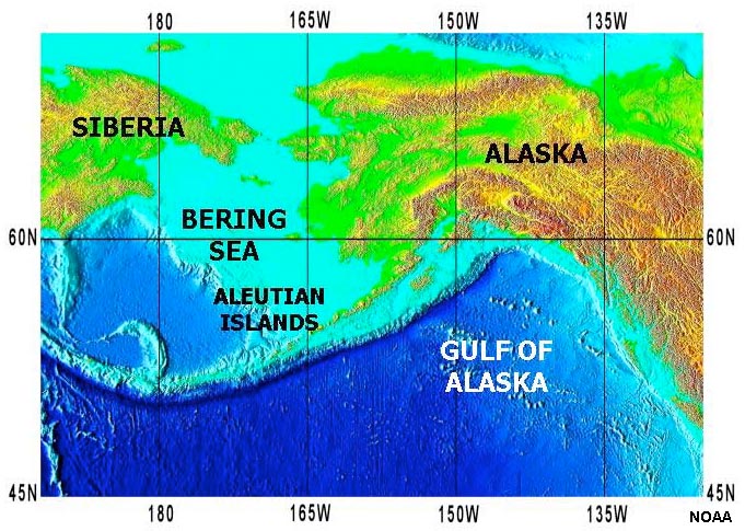 Fig. 4-16. Aleutian Islands and Aleutian Trench. |
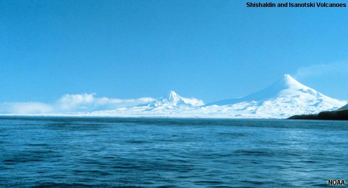 Fig. 4-17. Volcanoes of the Aleutian Islands arc. |
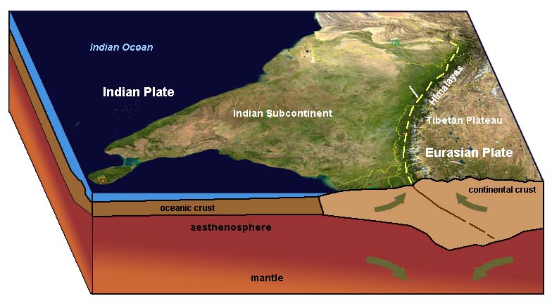
c) Continental Collisions: continental crust (CC) colliding with continental crust (CC)When continents collide with other continental landmasses:• Neither of the CC are subducted, • Both are very buoyant and want to "float" or ride high. • This is where you form the very large mountain chains. • Mountain building occurs with lots of earthquakes; massive erosion also occurs. Examples • Himalayas (India) beginning 45 million years ago) (Figure 4-18) • Alps Mountains are being pushed up by collisions between Africa (and Italian Peninsula) with Europe. • Appalachians Mountains in the eastern United States (formed when North America collided with Africa about 350-400 million years ago (before the Atlantic Ocean opened later). |
 Fig. 4-18. Migration of "India" away from ancient Pangaea has led to the collision of continental land masses resulting in the rise of the Himalayan Mountains. In this region, the continental crust on both sides of the plate boundary are too light to sink into the mantle. |
Review: Examples of Plate Boundaries |
||
| Convergent boundaries | Divergent boundaries | Transform boundaries |
When continents collide mountains belts form. Examples:
|
When plates diverge, spreading centers form creating new oceanic crust. Examples:
|
When plates slide past each other creating fault systems along plate margins. Examples:
|
 |
 |
 |
| Fig. 4-20. Himalayan Mountains are a convergent plate boundary | Fig. 4-21. Mid Ocean Ridge in Iceland is a divergent plate boundary | Fig 4-22. San Andreas Fault system is a transform plate boundary |
| When continents collide with ocean crust trenches with subduction zones and volcanic arcs form - examples:
|
Spreading centers occur where continents are pulling apart. Examples:
|
Transform faults also occur within plates, but are related to movements that shape the seafloor. Examples:
|
 |
 |
 |
| Fig. 4-23. Convergent boundary along the west coast of South America | Fig. 4-24. A divergent boundary forming in the Red Sea area | Fig. 4-25. Transform fracture zones offshore of California are within the Pacific Plate |
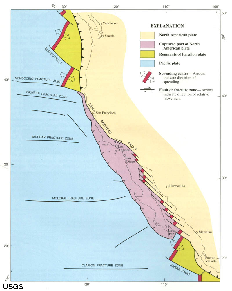
Important! Continental margins may or may not be plate boundaries! For example, the East Coast is in the middle of the North American Plate. Why? When North America first split away from Africa and Europe, there was first a continental rift valley; it became a plate boundary between the three expanding lithospheric plates. As new crust formed along the Mid Ocean Ridge spreading center, it became attached to the plates on either side. Today the North American Continent is part of the larger North American Plate! (See Figure 7-29.) |
||
Hotspots and Mantle PlumesA hotspot is a place in the upper mantle of the Earth at which extremely hot magma from the lower mantle upwells to melt through the crust usually in the interior of a tectonic plate to form a volcanic feature.• These are hotspots beneath the lithosphere caused by rising plumes of hot mantle material. • Can form volcanoes on surface (examples include Hawaii and Yellowstone hotspots (Figures 4-26 and 4-27). -Volcanoes are mostly mafic (basaltic) as these lavas are very hot and very fluid from deep sources. -Less common are felsic (rhyolitic) magmas as they are thicker and less prone to flow. • Hotspots can occur beneath any crustal type (OC or CC). • Where they form a trace consisting of a chain of volcanoes (like in Hawaii's Emperor Seamount Chain, Figure 4-26) • Hotspots can exist in about the same place for 10's of millions of years • The Hawaiian Hotspot has existed for about 60 million years; the youngest part of the Emperor Seamount Chain. • The oldest part of the Emperor Seamount Chain has already been subducted (destroyed). • There are hundred of hotspots located around the world. Some are larger and more active than others. • Most hotspots are located under the interior sections of lithospheric plates, but some occur near divergent plate boundaries. • Paleomagnetism in rocks on the ocean floor associated with hotspots provides a method for determining speed and direction of plate motions. • We are not sure of the exact mechanism that forms hotspots, there are some ideas (see below). Yellowstone National Park Hotspot:• The Yellowstone hotspot currently under continental crust (Figure 7-50).• Yellowstone is a very large and complex supervolcano. The Yellowstone supervolcano is at the eastern end of a long chain of progressively older supervolcanoes that formed along the trace of the Snake River Plain (Idaho, Washington, and Oregon) • The hotspot had formed volcanoes of both basaltic and rhyolitic composition. • Has had large rhyolitic eruptions 3 times in the last 2 million years • This hotspot appears to have been present for less time than the Hawaiian hotspot (about 17 million years). |
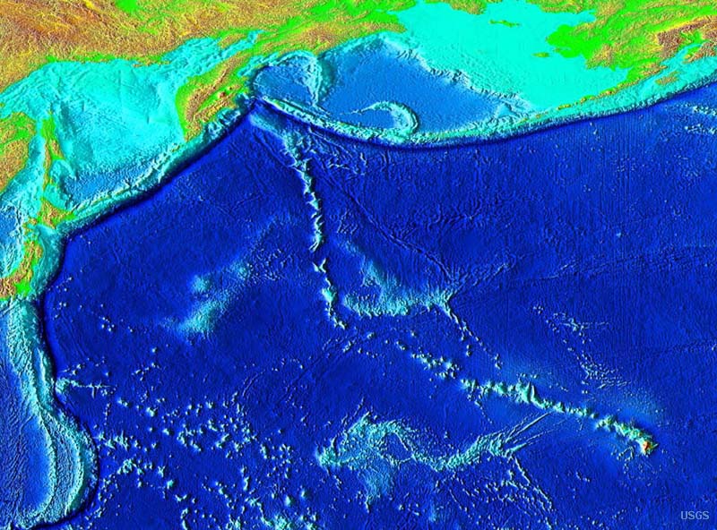 Fig. 4-26. Map of the Hawaiian Hotspot and the Emperor Seamount Chain in the Pacific Ocean basin. 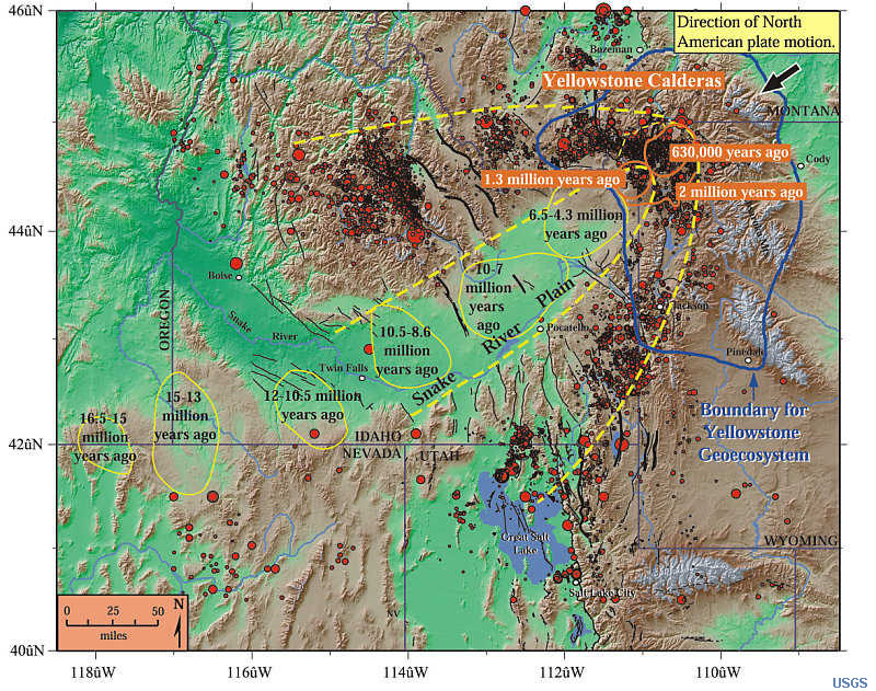 Fig. 4-27. The Yellowstone Hotspot is beneath the North America continent and is slowly migrating eastward as the continent is moving westward. |
| Hot topic: Are hotspots related to "astroblemes" (large asteroid impacts)? Earth has been hit by many asteroids throughout the geologic past. If Earth didn't have an atmosphere and active plate tectonics it would appear heavily cratered like the moon! Current research suggests that massive asteroid impacts can deeply penetrate and fracture the lithosphere, allowing craters to flood with lava—the magma generated by both the impact and material flooding upward to the surface from deeper down. The question is, do astroblemes turn into hotspots? Also, it has been suggested that shock waves from a massive impact can travel through the Earth and will concentrate energy at the "antipoles" - resulting in deep fracturing of the lithosphere, resulting in massive volcanic eruptions. Examples of two possible "antipole" eruptions include the formation of the Deccan Traps in India (opposite the K/T boundary impact ~66 million years ago in the Yucatan region of Mexico. Another massive flood eruption occurred about 250 million years ago, forming the massive Siberian Traps (massive flood basalts that formed about the time of the great end-of-Permian extinction). |
What drives plate motions?• Researchers agree that convective flow in the mantle is the basic driving force of plate tectonics (Figure 4-28).Forces that drive plate motion: • Slab-pull - the slow pull of mantle material where is moves from a rising location to a sinking location. • Slab-suction - The high density of cold ocean crust sinking into the mantle pulls crust with it. • Ridge-push - new ocean crust is warm and tends to rise above the ocean floor, pushing older cooler crust away Plate tectonics model explains many aspects of the geometry of continents and ocean basins and the processes creating new oceanic and continental crust. Material that does not become incorporated into the lithosphere sinks and becomes incorporated back into the mantle. Importance of plate tectonics • The theory provides explanations for many of earth’s major processes • Explains the geologic distribution of earthquakes, volcanoes, and mountains • Explains the distribution of ancient organisms and mineral deposits • Plate tectonics are responsible large volumes of oil and gas deposits we enjoy today. Think about how your life and society would be different if we only had a mere fraction of the hydrocarbons we currently have and use. |
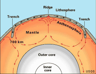 Fig. 4-28. Mantle convection is the driving force of motion of lithospheric plates. Much of the convection motion may be in the upper mantle, but it is likely to extend deep into the earth's molten outer core. |
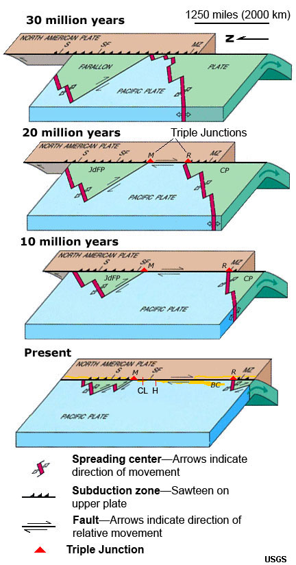
| How does Plate Tectonics explain why continental landmasses are so old (compared to ocean crust)? The interior of the earth is very hot—the source of this heat is thought to be left over from the formation of the planet several billion years ago. As shown in Figure 4-28, the combined effect of the internal heat of the Earth and the force of gravity drive convection currents within the Earth . Heat things up, they expand, become less dense, and the material rises. Cool things down, they condense, increase in density, and the material sinks. This can be easily demonstrated the way hot air balloon rise and fall, or the way currents move when water is heated, or the way currents within a boiling pot of soup rises and sinks when it cools (Figure 4-29). When new ocean crust forms in spreading centers, it is still hot for a time, but it eventually cools by having contact with the cold, deep ocean waters. As a result, old ocean crust is enriched in dense minerals. As it ages, it also absorbs water from the ocean and is becomes blanketed with marine sediments. Where subduction takes place, cold, dense ocean crust sinks back into the mantle. However, as the old crust sinks, it heats up and some of the materials within it melts (assisted by the presence of water and other gases). The materials that melt rise as hot fluids (magma and gases) through the overriding continental crust, forming large magma filled chambers that eventually crystallize into rock at depth, some of which erupts at the surface to form volcanoes. The new rocks that form along the continental margins are less dense than the original oceanic crustal rocks, therefore they eventually isostatically float and rise above the ocean surface, becoming land. Over time, more and more of this lighter rock accumulates first forming volcanic island chains. These volcanic arc and the sediments they shed eventually becomes scraped off and crushed onto the margin of continents—often pushed up as coastal mountain ranges. It this manner, continents grow slowly around their margins in a process called accretion. This process explains why the oldest rocks occur in the shield regions of continents and younger material occurs along continental margins. Continental AccretionAccretion is a process by which material is added to a tectonic plate or a landmass. This material may be sediment, volcanic arcs, seamounts or other igneous features, or blocks or pieces of continental crust split from other continental plates (Figure 4-30 to 4-31). Over geologic time (measured in millions of years), volcanic arcs form and may be crushed onto (or between) colliding continents along plate boundaries. Pieces of continental land masses may be ripped away and carried to other locations. For instance, Baja California and parts of southern California west of the San Andreas Fault are being ripped away from the North American continent and are slowly being carried northward. These rocks may eventually pass what-is-now San Francisco, and perhaps 70 to 100 million years from now will be crushed and accreted into the landmass currently known as Alaska! The entire West Coast of North America is made up of massive fault-bounded blocks of crust (called terranes).A terrane is a fault-bounded area with a distinctive stratigraphy (collection of rocks), structure, and geologic history compared with surrounding terranes or land masses. |
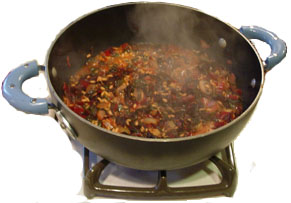 Fig. 4-29. Currents in boiling soup demonstrates convection. The "broth" rises, cools, and sinks (like the formation and destruction ocean crust over time). In contrast, the bubbly "froth" builds up in patches over where cool soup sinks back into the pot. The buildup of froth in patches is similar to the way continents build up over time. |
| Another YouTube video: Continents Adrift An Introduction to Continental Drift and Plate Tectonics This video explains much of what this chapter reviews. |
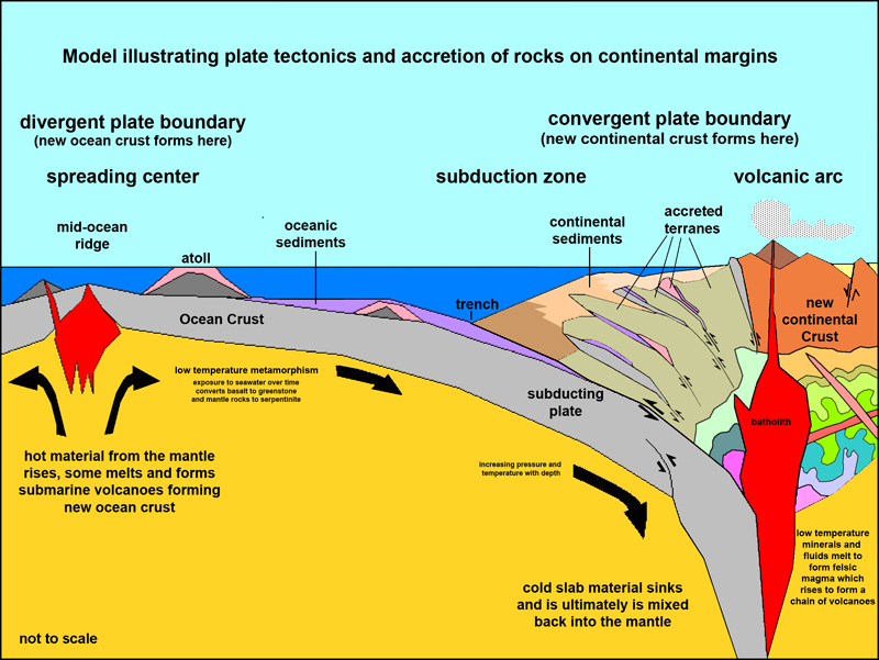 |
Fig. 4-30. Plate tectonic model: Subduction introduces oceanic crustal rocks (including sediments) back into the asthenosphere. Water and gas helps low-temperature minerals to melt and rise as, forming new continental crust (less dense than oceanic crust). Floating on the Asthenosphere, the continental crustal materials accumulate, forming continents. | 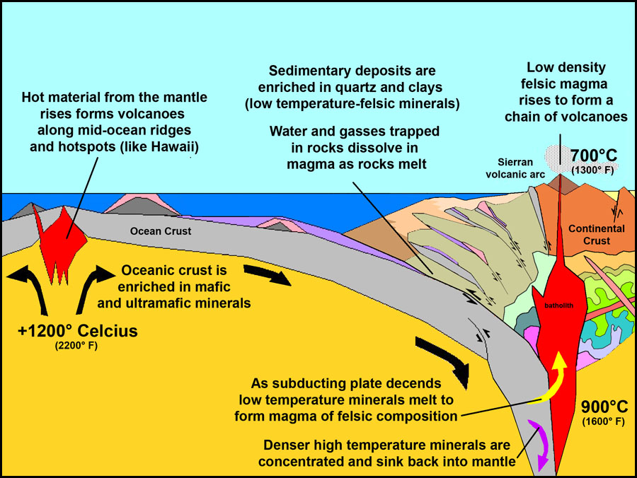 |
Fig. 4-31.The processes associated with subduction lead to the accretion (growth) of continents over time. As ocean crust is recycled back into the upper mantle, the lighter material accumulates near the surface along continental margins. Pieces of lithosphere are sometimes scraped off one plate and crushed onto and added (accreted) to another plate. |
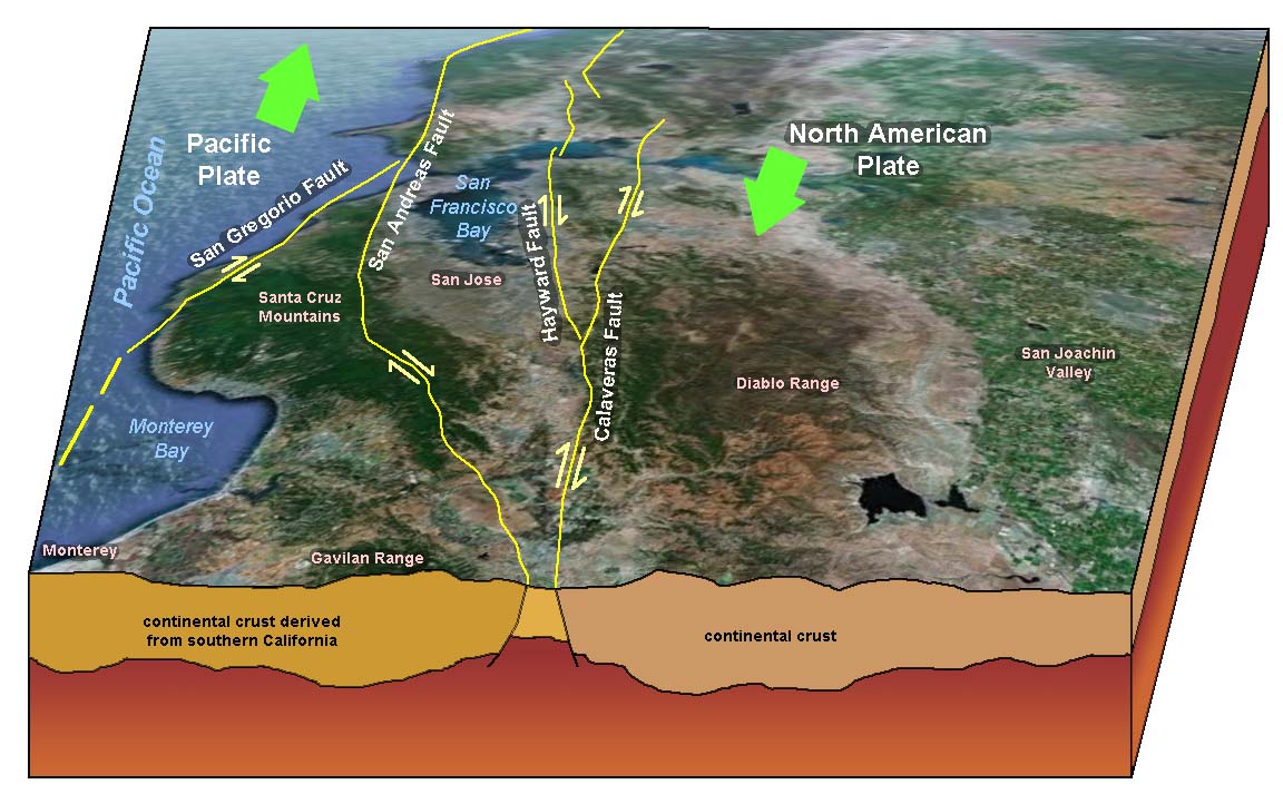
| Fig. 4-32. Terranes in the San Francisco Bay area. This cross section of the Santa Clara Valley (south of San Jose, California) shows several fault-bounded terranes. Each of the large crustal blocks formed in locations far south of the Bay Area, but have gradually moved north along the fault system that bifurcates through the region. Over time, California has formed (assembled) by the accretion of terranes (small crustal landmasses) carried in by plate-tectonic processes slowly over geologic time. | 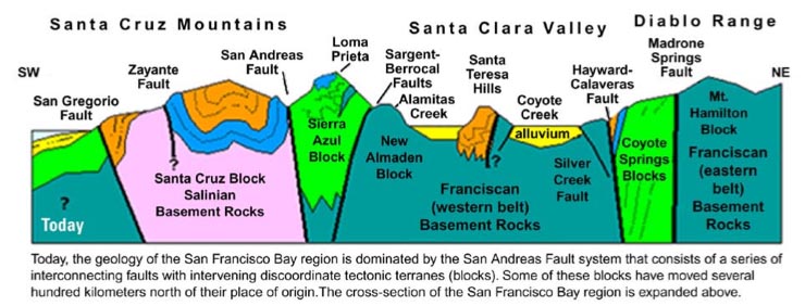 |
Ancient Parts of Continents: Cratons and ShieldsA craton is a part of a continent that is stable and forms the central mass of the continent. The craton region of North America includes the region between the Rocky Mountains (to the west) and the Appalachian Mountains (to the east) and include the Canadian Shield.A shield is a large area of exposed Precambrian-age crystalline igneous and high-grade metamorphic rocks that form tectonically stable areas. In all cases, the age of these rocks is greater than 570 million years and sometimes dates back 2 to over 4 billion years. For instance: the Canadian Shield is part of the North American craton region. Shallow inland seas have flooded over and retreated from North America's craton/shield region in the past billion years. |
|||
 |
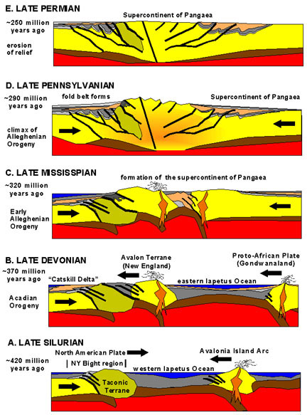 |
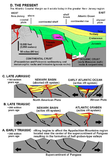
Formation and Breakup of Pangaea Through geologic time new continental crust forms and accumulates along the margins of continents. The "floating" continental crust eventually crashes into other land masses, and these terranes may assemble into larger continental crustal plates. For instance, the formation of the ancient supercontinent Pangaea assembled through continental accretion. Pangaea later gradually split apart by continental rifting forming the world's continental landmasses that exist today. The geologic story of the formation and breakup of Pangaea are preserved in the rock record all along the Atlantic Margin of North America, Europe, and Africa. |
 |
| Fig. 4-33. Continental shields and cratons | |||
| Continental shields contain the oldest rocks preserved in the cores of continental landmasses. These regions formed by processes associated with continental accretion billions of years ago, long before the continents of the modern world existed. These ancient shield are part of the stable parts of continents (cratons) and in many places are partially covered by younger sedimentary rocks (such as in the Great Plains and Midwestern Low Plateau regions of North America). | |||
| Fig. 4-34. Formation of Pangaea by closing of the "proto-Atlantic" Iapetus Ocean about 300 million years ago. | Fig. 4-35. Breakup of Pangaea and formation of the Atlantic Ocean about 200 million years ago. | ||
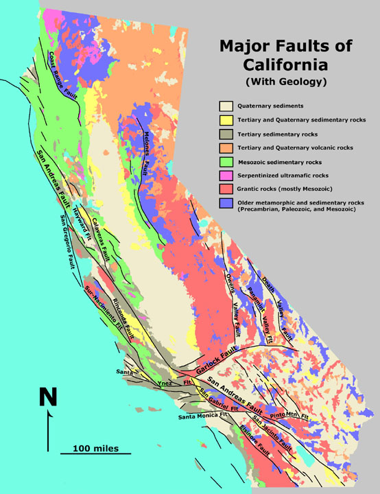
California Geology and Plate Tectonics History
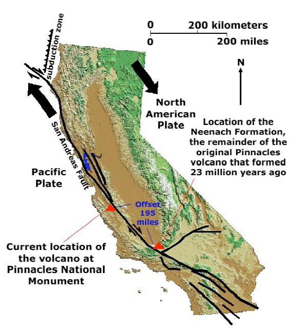
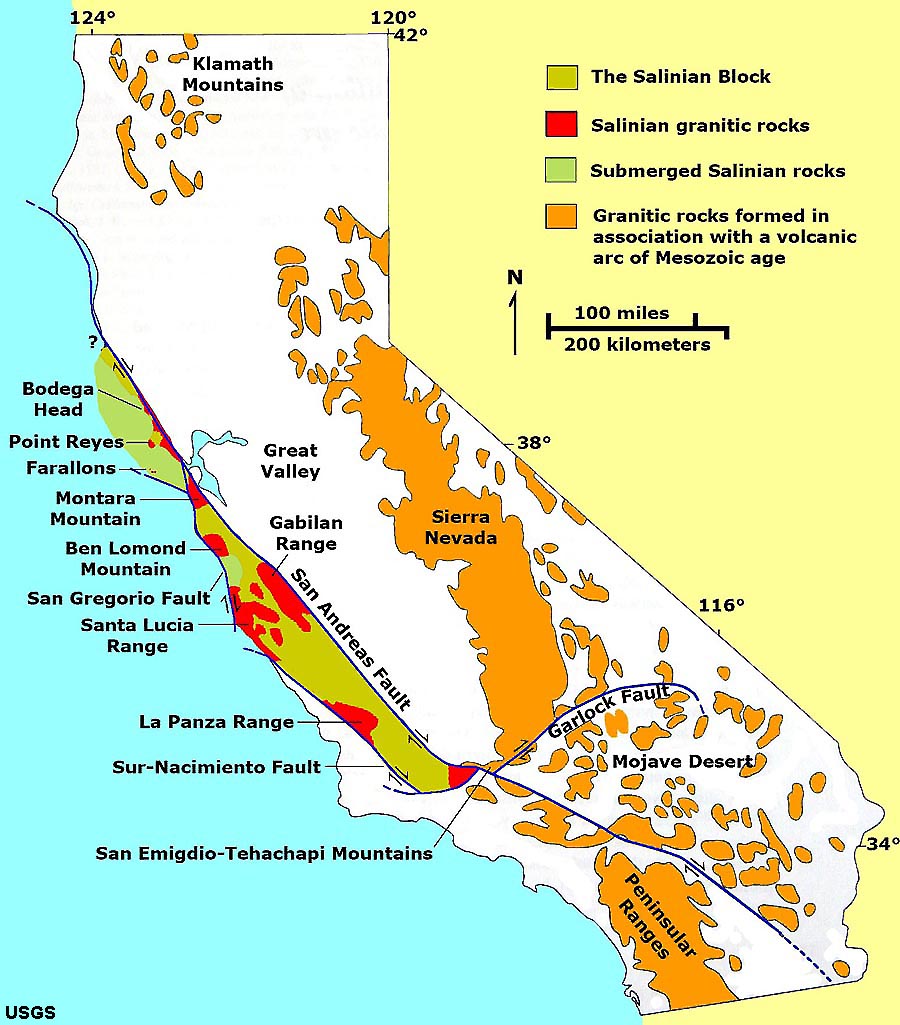
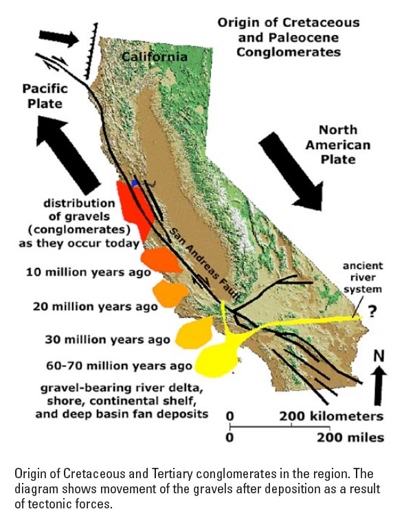
Supporting evidence of long-distance movement along the San Andreas Fault System. |
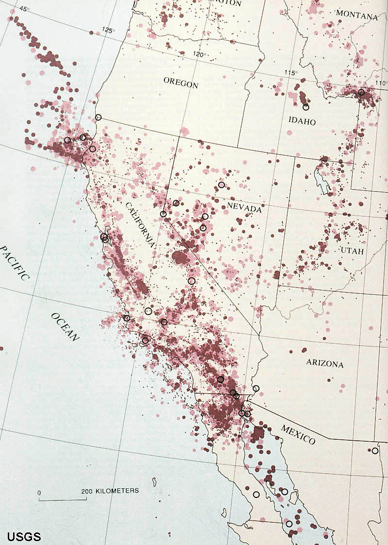
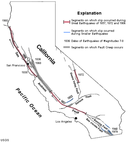
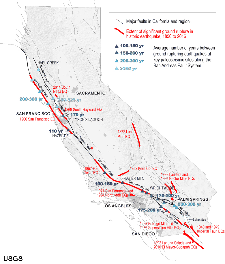
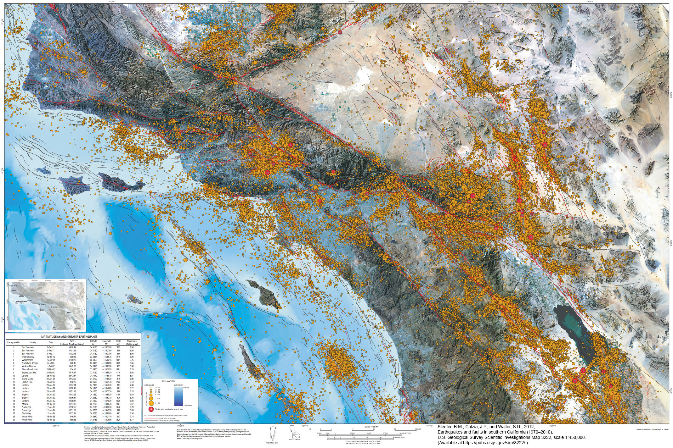
Faults, Earthquake Faults, and Earthquakes in SoCal (Southern California)Southern California is a very geologically active region. The maps below are very useful for understanding the nature of earthquake hazards in the region. Figure 4-43 shows the location of major historic earthquakes including regions where the major fault displayed surface ruptures and the number of years between major ground-rupturing events where they've been studied in important locations.Figure 4-44 is a map showing SoCal's regional seismic activity as illustrated with the location of earthquake data recorded between the years of 1970 to 2010. It is interesting to study this map to see which faults, or fault systems were most active within this time window. Faults that do not show a lot of seismic activity on this map may indicate three possible scenarios: 1) the fault is no longer active, 2) the fault already experience an earthquake, and has released most of its stored up energy before 1970, or 3) the fault is locked up and is potentially going to possibly create a major earthquake in the future. It is interesting to study the landscape geography (both topography and bathymetry) relative to the location of the faults on this map. In most cases, the faults are associated with a mountain front (both on land and offshore). Figure 4-45 shows a map of some of the major earthquake faults in Southern California, displaying characteristics of the faults below the surface. Faults shown as narrow lines are have a vertical orientation, whereas the wider lines show that the faults penetrate into the crust at a low angle (thrust faults). Many of the fault show a component of both horizontal or vertical segments. Almost all the faults are interconnected with other faults in the region. These maps show that the potential for major earthquake may occur both on land or offshore. The ones located offshore could possibly generate massive tsunamis along the SoCal coastline. |
|||
|

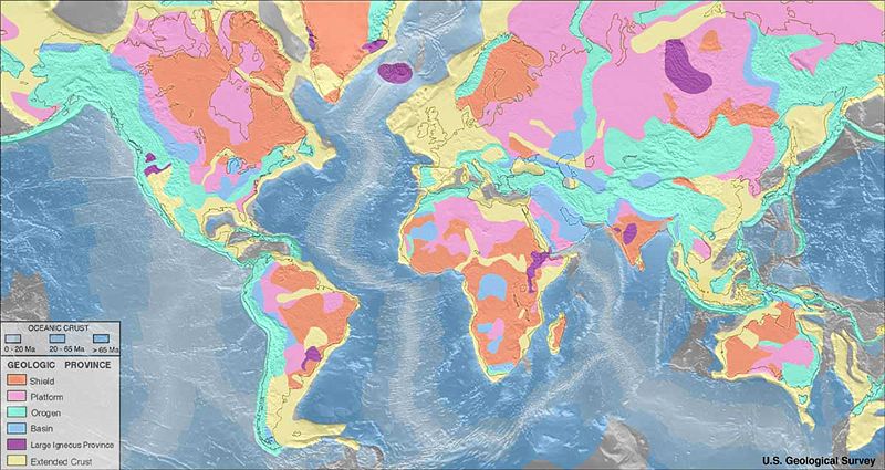
| Recommend reading! Learn more about Plate Tectonics Theory at these online resources prepared by the Smithsonian Institution and U.S. Geological Survey: This Dynamic Earth (The Story of Plate Tectonics) - this on-line booklet is used for teaching plate tectonics at schools and universities around the world. It has a companion map: This Dynamic Planet (World Map of Volcanoes, Earthquakes, Impact Craters, and Plate Tectonics (see Figure 4-46). Crustal age of the Seafloor Map: National Oceanic and Atmospheric Administration, National Geophysical Data Center |
 |
| Fig. 4-46. Plate Tectonic Features Map from "This Dynamic Planet." |
Selected Earthquake Fault Information and Scenarios In CaliforniaSan Diego Earthquake Planning Scenario, Magnitude 6.9 of the Rose Canyon Fault Zone, Executive SummaryPrepared by the Earthquake Engineering Research Instutude, San Diego Chapter. Animation of the Scenario M6.9 Earthquake on the Rose Canyon Fault (USGS/SCEC) Southern California Earthquake Simulation 2016 - M7.8 This is an animation of the most likely scenario and effects for the next big earthquake in Southern California. ShakeOut Scenario - Los Angeles, Detailed Perspective This is an animation of the most likely scenario and effects for the next big earthquake as illustrated for Los Angeles. Computer Simulation of an Earthquake | California Academy of Sciences A simulation of a potentially large earthquake on the Hayward Fault in the San Francisco Bay Region. Field guides to the San Andreas Fault and other regional faults in the San Francisco Bay region.Where’s the San Andreas Fault? A Guidebook to Tracing the Fault on Public Lands in the San Francisco Bay RegionWhere's the Hayward Fault? A Green Guide to the Fault |
| Chapter 4 Quiz Questions |