Muav Limestone
Muav Limestone of Tonto Group (AZ*)
Muav Limestone (NV*,UT*)
Muav Marble (CA*)
Muav Dolostone (AZ*)
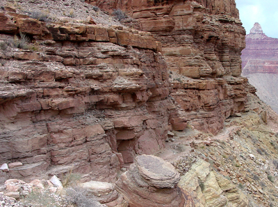
Beds of Muav Limestone along Grand Canyon's South Kaibab Trail.
Cambrian, Middle*
Middle Cambrian - 505 million years
(age used by National Park Service;
Mathis and Bowman, 2005)
Plateau sedimentary province*
Salton basin
Great Basin province*
AZ(n)*
CA(se)*
NV(s)*
UT(sc)*
Not designated. Named for Muav Canyon, north side of Colorado River, in either Shinumo quad or Havasupai Point 15' quad [Discrepancy in GNU files], Coconino Co., AZ (Noble, 1914).
(alphabetical): Boucher Tongue (AZ), Elves Chasm Tongue (AZ), Gateway Canyon Member (AZ), Havasu Member (AZ), Kanab Canyon Member (AZ), Lava Falls Tongue (AZ), Parashant Tongue (AZ), Peach Springs Member (AZ), Rampart Cave Member (AZ), Sanup Plateau Member (AZ), Spencer Canyon Member (AZ), Yampai Cliffs Member (AZ).
Named as upper formation of Tonto Group (Noble, 1914). Revised, divided into Rampart Cave, Sanup Plateau, Spencer Canyon, Kanab Canyon, Gateway Canyon, and Havasu Members [members not adopted]; Upper contact revised; Overview (McKee, 1945). Areal limits (Peterson and Barnum, 1973). Revised; Redescribed as Muav Marble in CA; Areal limits (Hamilton, 1982). Revised (Billingsley and others, 1989). Redescribed as dolostone (Poole and others, 1992).
Muav Limestone (Middle Cambrian)—Dark-gray, light-gray, brown, and orangered, cliff-forming limestone, dolomite, and calcareous mudstone. Includes, in descending order, unclassified dolomites, and Havasu, Gateway Canyon, Kanab Canyon, Peach Springs, Spencer Canyon, and Rampart Cave Members of McKee and Resser (1945). These members consist of fine- to medium-grained, thin to thick-bedded, mottled, fossiliferous, silty limestone, limestone, and dolomite. Three unnamed slope-forming siltstone and shale units of Bright Angel Shale lithology are intertongued between cliff-forming members of Muav Limestone. These unnamed siltstone and shale units are green and purplish-red, micaceous siltstone, mudstone, and shale, and thin brown sandstone. Contact with the underlying Bright Angel is gradational and lithology dependent. Contact is arbitrarily marked at base of lowest prominent cliff-forming limestone of Rampart Cave Member of the Muav in western half of map area, and of Peach Springs–Kanab Canyon Members of the Muav in eastern half of map area. All members of the Muav thicken from east to west across map area. However, the Peach Springs, Spencer Canyon, and Rampart Cave change to purple-red and green siltstone/shale facies of the Bright Angel in eastern half of map area, where they are included as part of the Bright Angel . Intertonguing and facies change relationships between the Muav and Bright Angel produce variable thickness trends. Overall, the Muav thickens from about 350 ft (107 m) in eastern part of map area to about 600 ft (183 m) in western part.
References
Noble, L.F., 1914, The Shinumo quadrangle, Grand Canyon district, Arizona: U.S. Geological Survey Bulletin, 549, 100 p., (incl. geologic map, scale 1:48,000).
McKee, E.D., 1945, Stratigraphy and ecology of the Grand Canyon Cambrian,
Part 1; Cambrian history of the Grand Canyon region: Carnegie Institution
of Washington Publication, no. 563, p. 1-170.
McKee, E.D., and Resser, C.E., 1945, Cambrian history of the Grand Canyon region: Carnegie Institution of Washington Publication 563, 232 p.
Peterson, Fred and Barnum, B.E., 1973, Geologic map and coal resources of the northeast quarter of the Cummings Mesa quadrangle, Kane County, Utah: U.S. Geological Survey Coal Investigations Map, C-63, 2 sheets, scale 1:24,000.
Hamilton, Warren, 1982, Structural evolution of the Big Maria Mountains, northeastern Riverside County, southeastern California, IN Frost, E.G., and Martin, D.L., editors, Mesozoic-Cenozoic tectonic evolution of the Colorado River region, California, Arizona, and Nevada; Anderson-Hamilton volume: San Diego, CA, Cordilleran Publishers, p. 1-27, Published in conjunction with the Geological Society of America symposium and field trip, April, 1982.
Billingsley, G.H., Elston, D.P. and Kieffer, S.W., 1989, Geologic log of Colorado River from Lees Ferry to Temple Bar, Lake Mead, Arizona, Part II, IN Elston, D.P., Billingsley, G.H., and Young, R.A., editors, Geology of Grand Canyon, northern Arizona (with Colorado river guides); Lees Ferry to Pierce Ferry, Arizona; guidebook to field trips T115 and T315: International Geological Congress, 28th, Field Trip Guidebook, T115, T315, Washington, DC, 1989, p. 1-36.
Poole, F.G., Stewart, J.H., Palmer, A.R., Sandberg, C.A., Madrid, R.J., Ross, R.J., Jr., Hintze, L.F., Miller, M.M. and Wrucke, C.T., 1992, Latest Precambrian to latest Devonian time; development of a continental margin, Chapter 2, IN Burchfiel, B.C., Lipman, P.W., and Zoback, M.L., editors, The Cordilleran Orogen; conterminous United States: Geological Society of America, The Geology of North America, The Decade of North American Geology (DNAG), v. G-3, p. 9-56
Korolev, Viacheslav S., and Rowland, Stephen M., 1998, Sequence stratigraphy and correlation of the supra-Muav undifferentiated Cambrian dolomites of the Grand Canyon and Lake Mead region: Geological Society of America, Abstracts with Programs, v. 30, no. 5, p. 49.
Middleton, Larry T., and Elliott, David K.,1990, Tonto Group. In, Grand Canyon geology, Beus, Stanley S., and Morales, Michael, editors, unknown pages.
Elston, Donald P., 1989, Correlations and facies changes in Lower and Middle Cambrian Tonto Group, Grand Canyon, Arizona: In, Geology of Grand Canyon, northern Arizona (with Colorado iver guides); Lees Ferry to Pierce Ferry, Arizona; Elston, Donald P., Billingsley, George H., and Young, Richard A., editors, Field trips for the 28th international geological congress: Hanshaw, Penelope M., ed., IGC, International Geological Congress.
Beus, Stanley S., 1987, Geology along the South Kaibab Trail, eastern
Grand Canyon, Arizona
DNAG, Decade of North American Geology, 6 p.
Billingsley, George H., 2000, Geologic Map of the Grand Canyon 30' by 60' Quadrangle, Coconino and Mohave Counties, Northwestern Arizona: U.S. Geological Survey Geologic Investigation Series I-2688, Available on-line at: http://pubs.usgs.gov/imap/i-2688/.).
Mathis, A. and Bowman, C., 2005, What's in a number? Numeric ages for rocks exposed within the Grand Canyon, Part 2: Nature Notes ( Grand Canyon National Park ), v. 21, no. 2, p. 1-5.