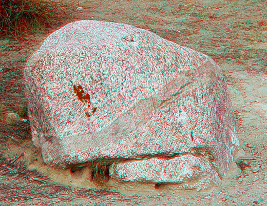
This granitic boulder is derived from the Paso Robles gravels -- ancient stream deposits that filled a valley along the San Andreas Fault during the Late Pliocene and Early Pleistocene Epochs. Note the igneous intrusion running diagonally across the boulder. This is a typical feature of Mesozoic age derived from plutonic (intrusive igneous) rocks of from the Sierra region.
Starting about 2.5 million years ago, sediments derived from the southern Sierra region began accumulating in an alluvial plain setting (stream and floodplain deposits). About that time (and continuing into the present), the Temblor Range and other coastal ranges began to rise and shed sediments into the developing rift basin along the San Andreas Fault. This younger alluvial fill is called the Paso Robles Formation (named after similar deposits in the Salinas Valley to the west). In the Carrizo Plain these deposits are also referred to as the Paso Robles gravels (because of their unconsolidated character). Since these deposits formed they have been folded and offset by uplift and lateral motion along the San Andreas Fault. The entire Carrizo Plain has been uplifted about 1,000 feet since deposition of the Paso Robles gravels has ended sometime in the late Pleistocene Epoch. The Soda Lake basin eventually became an isolated, internal-drained basin when regional drainages were blocked or captured because of motion along the San Andreas Fault. Stream channels flowing westward from the Temblor range have been blocked or diverted by as much as one-half mile by the uplift and offset of the San Andreas Fault through the Elkhorn Hills. The Paso Robles gravels have been structurally uplifed into a broken anticlinal fold and eroded from the crest of the hills (Dibblee, 1962).
The Paso Robles gravel consists of a mix of clasts of Monterey Formation (porcellanite and siliceous shale) derived from the Coast Ranges and Temblor Range, and contain intrusive igneous and metamorphic rocks derived from the San Emigdio Mountains (located at the southern end of the San Joaquin Valley near the intersection of the San Andreas and Garlock Faults -- about 70 miles south of Soda Lake). These gravels show as much as 10 miles (16 kilometers) of offset along the San Andreas Fault since they were deposited (Dibblee, 1953).