Click here to start a 3-D
tour of the park. You will need 3-D glasses to view this series of anaglyphic
images.
Click on any of the images to continue to the next page in the linked series of web pages.
|
|
|
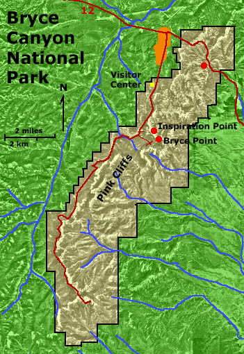
Map of Bryce Canyon National Park. Click on the "Next Image" (below) to continue on the image tour, or click on any of the small red dots on the map above to go directly to selected images. |
| Click here to see more geology tours of National Parks. |
|
Check out the National Park Service's Bryce Canyon National Park site - http://www.nps.gov/brca/ Click here to see information about park stratigraphy and historic geologic reports. To see a geologic map and description of the park geology see: William E. Bowers, 1991, Geologic Map of Bryce Canyon
National Park and Vicinity, Southern Utah: U.S. Geological Survey, Miscellaneous
Information Series Map I-2108, scale 1:24,000. This website is an image tour of Bryce Canyon National Park. All pictures were taken in early June 2003. The 3D images are anaglyphs, and require red and cyan 3-D viewing glasses. The image below is a pair of 3-D (anaglyph) viewing glasses. |
 |
A search on the World Wide Web will yield many sites about anaglyphs and where to get 3-D glasses. |
| This page is <https://gotbooks.miracosta.edu/gonp/brca/> Last modified Mon 1/19/2011 |