
Regional Geology of the United States |
Introduction to Physiographic Provinces of the United States |
| Getting to know the general geology of a region is useful in many ways. Geologic features such as faults, folds, volcanic intrusions, both modern and ancient, provide the foundation for landscapes. Rock materials that occur in bedrock weather into sediments and soils that influence agricultural uses and their characteristics are important factors in building foundations and infrastructure. Often geologic features have influenced how and where cities have started and evolved, or where major industries have evolved in association with natural resources in a region. This website is an introduction to the geology of major physiographic regions of the United States (Figure 1). The science of studying landscapes is called geomorphology (geo- meaning "earth" and -morphology meaning "shape"). A physiographic province is a geographic region with a characteristic geomorphology in which climate and geologic factors—over time—have given rise to a variety of landforms different from those of surrounding regions. Continents are subdivided into various physiographic provinces, and each province has specific characteristics, topographic relief, and physical environments which contributes to its uniqueness. Physiographic region boundaries often follow similar boundaries to ecoregions used in ecological mapping the biological sciences (see US EPA website on Ecoregions of North America). |
Physiographic Provinces Map of the United States |
 |
| Figure 1-A. Physiographic Provinces of the United States on a shaded relief map. For larger versions of the map above click on: SMALL | MEDIUM | LARGE |
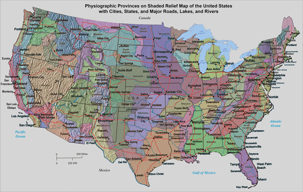 |
| Figure 1-B. Physiographic Provinces of the United States on a shaded relief map showing cities, states, major highways, lakes, and rivers. For larger versions of the map above click on: SMALL | MEDIUM | LARGE |
Physiographic Regions of the United States |
Take a tour of the physiographic provinces |
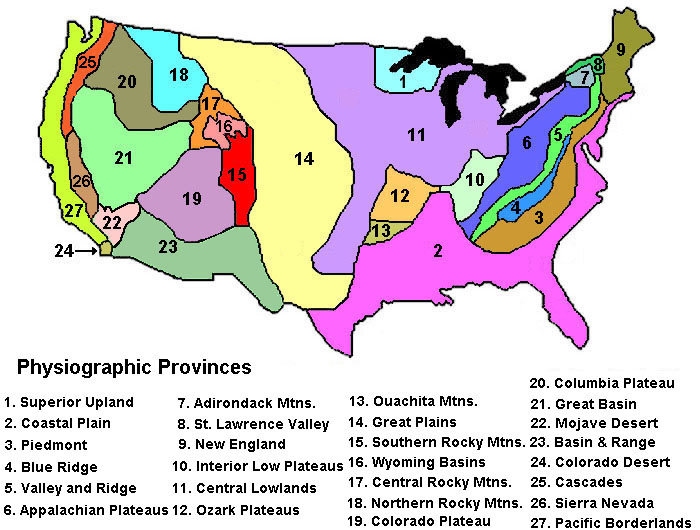
Links to Physiographic Regions1. Canadian Shield-Superior Uplands Province2. Atlantic and Gulf Coastal Plains Appalachian Mountains Provinces -- 3. Piedmont Province -- 4. Blue Ridge Mountains Province -- 5. Valley and Ridge Province -- 6. Appalachian Plateaus Province -- 7. Adirondack Mountains Province -- 8. St. Lawrence Valley Province -- 9. Northern Appalachians (New England) Mid-Continental Regions -- The Great Lakes -- 10. Interior Low Plateaus Province -- 11. Central Lowlands Province South-Central Interior Regions of the US -- 14. Ozark Plateau Province -- 13. Ouachita Mountains Province -- Anadarko Basin 14. Great Plains Province -- High Plains and Plateaus of West Texas -- Permian Basin (TX & NM) -- High Plains of Eastern New Mexico -- Central Great Plains(CO, KS, NB, WY) -- Northern Great Plains (SD, ND, MT) North American Cordillera --15. Southern Rocky Mountains -- 16-17. Central Rocky Mtns. & WY Basins -- 18. Northern Rocky Mountains 19. Colorado Plateau (AZ, CO, NM, UT) 20. Columbia Plateaus -- Snake River Plain & Yellowstone Hotspot Western Desert Provinces -- 21. Great Basin Province -- 22. Mojave Desert Province -- 23. Basin and Range Province -- 24. Colorado Desert Province 25. Cascades Province 26. Sierra Nevada Province 27. Pacific (West Coast) Borderlands -- Pacific Northwest (WA) -- Great Valley Province -- Coast Range Provinces (OR & CA) -- Transverse Ranges of Southern California -- Peninsular Ranges Alaska Hawaii |
|||
 |
|||
| Fig 2. Physiographic Provinces of the conterminous United States | |||
History of Physiographic ProvincesOnce the country was "mapped," attempts began to classify landscapes by mutual characteristics: topography, bedrock geology, climate, plants and ecosystems, etc. (Figures 1, 2, and 3).Perhaps the most notable (and widely used) is based on the maps by geologist and geographer, Nevin M. Fenneman (see references below). His mapping efforts have been used and modified over the years, but are still very useful for teaching about regional geology and ecosystems. |
|||
| Published maps by Nevin M. Fenneman Fenneman, N. M. (1917). Physiographic Subdivision in the United States. Proceedings of the National Academy of Sciences of the United States 3 (1): 17-22. Fenneman, N. M. (1931). Physiography of western United States. McGraw-Hill. Fenneman, N. M. (1938). Physiography of eastern United States. McGraw-Hill. |
|||
"Take a tour" of the physiographic provinces of the United States |
|||
 |
Take a tour of the physiographic provinces of the United States by clicking on the "next page" link on the bottom of each of the following web pages. This series of web pages include photographs the generally illustrate the nature of the landscape in each region and includes maps, satellite images, and other graphics that are intended to supplement the descriptions of each region. |
||
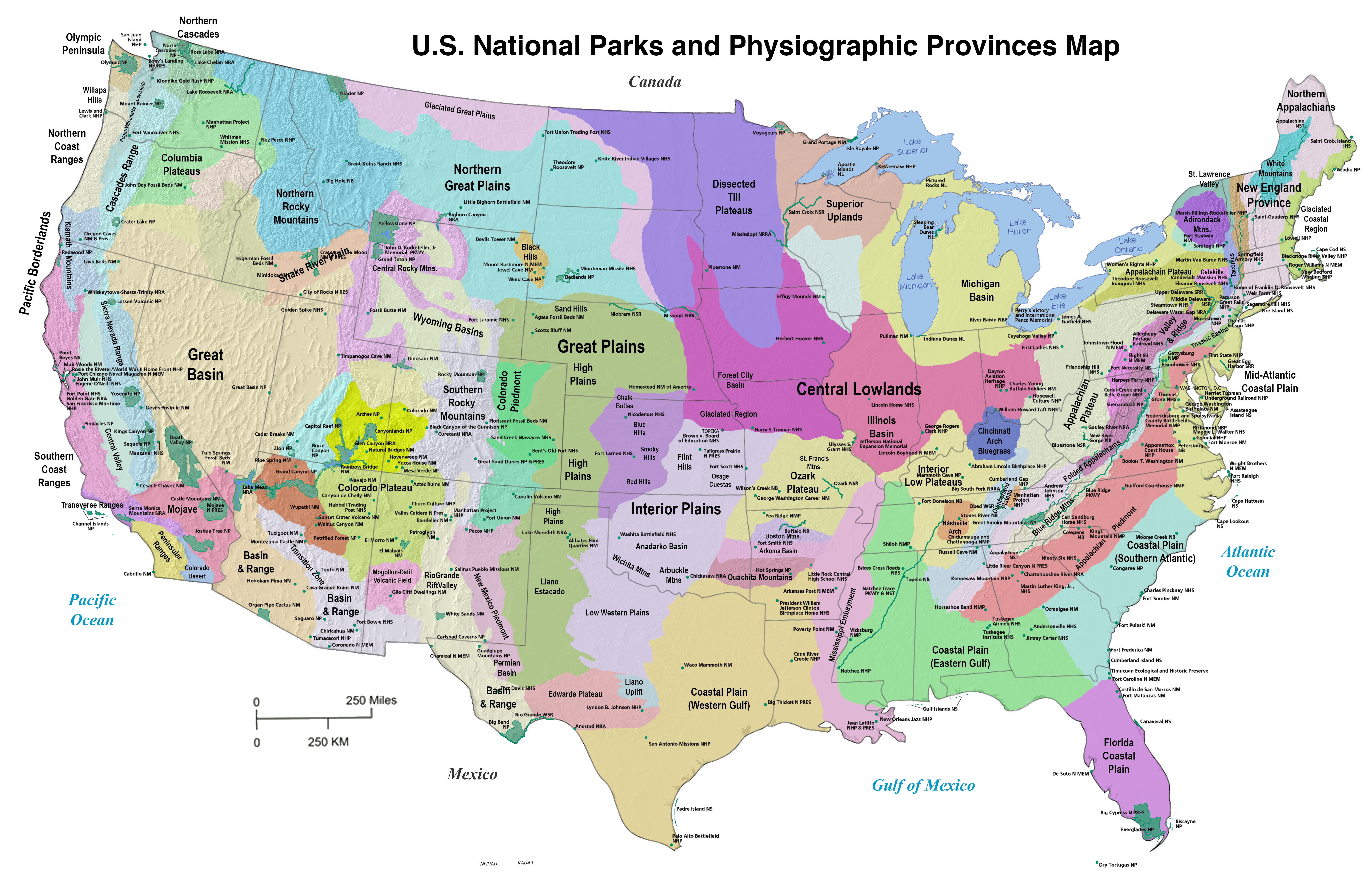
U.S. National Parks and Physiographic ProvincesNational parks often contain some of the most scenic and illustrative geologic features associated with physiographic provinces they are located within.Click here or on the map to the right to download a large .jpg version of a physiographic provinces map showing the locations of U.S. National Park, Monuments, and other National Park Service sites in the lower 48 states. See the Geology of National Parks website to view imagery and information about the natural resources, geology, rocks, and landscapes of selected U.S national parks and monuments. |
 |
Physiographic Regions and Geology of North America |
Click on images for a larger view. |
|
| Figure 3 shows is a general geologic map of North America showing the major physiographic subdivisions. Figure 4 is a legend showing the geologic ages of bedrock used for Figure 3 and Figure 5—as well as most of the other maps presented throughtout this website. Figure 5 is a generalized summary of geologic history, with important events involving the evolution of North America and evolution of life through geologic time. | 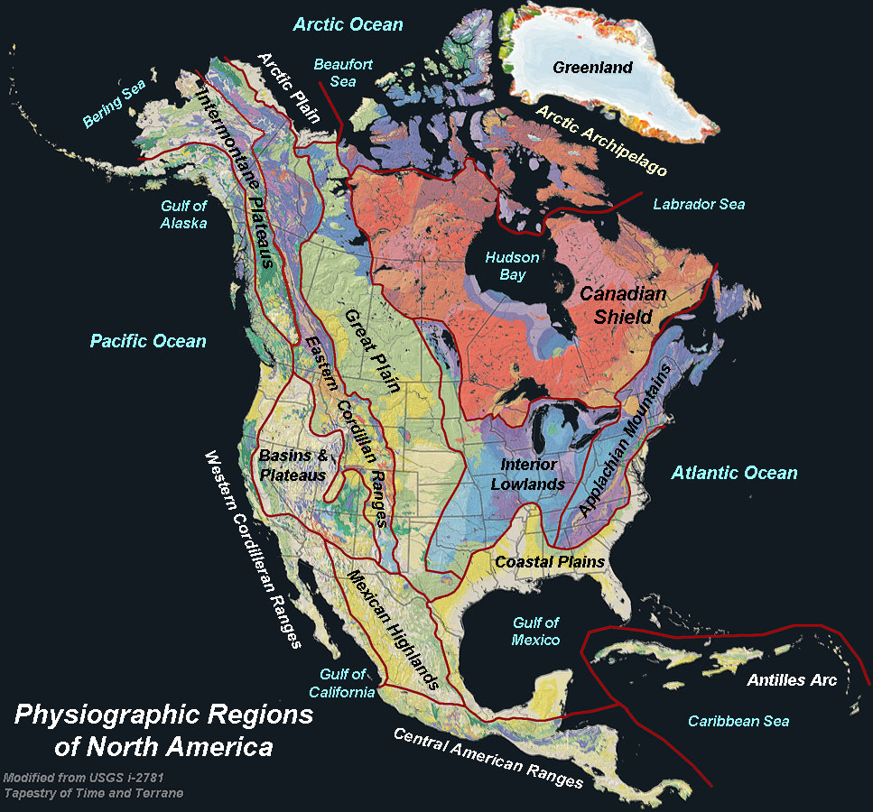 Fig. 3. Major physiographic regions of North America and vicinity. |
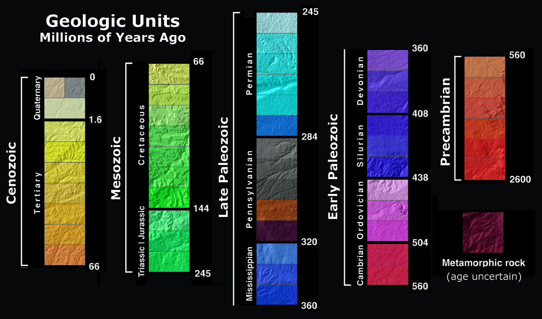 Fig. 4. Ages of rock units used on maps and in discussions throughout this website. Colors represent ages of bedrock exposed at or near the surface corresponding to different geologic time periods. |
| Note: maps used in this report are derived (modified) from sources including: The North America Tapestry of Time and Terrain (2003) by Kate E. Barton, David G. Howell, José F. Vigil: USGS Geologic Investigations Series map I-2781. A Tapestry of Time and Terrain (2000) by José F. Vigil, Richard J. Pike, and David G. Howell: USGS Geologic Investigations Series 2720. |
||
Importance of regional physiographic surveys in the history of the United StatesAs the nation of the United States of America expanded westward in the 19th Century, much of the western region was generally unknown territory. The historic expedition of Lewis & Clark (1804-1806) was intended to map and explore the vast lands acquired by Louisiana Purchase of 1803. The goal was to find a practical route across the western landscape and to establish an American claim to land before other European nations could claim it. Their goal was also to learn about American Indian tribes, and to study the region’s geography, plants, and wildlife. After the Mexican-American War of 1848, the United Stated claimed Spanish Territories encompassing California, most of the Desert Southwest region, and Texas. The addition of these vast territories required many more expeditions to expand the country. Perhaps most significant events was the discovery of gold in the Sierra Nevada foothills which led to the California Gold Rush of 1849—which unleashed perhaps the greatest human migration in its time, and began the extensive exploration efforts to map and exploit the natural resources of the western United States.Four Great Surveys of the American WestPlanning and construction began on the First Transcontinental Railroad in 1863, during the Civil War (1861-1865). It was completed in 1869, connecting the port of San Francisco to the expanding railroad network along the Mississippi and Missouri River in the Midwest. The development of the Western Territories and it mineral resources had become the main focus of national interests. On March 2, 1867, the day after the State of Nebraska was admitted to the Union, Congress enacted legislation to support the United States Geological and Geographical Survey of the Territories. This survey (called the Hayden Survey) focused on the vast region of lands east and within the Rocky Mountains. It was headed by Dr. Ferdinand Vandeveer Hayden who published a series of reports between 1867 and 1883 about the region’s geology, topography, mineral resources, paleontology, and Indian peoples and culture. Also in 1867, Congress authorized Clarence King to lead the first scientific survey of the west (Geological Exploration of the Fortieth Parallel—or the King Survey) to study the geology and natural resources along the 40th parallel, following the general route of the Transcontinental Railroad.In 1869, Congress authorized American naturalist and civil-war veteran, John Wesley Powell, to lead an expedition to study previously unexplored lands along the Colorado River Basin between Green River. Wyoming and the lower navigable waters of the river below what is now Las Vegas. The Powell Geographic Expedition of 1869 received great acclaim throughout the nation. He repeated his voyage 2 years later to photograph and map the route through the canyon region of the upper Colorado River Basin. Interesting note: the Henry Mountains of south central Utah were the last “undiscovered” mountain range in the United States during the Powell Survey. Congress also supported the Hayden Geological Survey of 1871-1872. It focused on exploration of the northwestern Wyoming region that lead to the establishment of Yellowstone National Park (established in March 1, 1872, the first National Park). Army Lieutenant (later Captain) George Montague Wheeler lead early western expeditions in 1869 and 1871 into the west. In 1872 Congress authorized what would be known as the Wheeler Survey with the ambitious task of creating topographic maps of the lands west of the 100th meridian on scale of 8 miles to an inch (~1:500,000). The Wheeler Survey was tasked to describe everything related to the physical features of the landscape, study the numbers, habits, and dispositions of Indians in the region, select sites for future military installations, gather information for charting future railroads and common roads, and make notes about geology, mineral resources, water, climate, vegetation, and agricultural potential of western lands. |
|
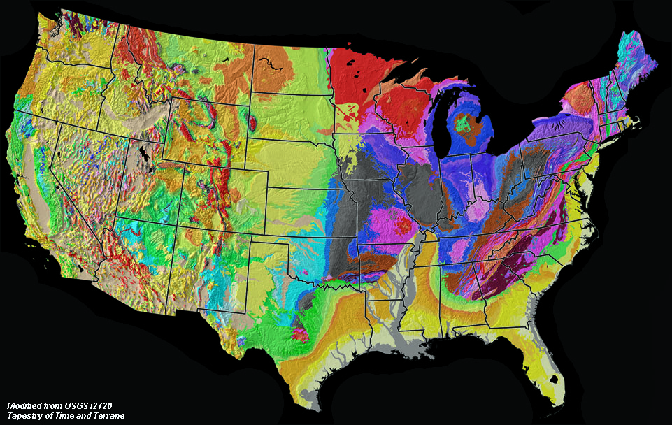 Fig. 5. Geologic map of the United States showing state boundaries. Note that most state boundaries cross multiple physiographic boundaries (with the exception of Delaware, Florida, and Louisiana). Most states have their \ own "geological survey" -- typically integrated into a larger "Department of Natural Resources" or agency with a similar name. All the states work in collaboration with the US Geological Survey and other federal, state, and local agencies and organizations that oversee land use managment, wildlife, and water and natural resources conservation. 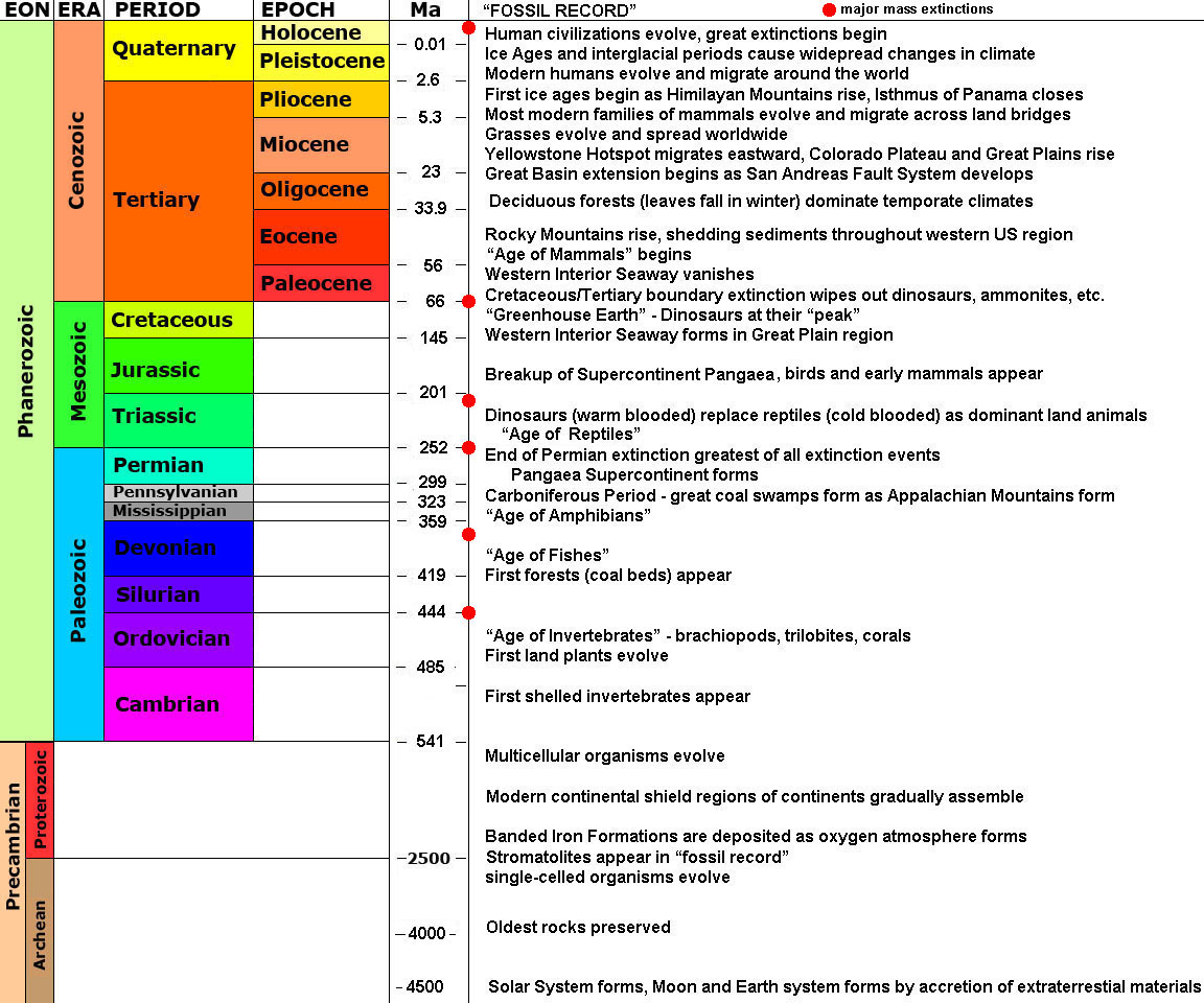 Fig. 6. The geologic time scale (generalized) showing selected highlights in evolution of life on Earth and selected significant events in Earth history leading up to the present. |
|
U.S. Geological Survey (USGS)In 1879, Congress authorized the U.S. Geological Survey and it was given the task to create maps of the country and provide "classification of the public lands, and examination of the geological structure, mineral resources, and products of the national domain." Topographic mapping of much of the populated regions of country was completed on a 1:50,000 scale by the early 20th century, with more detailed 1:24,000 scale mapping (standard topographic maps) for most of the entire US near completion in the 1960s. Today satellite, GPS, and GIS mapping have replaced nearly all "standard" mapping. The current mission of the USGS is to serve "the Nation by providing reliable scientific information to describe and understand the Earth; minimize loss of life and property from natural disasters; manage water, biological, energy, and mineral resources; and enhance and protect our quality of life." Today, the USGS employs thousands of scientists from many natural science disciplines. |
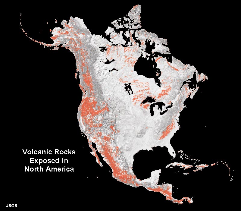
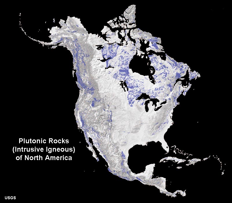
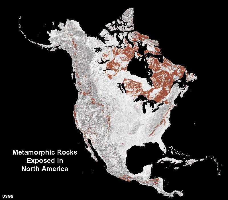
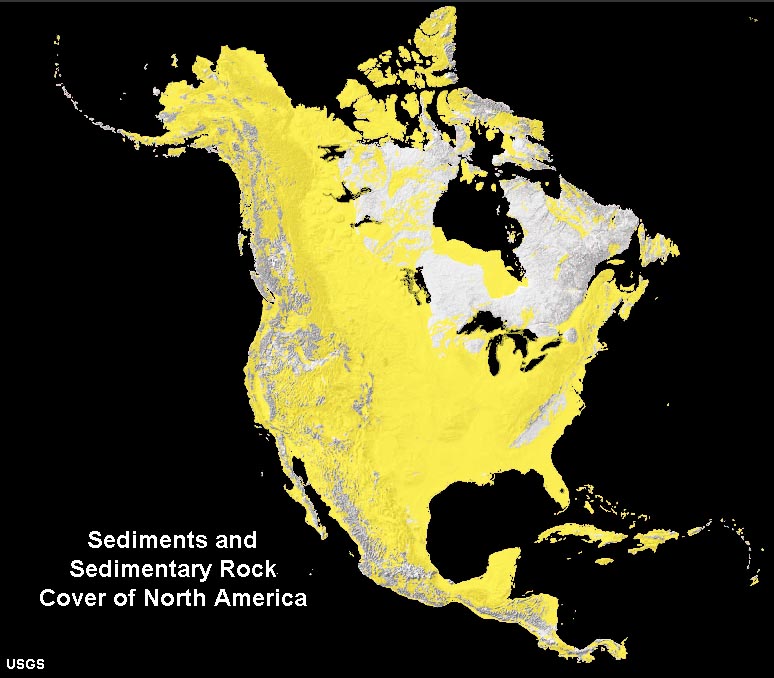
Rocks exposed at the surface throughout North America |
|
Many types of rocks of different ages are exposed at the surface throughout North America. The age and character of the rocks (hardness, chemical composition, etc.) give rise to landscape characteristics and the types of soil and sediments that cover the surface. Figure 7 shows regions where volcanic rocks are exposed at the surface throughout North America. These are regions where volcanic material erupted and accumulated on the surface (both ancient and more recent events). Figure 8 shows the locations where plutonic (intrusive igneous) rocks are exposed at the surface. In comparison to volcanic rocks, the plutonic rocks are typically older, having formed deep in the subsurface by are now exposed after long periods of tectonic uplift and erosion. Figure 9 shows regions where metamorphic rocks are exposed. Like the plutonic rocks, metamorphic rocks are typically ancient and have formed at great depths in the crust, but have been uplifted and exposed by erosion. Figure 10 shows the extensive regions where sediments and sedimentary rocks are exposed at the surface. These materials typically blanket the surface and overly older rocks of other composition. Sedimentary rocks exposed throughout North America are of all geologic ages and were often deposited in physical environments different that what exists in the region today. What is important is that these rocks of different compositions and ages give rise to the fundamental characteristics of the different physiographic provinces. |
||||||||
|
| The discussions that follows examines each of the regions of the United States. Click on the "Next Page" arrow on each page to follow the sequence through the entire website. |
| https://gotbooks.miracosta.edu/geology/regions/index.html 9/3/2022 |