 |
Introduction to Geology |
| Quiz 4 - Understanding Maps |
|
1. An explanation of symbols used on map, including colors, lines, icons, and symbols is called: a) a bibliography. b) a scale. c) a legend. d) an orientation. 2. The measurement or mapping of water depth (sea bed) beneath oceans, lakes, or other bodies of water is called: a) bathymetry. b) topography. c) relief. d) sonar. 3. Topography is the arrangement of the natural and artificial physical features of an area. A topographic map is a graphical representation of a landscape showing selected natural and artificial landscape feature. The amount of change in elevation on the surface of the Earth is called: a) contours. b) relief. c) height. d) ceiling. 4. The angular distance of a place north or south of the Earth's equator, usually expressed in degrees and minutes, and is called: a) latitude. b) parallels. c) longitude. d) meridians. 5. One degree of latitude near the south pole or near the equator is approximately: a) zero miles. b) 53 miles (85 kilometers) c) 69 miles (111 kilometers) d) 100 miles (161 kilometers) 6. In order to make an accurate map of the stars for use in ship navigation, in 1884, a point indicating the precise location of 0° East and West was designated in the cross hairs of a telescope in the Royal Observatory (located on the grounds of the National Maritime Museum in Greenwich England). This line marks the reference location of the Prime Meridian now used in all global mapping (including GPS location systems). The line on the opposite side of the globe at 180° from the Prime Meridian is called: a) the Equator. b) the Baseline. c) the International Date Line. d) all of the above. 7. It is difficult to make a flat map of the spherical globe. A commonly used type of map of the Earth that projects lines of longitude and latitude as a perpendicular grid of squares (and does not show lines converging at the north and south poles) is called a: a) Lambert conical projection map. b) Mercator projection map. c) Quadrangle projection map. d) all of the above. 8. Earth's rotation on it's polar axis has an impact on the shape of the globe. Which of the following is NOT true? a. The Earth is an oblate spheroid, not a perfect sphere. b. The circumfrance of the Earth's equator is longer than all the meridians passing through the poles. c. The rotation of the Earth is responsible for the Coriolis effect which impacts motion of the Earth's atmosphere and oceans. d. All lines of latitude are great circles. 9. The Public Land Survey System was used to subdivide land in most of the United States (excluding the 13 Colonies and Texas). The surveying involved measuring a grid of lines east-to-west and north-to-south starting with a designated initial point (such as a mountain peak like Mt. Diablo in central California). From an established initial point, a line running east-to-west was surveyed before lines north-to-south were mapped. This first survey line running east-to-west is called: a) the Equator. b) the Baseline. c) the Prime Meridian. d) the Range line. 10. A township is an area that has been mapped using the Public Land Survey System (PLSS). The name of the township usually includes the name of a town, ranch, or landscape feature in the area when it was first surveyed. Today is still commonly used for political boundary designations. In the PLSS most townships encompass an area of: a) 12 square miles. b) 24 square miles. c) 48 square miles. d) 36 square miles. Use the map below to answer question 11. 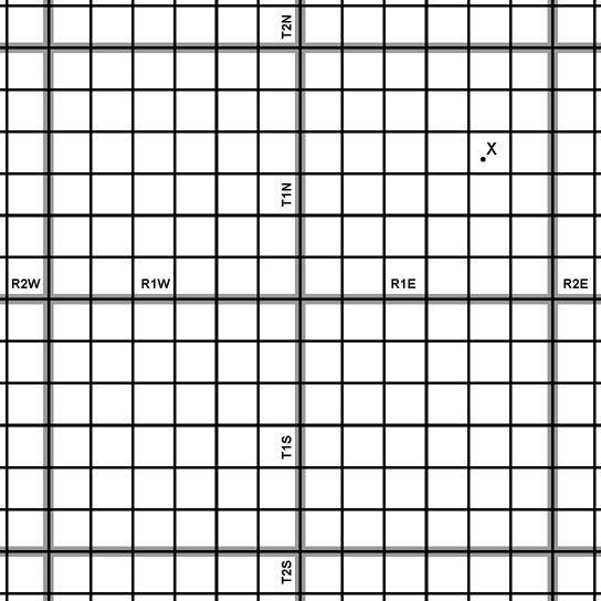 11. In your new CSI investigative reporting job, you received a call from a desperate Nebraska farmer that says an unusual flying object came out a cloud and crash landed in one of his corn fields. He sends you a fax with part of a topographic map with a dot (next to an "X") showing where "the thing" has landed. You now have to report to the proper authorities how to find this location. It is located at: a. NE, SW, Section 17, T1N, R2E. b. SW, NE, Section 17, TIN, R1E. c. NE, SW, Section 14, T1N, R1E. d. SW, NE, Section 14, T1S, R1E. e. none of the above. 12. Map scale refers to the relationship (or ratio) between distance on a map and the corresponding distance on the ground (relative to both miles and kilometers. On a standard USGS 7.5 minute quadrangle map, the scale is: a) 1:24,000. b) 1 inch = 2000 feet. c) 1:100,000. d) answers a and b. 13. Geographic Information Systems (GIS) are capable of integrating thematic information into 2 and 3 dimensional perspectives in map view. A commonly used form of raw elevation data representing the ground surface topography or terrain used to make a shaded relief map is called a: a. a DEM. b. a DOQ. c. sun shading. d. a KML. 14. A region that has distinct landforms and subregions with shared physical characteristics, such as topography (relief), geologic history, ecology, and climate. a. topographic map. b. geomorphology. c. physiographic province. d. shaded-relief map. 15. What do open colored portions of a geologic map represent? a. areas where the becrock in a region consist rock formations of similar geologic age and composition. b. the area where cities are located. c. the location of faults. d. All of the above. 16. What do lines on a geologic map represent? a. the boundaries between rock units. b. they may represent the trace of faults. c. they may represent the axis of structural features (such a folds). d. all of the above. Clues where to find answers. |
12/10/2017